Category:St Clare's presbytery, Liverpool
Jump to navigation
Jump to search
| Object location | | View all coordinates using: OpenStreetMap |
|---|
This is a category about listed building number 1068394. |
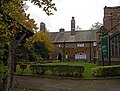
presbytery in Sefton Park, Liverpool, Merseyside, England, UK  | |||||
| Upload media | |||||
| Instance of | |||||
|---|---|---|---|---|---|
| Location | Sefton Park, Liverpool, Merseyside, North West England, England | ||||
| Heritage designation |
| ||||
 | |||||
Media in category "St Clare's presbytery, Liverpool"
The following 4 files are in this category, out of 4 total.
-
 St Clare's presbytery 1.jpg 5,152 × 3,864; 7.98 MB
-
 St Clare's presbytery 2.jpg 4,746 × 3,606; 8.56 MB
-
 St Clare's Presbytery, 201711-1.jpg 4,622 × 3,193; 12.24 MB
-
 St Clare's Presbytery, 201711-2.jpg 4,512 × 3,234; 9.42 MB


