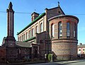
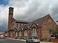
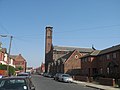
Category:St Bridget & St Thomas, Wavertree
Jump to navigation
Jump to search
| Object location | | View all coordinates using: OpenStreetMap |
|---|
church in Liverpool, Merseyside, England, UK  | |||||
| Upload media | |||||
| Instance of | |||||
|---|---|---|---|---|---|
| Named after | |||||
| Dedicated to | |||||
| Location | Liverpool, Merseyside, North West England, England | ||||
| Architectural style | |||||
| Diocese | |||||
| Heritage designation |
| ||||
| Inception |
| ||||
| Religion or worldview | |||||
| official website | |||||
 | |||||
Subcategories
This category has only the following subcategory.
Media in category "St Bridget & St Thomas, Wavertree"
The following 14 files are in this category, out of 14 total.
-
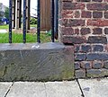 Benchmark at St Bridget's, Bagot Street.jpg 3,936 × 3,540; 6.82 MB
-
 St Bridget, Liverpoool, June 10 2010 015.jpg 2,304 × 3,072; 1,015 KB
-
 Salviati Reredos at St Bridget with St Thomas Church Liverpool.jpg 3,200 × 2,400; 953 KB
-
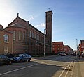
 St Bridget & St Thomas, Lawrence Road.jpg 2,025 × 1,371; 445 KB
-
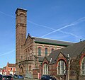
 St Bridget & St Thomas, Wavertree (rear view).JPG 4,320 × 3,240; 4.15 MB
-
 St Bridget & St Thomas, Wavertree 1.jpg 4,008 × 3,696; 6.74 MB
-
 St Bridget & St Thomas, Wavertree 10.jpg 3,674 × 3,465; 6.26 MB
-
 St Bridget & St Thomas, Wavertree 2.jpg 4,696 × 3,480; 6.67 MB
-
 St Bridget & St Thomas, Wavertree 3.jpg 4,559 × 3,497; 8.22 MB
-
 St Bridget & St Thomas, Wavertree 7.jpg 3,216 × 4,472; 6.48 MB
-
 St Bridget & St Thomas, Wavertree 8.jpg 4,624 × 3,568; 8.75 MB
-
 St Bridget's Church, Wavertree.jpg 640 × 480; 86 KB
-
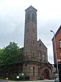
 Tower of St Bridget & St Thomas, Lawrence Road.jpg 1,536 × 2,048; 306 KB
-
 Bagot Street with St Bridget's Church - geograph.org.uk - 386541.jpg 640 × 480; 59 KB


.JPG)


Categories:
- 1870s brick churches in England
- 19th-century churches in Merseyside
- Anglican churches in Liverpool
- Brick churches in Merseyside
- Churches in England built in 1872
- Churches in the Diocese of Liverpool
- Grade II* listed churches in Liverpool
- Italianate churches in Merseyside
- Saint Brigid of Kildare churches in Merseyside
- Wavertree