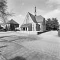
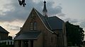
Category:St. Suitbertus (Stokkum)
Jump to navigation
Jump to search
| Object location | | View all coordinates using: OpenStreetMap |
|---|
former RK church in Stokkum, Montferland, the Netherlands .jpg) | |||||
| Upload media | |||||
| Instance of | |||||
|---|---|---|---|---|---|
| Location | Stokkum, Gelderland, Montferland, Gelderland, Netherlands | ||||
| Street address |
| ||||
| Architect | |||||
| Inception |
| ||||
| Religion or worldview | |||||
 | |||||
Nederlands: Stokkum, Pastoor van Sonsbeeckstraat 22 - St. Suitbertuskerk - anno 1915
Media in category "St. Suitbertus (Stokkum)"
The following 5 files are in this category, out of 5 total.
-
 Exterieur OVERZICHT ZUIDWESTGEVEL - Stokkum - 20339559 - RCE.jpg 1,190 × 1,200; 323 KB
-
 Exterieur OVERZICHT ZUIDWESTGEVEL - Stokkum - 20339559 - RCE (crop1).jpg 1,174 × 818; 214 KB
-
 Montferland stokkum - Pastoor van Sonsbeeckstraat 22 (monument).jpg 3,920 × 2,204; 1.52 MB
-
 Stokkum St. Suitbertus PM19-01.jpg 4,896 × 3,672; 8.08 MB
-
 Stokkum, RK kerk Sint Suitbertus GM1955-88 foto5 2015-05-14 16.56.jpg 4,111 × 3,264; 8.43 MB

.jpg)

