Category:St. Michaelskirche (Woltersdorf bei Berlin)
Jump to navigation
Jump to search
| Object location | | View all coordinates using: OpenStreetMap |
|---|
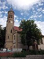
church building in Oder-Spree district, Brandenburg state, Germany  | |||||
| Upload media | |||||
| Instance of | |||||
|---|---|---|---|---|---|
| Location | Woltersdorf, Oder-Spree District, Brandenburg, Germany | ||||
| Heritage designation | |||||
 | |||||
Deutsch: Die St. Michaelskirche in Woltersdorf bei Berlin, dritter Bau, erbaut 1855–1857
Media in category "St. Michaelskirche (Woltersdorf bei Berlin)"
The following 9 files are in this category, out of 9 total.
-
 2018-08-08 DE-BB Woltersdorf, Rudolf-Breitscheid-Straße, St. Michael (49867731592).jpg 3,465 × 6,160; 3.6 MB
-
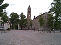 Center of Woltersdorf bei Berlin.jpg 2,048 × 1,536; 621 KB
-
 Church Woltersdorf.jpg 1,174 × 880; 469 KB
-
 Clp 20120809 St.-Michaels-Kirche Woltersdorf.jpg 1,200 × 1,600; 1.55 MB
-
 Kirche Woltersdorf.jpg 856 × 937; 265 KB
-
 St.-Michael-Kirche Woltersdorf.jpg 897 × 880; 291 KB
-
 Woltersdorf church.jpg 660 × 880; 209 KB
-
 Woltersdorf Kirche 2012-08-09 CLP 01 TBG.jpg 1,200 × 1,600; 1.29 MB
-
 Woltersdorf Kirche 2012-08-09 CLP 02.jpg 882 × 1,480; 574 KB
.jpg)


Categories:
- Churches in Woltersdorf (bei Berlin)
- Cultural heritage monuments in Woltersdorf (bei Berlin)
- Saint Michael churches in Brandenburg
- Churches in Kirchenkreis Oderland-Spree
- Lutheran churches in Brandenburg
- Gothic Revival brick churches in Brandenburg
- 1850s brick churches in Brandenburg
- Churches in Brandenburg built in 1857