Category:St. Marien (Klostermansfeld)
Jump to navigation
Jump to search
| Object location | | View all coordinates using: OpenStreetMap |
|---|
church building in Klostermansfeld, Saxony-Anhalt, Germany   | |||||
| Upload media | |||||
| Instance of | |||||
|---|---|---|---|---|---|
| Part of | |||||
| Named after | |||||
| Location | Klostermansfeld, Mansfelder Grund-Helbra, Mansfeld-Südharz, Saxony-Anhalt, Germany | ||||
| Heritage designation | |||||
 | |||||
This is the category of the Saxony-Anhalt Kulturdenkmal (cultural heritage monument) with the ID 09408047 (Wikidata)
|
Subcategories
This category has only the following subcategory.
Media in category "St. Marien (Klostermansfeld)"
The following 8 files are in this category, out of 8 total.
-
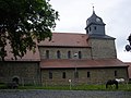
 Klosterkirche Klostermansfeld.JPG 4,000 × 3,000; 6.08 MB
-
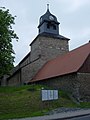
 Klostermansfeld Klosterkirche 1.jpg 2,200 × 1,650; 1.11 MB
-
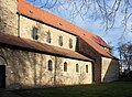
 Klostermansfeld Klosterkirche 2.jpg 1,650 × 2,200; 1.03 MB
-
 Klostermansfeld, die Kirche St. Marien (Detail).jpg 2,698 × 1,750; 3.88 MB
-
 Klostermansfeld, die Kirche St. Marien.jpg 1,755 × 2,630; 4.16 MB
-
 Klostermansfeld, the monastery church St. Mary, image 1.jpg 2,168 × 3,784; 3.51 MB
-
 Klostermansfeld, the monastery church St. Mary, image 2.jpg 3,848 × 2,831; 3.69 MB
-
 Klostermansfeld, the monastery church St. Mary, image 3.jpg 2,245 × 4,326; 2.01 MB


.jpg)


