Category:St. Joseph Kirchplatz, Grafenrheinfeld
Jump to navigation
Jump to search
| Object location | | View all coordinates using: OpenStreetMap |
|---|
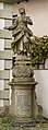
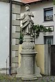
This is the category of the Bavarian Baudenkmal (cultural heritage monument) with the ID D-6-78-136-17 (Wikidata)
|
Deutsch: Standbild des heiligen Joseph, 1769. Vor Kirchplatz 4, Grafenrheinfeld, Landkreis Schweinfurt, Unterfranken, Deutschland
Media in category "St. Joseph Kirchplatz, Grafenrheinfeld"
The following 3 files are in this category, out of 3 total.
-
 Grafenrheinfeld St Joseph statue HRS-20231008-RM-164541.jpg 2,742 × 7,413; 10.25 MB
-
 Grafenrheinfeld, Kirchplatz, Hl. Josef-001.jpg 3,264 × 4,928; 9.43 MB
-
 Joseph Kirchplatz 4.JPG 2,132 × 3,180; 1.61 MB

