Category:St. Josef (Hörnum)
Jump to navigation
Jump to search
| Object location | | View all coordinates using: OpenStreetMap |
|---|
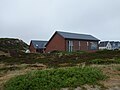
church building in Hörnum, Germany  | |||||
| Upload media | |||||
| Instance of | |||||
|---|---|---|---|---|---|
| Named after | |||||
| Location | Hörnum (Sylt), Landschaft Sylt, Nordfriesland district, Schleswig-Holstein, Germany | ||||
| Service retirement |
| ||||
| Inception |
| ||||
| Religion or worldview | |||||
 | |||||
English: Pictures of the former church "St.Josef" in Hörnum, Sylt Isle of, Nordfriesland district, Schleswig-Holstein state, Germany.
Deutsch: Ansichten der ehemaligen Kirche "St.Josef" in Hörnum, Insel Sylt , Landkreis Nordfriesland , Land Schleswig-Holstein , Deutschland.
Français : Photos de l'ancienne église "St.Josef" à Hörnum, Île de de Sylt, , arrondissement de Nordfriesland , état federé de Schleswig-Holstein , Allemagne.
Español: Vistas de la antigua iglesia "St.Josef" en Hörnum, Isla de de Sylt, distrito de Nordfriesland , estado federado de Schleswig-Holstein , Alemania.
Address: Rantumer Str. 33, 25997 Hörnum (Sylt)
Media in category "St. Josef (Hörnum)"
The following 6 files are in this category, out of 6 total.
-
 20170410 xl P1100748-Hoernum-Arche-Wattenmeer.jpg 4,896 × 3,672; 5.78 MB
-
 Ehemalige St.Josefs-Kirche Hörnum 2015 SE.jpg 2,592 × 1,944; 2.07 MB
-
 Ehemalige St.Josefs-Kirche Hörnum 2018 Innen W.jpg 5,296 × 4,735; 7.53 MB
-
 Ehemalige St.Josefs-Kirche Hörnum 2018 NE.jpg 4,864 × 3,648; 4.61 MB
-
 Ehemalige St.Josefs-Kirche Hörnum 2018 SW.jpg 4,864 × 3,648; 4.68 MB
-
 Ehemalige St.Josefs-Kirche Hörnum 2024 E.jpg 3,176 × 2,382; 1.59 MB


