Category:St. John's Church, Montreux
Jump to navigation
Jump to search
| Object location | | View all coordinates using: OpenStreetMap |
|---|
church building in Montreux in the canton of Vaud, Switzerland  | |||||
| Upload media | |||||
| Instance of | |||||
|---|---|---|---|---|---|
| Part of | |||||
| Location | Territet, Montreux, Riviera-Pays-d'Enhaut District, canton Vaud, Switzerland | ||||
| Street address |
| ||||
| Heritage designation | |||||
 | |||||
Media in category "St. John's Church, Montreux"
The following 5 files are in this category, out of 5 total.
-
 Eglise anglaise Territet.tif 5,500 × 3,635; 57.25 MB
-
 Montreux-Territet St John's vue extérieure.jpg 2,048 × 1,536; 1.24 MB
-
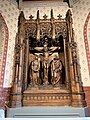 Montreux-Territet St John's, retable Crucifixion 1912.jpg 1,536 × 2,048; 1.39 MB
-
 Montreux-Territet St John's, Vitrail du porche 1886.jpg 1,536 × 2,048; 1.28 MB
-
 Église anglicane St John's, Territet.jpg 3,024 × 4,032; 2.74 MB


