Category:St. Jansstraat 47A, Laren
Jump to navigation
Jump to search
| Object location | | View all coordinates using: OpenStreetMap |
|---|
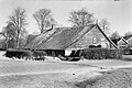
farmhouse in Laren, Netherlands  | |||||
| Upload media | |||||
| Instance of | |||||
|---|---|---|---|---|---|
| Location | Laren, North Holland, Netherlands | ||||
| Street address |
| ||||
| Located on street |
| ||||
| Heritage designation |
| ||||
 | |||||
|
This is a category about rijksmonument number 23962
|
| Address |
|
Media in category "St. Jansstraat 47A, Laren"
The following 8 files are in this category, out of 8 total.
-
 Aanzicht - Laren - 20129187 - RCE.jpg 1,200 × 809; 254 KB
-
 Aanzicht - Laren - 20129188 - RCE.jpg 1,200 × 803; 180 KB
-
-
 Gooise hoeve", voorgevel - Laren - 20129189 - RCE.jpg 1,200 × 795; 258 KB
-
 Laren stjan47A.jpg 3,648 × 2,736; 6.54 MB
-
 Voorgevel nr. OZ 5 - Laren - 20478718 - RCE.jpg 1,200 × 900; 201 KB
-
 Voorgvel nr. OZ 6 - Laren - 20478716 - RCE.jpg 1,200 × 900; 216 KB
-
 Zij- en achtergevel nr. OZ 4 - Laren - 20478717 - RCE.jpg 1,200 × 900; 228 KB


