Category:St. Gertrud (Tüddern)
Jump to navigation
Jump to search
| Object location | | View all coordinates using: OpenStreetMap |
|---|
  | |||||
| Upload media | |||||
| Instance of | |||||
|---|---|---|---|---|---|
| Location | Tüddern, Selfkant, Heinsberg, Cologne Government Region, North Rhine-Westphalia, Germany | ||||
| Heritage designation | |||||
 | |||||
This is the category for an architectural monument.
It is on the list of cultural monuments of Selfkant, no. 16.
It is on the list of cultural monuments of Selfkant, no. 16.
Media in category "St. Gertrud (Tüddern)"
The following 11 files are in this category, out of 11 total.
-
 Selfkant-Tüddern Denkmal-Nr. 16, Messweg 17 (4904).jpg 600 × 400; 54 KB
-
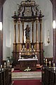 Tüddern Kirche St. Gertrud Altar.JPG 800 × 1,200; 103 KB
-
 Tüddern Kirche St. Gertrud Ansicht.JPG 1,200 × 800; 149 KB
-
 Tüddern Kirche St. Gertrud Beichtstuhl.JPG 800 × 1,200; 73 KB
-
 Tüddern Kirche St. Gertrud Chorraum.JPG 1,200 × 800; 107 KB
-
 Tüddern Kirche St. Gertrud Hochformat.jpg 600 × 900; 88 KB
-
 Tüddern Kirche St. Gertrud Innenansicht.JPG 1,200 × 800; 98 KB
-
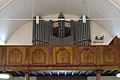 Tüddern Kirche St. Gertrud Orgel.JPG 1,200 × 800; 80 KB
-
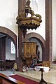 Tüddern Kirche St. Gertrud Predigtstuhl.JPG 800 × 1,200; 102 KB
-
 Tüddern Kirche St. Gertrud Seitenansicht.JPG 1,200 × 800; 98 KB
-
 Tüddern, kerk foto6 2011-03-20 09.49.JPG 4,416 × 3,312; 12.7 MB
.jpg)


