Category:St. Georg (Steinbild)
Jump to navigation
Jump to search
| Object location | | View all coordinates using: OpenStreetMap |
|---|
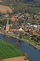
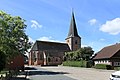
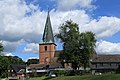
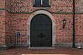
church in Kluse, Germany  | |||||
| Upload media | |||||
| Instance of | |||||
|---|---|---|---|---|---|
| Named after | |||||
| Location | Kluse, Emsland, Lower Saxony, Germany | ||||
 | |||||
Subcategories
This category has the following 2 subcategories, out of 2 total.
I
Media in category "St. Georg (Steinbild)"
The following 32 files are in this category, out of 32 total.
-
 2013-05-03 Fotoflug Leer Papenburg DSCF6983.jpg 1,673 × 2,500; 2.86 MB
-
 2013-05-03 Fotoflug Leer Papenburg DSCF6984.jpg 2,500 × 1,673; 3.07 MB
-
 2013-05-03 Fotoflug Leer Papenburg DSCF6986.jpg 2,500 × 1,673; 2.9 MB
-
 2013-05-03 Fotoflug Leer Papenburg DSCF6987.jpg 2,500 × 1,673; 2.93 MB
-
 2013-05-03 Fotoflug Leer Papenburg DSCF6988.jpg 2,500 × 1,673; 3.24 MB
-
 Kluse - DEK+Ems + Sankt-Georg-Kirche (Emsbrücke Steinbild) 01 ies.jpg 5,616 × 3,744; 18.04 MB
-
 Kluse - DEK+Ems + Sankt-Georg-Kirche (Emsbrücke Steinbild) 02 ies.jpg 3,744 × 5,616; 17.01 MB
-
 Kluse - DEK+Ems + Sankt-Georg-Kirche (Emsbrücke Steinbild) 03 ies.jpg 5,616 × 3,744; 16.76 MB
-
 Kluse - Steinbild - Emsstraße + Marktstraße 04 ies.jpg 5,616 × 3,744; 19.46 MB
-
 Kluse - Steinbild - Emsstraße + St. Georg 01 ies.jpg 5,616 × 3,744; 15.47 MB
-
 Kluse - Steinbild - Kirchstraße + St. Georg 01 ies.jpg 3,744 × 5,616; 27.14 MB
-
 Kluse - Steinbild - Kirchstraße + St. Georg 02 ies.jpg 5,616 × 3,744; 19.55 MB
-
 Kluse - Steinbild - Kirchstraße + St. Georg 03 ies.jpg 5,616 × 3,746; 19.46 MB
-
 Kluse - Steinbild - Kirchstraße + St. Georg 04 ies.jpg 5,616 × 3,744; 19.77 MB
-
 Kluse - Steinbild - Kirchstraße + St. Georg 05 ies.jpg 5,616 × 3,744; 18.96 MB
-
 Kluse - Steinbild - Kirchstraße + St. Georg 06 ies.jpg 5,616 × 3,745; 17.72 MB
-
 Kluse - Steinbild - Kirchstraße + St. Georg 07 ies.jpg 5,616 × 3,744; 17.05 MB
-
 Kluse - Steinbild - Kirchstraße - St. Georg 01 ies.jpg 3,743 × 5,616; 17.38 MB
-
 Kluse - Steinbild - Kirchstraße - St. Georg 02 ies.jpg 5,616 × 3,743; 17.89 MB
-
 Kluse - Steinbild - Kirchstraße - St. Georg 03 ies.jpg 5,616 × 3,743; 17.98 MB
-
 Kluse - Steinbild - Kirchstraße - St. Georg 04 ies.jpg 5,616 × 3,743; 19.15 MB
-
 Kluse - Steinbild - Kirchstraße - St. Georg 05 ies.jpg 5,616 × 3,744; 19.53 MB
-
 Kluse - Steinbild - Kirchstraße - St. Georg 06 ies.jpg 5,616 × 3,744; 15.75 MB
-
 Kluse - Steinbild - Kirchstraße - St. Georg 07 ies.jpg 5,616 × 3,743; 17.37 MB
-
 Kluse - Steinbild - Kirchstraße - St. Georg 08 ies.jpg 3,744 × 5,616; 15.01 MB
-
 Kluse - Steinbild - Kirchstraße - St. Georg 09 ies.jpg 5,616 × 3,745; 17.27 MB
-
 Kluse - Steinbild - Kirchstraße - St. Georg 10 ies.jpg 5,616 × 3,744; 13.89 MB
-
 Kluse - Steinbild - Kirchstraße - St. Georg 11 ies.jpg 5,616 × 3,744; 20.26 MB
-
 Kluse - Steinbild - Marktstraße + St. Georg 01 ies.jpg 5,616 × 3,744; 17 MB
-
 Luftaufnahmen Nordseekueste 2013 05 by-RaBoe 123.jpg 2,600 × 1,727; 2.9 MB
-
 Steinbild, kerk 2008-08-31 14.21.JPG 2,304 × 3,072; 1.95 MB
-
 Walchum+Kluse - Steinbilder Straße - Marinapark + DEK+Ems 04 ies.jpg 5,616 × 3,744; 19.76 MB


_01_ies.jpg)
_02_ies.jpg)
_03_ies.jpg)


