Category:St. Georg (Etzgersrieth)
Jump to navigation
Jump to search
| Object location | | View all coordinates using: OpenStreetMap |
|---|
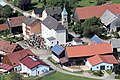
building in Etzgersrieth, Upper Palatinate, Germany  | |||||
| Upload media | |||||
| Instance of | |||||
|---|---|---|---|---|---|
| Named after | |||||
| Location | Moosbach, Neustadt an der Waldnaab, Upper Palatinate, Bavaria, Germany | ||||
| Street address |
| ||||
| Has part(s) |
| ||||
| Heritage designation | |||||
 | |||||
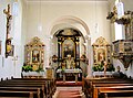
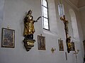
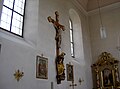
This is the category of the Bavarian Baudenkmal (cultural heritage monument) with the ID D-3-74-137-23 (Wikidata)
|
Subcategories
This category has only the following subcategory.
Media in category "St. Georg (Etzgersrieth)"
The following 26 files are in this category, out of 26 total.
-
 Etzgersrieth 2017 04.JPG 5,184 × 3,456; 9.59 MB
-
 Etzgersrieth 2017 08.JPG 3,107 × 2,072; 5.97 MB
-
 Etzgersrieth Kirche Orgel.jpg 3,995 × 2,996; 6.65 MB
-
 EtzgersriethKirche 01.jpg 2,304 × 1,704; 580 KB
-
 EtzgersriethKirche 02.jpg 2,304 × 1,704; 677 KB
-
 EtzgersriethKirche 03.jpg 2,304 × 1,704; 715 KB
-
 EtzgersriethKirche 04.jpg 2,304 × 1,704; 629 KB
-
 EtzgersriethKirche 05.jpg 2,304 × 1,704; 431 KB
-
 EtzgersriethKirche 07.jpg 2,304 × 1,704; 868 KB
-
 EtzgersriethKirche 08.jpg 2,304 × 1,704; 891 KB
-
 EtzgersriethKirche 09.jpg 2,304 × 1,704; 601 KB
-
 EtzgersriethKirche.JPG 2,304 × 1,704; 774 KB
-
 EtzgersriethKircheInnen.JPG 2,304 × 1,704; 4.77 MB
-
 EtzgersriethStGeorg 01.JPG 2,304 × 1,704; 453 KB
-
 EtzgersriethStGeorg 02.JPG 2,304 × 1,704; 563 KB
-
 EtzgersriethStGeorg 03.JPG 2,304 × 1,704; 520 KB
-
 EtzgersriethStGeorg 04.JPG 2,304 × 1,704; 574 KB
-
 EtzgersriethStGeorg 05.JPG 2,304 × 1,704; 742 KB
-
 EtzgersriethStGeorg 06.JPG 2,304 × 1,704; 746 KB
-
 EtzgersriethStGeorg 07.JPG 2,304 × 1,704; 634 KB
-
 EtzgersriethStGeorg 08.JPG 2,304 × 1,704; 426 KB
-
 EtzgersriethStGeorg 09.JPG 2,304 × 1,704; 553 KB
-
 EtzgersriethStGeorg 11.JPG 2,304 × 1,704; 848 KB
-
 EtzgersriethStGeorg 12.JPG 2,304 × 1,704; 906 KB
-
 EtzgersriethStGeorg 13.JPG 2,304 × 1,704; 798 KB
-
 Kirche Etzgersrieth.jpg 1,280 × 960; 740 KB


