Category:St. Birgitta (Weiberg)
Jump to navigation
Jump to search
| Object location | | View all coordinates using: OpenStreetMap |
|---|
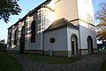
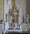
church building in Büren, Germany  | |||||
| Upload media | |||||
| Instance of | |||||
|---|---|---|---|---|---|
| Named after | |||||
| Location | Büren, Paderborn, Detmold Government Region, North Rhine-Westphalia, Germany | ||||
| Heritage designation | |||||
 | |||||
This is the category for an architectural monument.
It is on the list of cultural monuments of Büren, no. 10/5.
It is on the list of cultural monuments of Büren, no. 10/5.
Media in category "St. Birgitta (Weiberg)"
The following 10 files are in this category, out of 10 total.
-
 Church Weiberg.JPG 3,888 × 2,592; 4.46 MB
-
 Hochaltar der Sankt-Birgitta-Kirche in Weiberg.JPG 3,456 × 5,184; 7.84 MB
-
 St. Birgitta, 1, Weiberg, Büren, Landkreis Paderborn.jpg 3,456 × 2,592; 6.41 MB
-
 Weiberg - St. Birgitta - 1.jpg 4,787 × 3,377; 7.77 MB
-
 Weiberg - St. Birgitta - 2.jpg 4,864 × 3,648; 6.36 MB
-
 Weiberg - St. Birgitta - Kanzel.jpg 1,309 × 3,515; 1.56 MB
-
 Weiberg - St. Birgitta - nördlicher Seitenaltar.jpg 3,648 × 4,125; 5.67 MB
-
 Weiberg - St. Birgitta - Portal, Wappen.jpg 4,864 × 3,648; 7.92 MB
-
 Weiberg - St. Birgitta - Portal.jpg 3,151 × 4,691; 6.26 MB
-
 Weiberg - St. Birgitta - südlicher Seitenaltar.jpg 2,530 × 4,864; 4.39 MB


Categories:
- Cultural heritage monuments in Büren (Westfalen)
- Churches in Büren (Westfalen)
- Churches in Dekanat Büren-Delbrück
- Churches in North Rhine-Westphalia built in 1751
- Saint Bridget of Sweden churches in Germany
- Weiberger Straße (Büren)
- Parish churches in North Rhine-Westphalia
- Cultural heritage monuments in Kreis Paderborn (churches)
- Baroque churches in Ostwestfalen-Lippe
- Weiberg (Büren)
- Aisleless churches in Ostwestfalen-Lippe