Category:St. Barbara (Mönchengladbach)
Jump to navigation
Jump to search
| Object location | | View all coordinates using: OpenStreetMap |
|---|
church building in Mönchengladbach, Germany .jpg) | |||||
| Upload media | |||||
| Instance of | |||||
|---|---|---|---|---|---|
| Named after | |||||
| Made from material | |||||
| Location | Mönchengladbach, Düsseldorf Government Region, North Rhine-Westphalia, Germany | ||||
| Diocese | |||||
| Heritage designation | |||||
 | |||||
Media in category "St. Barbara (Mönchengladbach)"
The following 15 files are in this category, out of 15 total.
-
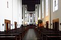 Am Wasserturm, Kirche St. Barbara Ansicht Innen.jpg 2,400 × 1,600; 295 KB
-
 Am Wasserturm, Kirche St. Barbara Beichtstuhl.jpg 2,400 × 1,600; 239 KB
-
 Am Wasserturm, Kirche St. Barbara Buntfenster.jpg 2,400 × 1,600; 331 KB
-
 Am Wasserturm, Kirche St. Barbara Buntwand.jpg 1,600 × 2,400; 336 KB
-
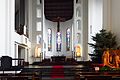 Am Wasserturm, Kirche St. Barbara Chor.jpg 2,400 × 1,600; 347 KB
-
 Am Wasserturm, Kirche St. Barbara Chorstuhl.jpg 2,400 × 1,600; 353 KB
-
 Am Wasserturm, Kirche St. Barbara Kreuzschrift.jpg 1,600 × 2,400; 523 KB
-
 Am Wasserturm, Kirche St. Barbara Krippe.jpg 2,400 × 1,600; 415 KB
-
 Am Wasserturm, Kirche St. Barbara Messbuch.jpg 1,600 × 2,400; 224 KB
-
 Am Wasserturm, Kirche St. Barbara Tabernakel.jpg 1,600 × 2,400; 379 KB
-
 Am Wasserturm, Kirche St. Barbara Taufstein.jpg 2,400 × 1,600; 310 KB
-
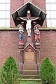 Am Wasserturm, St. Barbara Kreuzgruppe.jpg 1,600 × 2,400; 560 KB
-
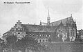 Franziskanerkloster Mönchen-Gladbach um 1900.jpg 1,078 × 675; 249 KB
-
 Mönchengladbach-MG Mitte Denkmal-Nr. B 130, Bettrather Straße 79 (5563).jpg 2,400 × 1,600; 318 KB
-
 Mönchengladbach-MG Mitte Denkmal-Nr. B 130, Bettrather Straße 79 (5564).jpg 2,400 × 1,600; 549 KB


.jpg)
Categories:
- Roman Catholic churches in Mönchengladbach
- Cultural heritage monuments in Mönchengladbach
- Saint Barbara churches in North Rhine-Westphalia
- Franciscan friaries in North Rhine-Westphalia
- Monastery churches in North Rhine-Westphalia
- 1890s churches in Regierungsbezirk Düsseldorf
- Gothic Revival churches in Regierungsbezirk Düsseldorf
- 1940s churches in Regierungsbezirk Düsseldorf
- Heimatschutz churches in Regierungsbezirk Düsseldorf