Category:St. Annen (Thum)
Jump to navigation
Jump to search
| Object location | | View all coordinates using: OpenStreetMap |
|---|
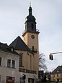
church building in Thum, Germany  | |||||
| Upload media | |||||
| Instance of | |||||
|---|---|---|---|---|---|
| Location | Thum, Erzgebirgskreis, Saxony, Germany | ||||
| Street address |
| ||||
| Heritage designation | |||||
| Inception |
| ||||
 | |||||
| (Wikidata) |
=
Subcategories
This category has the following 4 subcategories, out of 4 total.
F
- Friedhof Thum (2 F)
P
- Pfarrhaus St. Annen (Thum) (2 F)
Media in category "St. Annen (Thum)"
The following 10 files are in this category, out of 10 total.
-
 24991-Thum-1929-St. Annenkirche-Brück & Sohn Kunstverlag.jpg 1,536 × 1,000; 691 KB
-
 Ev.-luth. Kirche Thum (1).jpg 4,000 × 3,000; 2.96 MB
-
 Ev.-luth. Kirche Thum (2).jpg 3,000 × 4,000; 2.16 MB
-
 Ev.-luth. Kirche Thum (3).jpg 3,000 × 4,000; 1.64 MB
-
 Ev.-luth. Kirche Thum (4).jpg 1,978 × 2,637; 723 KB
-
 Ev.-luth. Kirche Thum (5).jpg 4,000 × 3,000; 2.69 MB
-
 Ev.-luth. Kirche Thum (6).jpg 4,000 × 3,000; 3.27 MB
-
 Kirche Thum.jpg 2,420 × 3,220; 616 KB
-
 Obelisk (Thum).jpg 3,000 × 4,000; 2.76 MB
-
 Thum - Stadtkirche St. Annen, Gedenktafel Tobias Clausnitzer.jpg 1,472 × 1,000; 1.29 MB

.jpg)
.jpg)
.jpg)
.jpg)
.jpg)
.jpg)
.jpg)
