Category:Spring in Utah
Jump to navigation
Jump to search
States of the United States: Alabama · Alaska · Arizona · California · Colorado · Connecticut · Delaware · Florida · Georgia · Idaho · Illinois · Indiana · Iowa · Kentucky · Louisiana · Maine · Maryland · Massachusetts · Michigan · Mississippi · Missouri · Montana · Nebraska · Nevada · New Jersey · New York · North Carolina · Ohio · Oregon · Pennsylvania · Rhode Island · Tennessee · Texas · Utah · Vermont · Virginia · Washington · West Virginia – Washington, D.C.
Subcategories
This category has the following 3 subcategories, out of 3 total.
A
M
Media in category "Spring in Utah"
The following 200 files are in this category, out of 720 total.
(previous page) (next page)-
 1002 S Main St, Springville, Utah, May 16.jpg 2,592 × 1,944; 2.39 MB
-
1993-06-08-Jeep-Safari-bei-Moab-(Utah).ogv 7 min 2 s, 640 × 352; 55.06 MB
-
 2002 Winter Olympics sign at Soldier Hollow, Apr 16.jpg 1,944 × 2,592; 1.6 MB
-
 2015.05.30 16.00.01 IMG 2570 - Flickr - andrey zharkikh.jpg 4,752 × 3,168; 2.66 MB
-
 2015.05.30 16.00.10 IMG 2571 - Flickr - andrey zharkikh.jpg 4,752 × 3,168; 2.49 MB
-
 2015.05.30 16.02.10 IMG 2573 - Flickr - andrey zharkikh.jpg 4,752 × 3,168; 2.67 MB
-
 2015.05.30 16.02.23 IMG 2574 - Flickr - andrey zharkikh.jpg 4,752 × 3,168; 2.4 MB
-
 2017.04.09 08.12.35 DSC06995 - Flickr - andrey zharkikh.jpg 4,896 × 3,672; 2.12 MB
-
 A bus stand at 2700 W Sugar Factory Rd, Apr 16.jpg 2,592 × 1,944; 2.36 MB
-
 A Gorgeous Drive, Utah Hwy 9, Zion NP 2014 (26741235862).jpg 2,450 × 1,999; 4.06 MB
-
 Across Cache Valley at Bear River Range in Utah.jpg 1,280 × 960; 302 KB
-
-
 Airport Tower and Island in the Sky (7257519158).jpg 1,600 × 1,067; 493 KB
-
 AlbionBasin Wasatch Penstemon Nuttall's linanthus Teresa Prendusi.jpg 974 × 730; 113 KB
-
 Alcove Fly Over, Zion NP 4-14 (17568606092).jpg 320 × 293; 51 KB
-
 Along Hwy 95 in SE Utah - shortcut along Hwy 261 - (17914025559).jpg 5,164 × 3,443; 20.26 MB
-
 Along the Virgin River, Zion, UT 5-14 (16333129958).jpg 2,450 × 1,950; 1.94 MB
-
 Alpine School District office building, American Fork, Utah, Jun 16.jpg 2,592 × 1,944; 2.27 MB
-
 American Fork Police Department & 4th District Court, American Fork, Utah, Jun 16.jpg 2,592 × 1,944; 2.38 MB
-
 American Fork Station bicycle lockers.JPG 2,816 × 2,112; 2.51 MB
-
 American Fork Station passenger platform west end.JPG 2,816 × 2,112; 2.52 MB
-
 Arby's restaurant in south Provo, Utah, Apr 16.jpg 2,592 × 1,944; 2.35 MB
-
 At the Top, Canyon Overlook Trail, Zion NP 2014 (29444524881).jpg 2,235 × 1,423; 1.43 MB
-
 Bamberger Rd tunnel under I-15 in Payson, Utah, Jun 16.jpg 2,592 × 1,944; 2.44 MB
-
 Behind hole in the rock - panoramio.jpg 1,600 × 1,200; 1.37 MB
-
 Benjamin Cemetery entrance, Benjamin, Utah, Jun 16.jpg 2,592 × 1,944; 2.31 MB
-
 Bicycle lockers at Murray Central Station.JPG 2,816 × 2,112; 2.36 MB
-
 Bicycle lockers Sandy Civic Center.JPG 2,816 × 2,112; 2.54 MB
-
 Biking near Moab, 2005.jpg 1,153 × 865; 1.18 MB
-
 Blake Richard Verdoorn 2015-05-10 (Unsplash).jpg 6,000 × 4,000; 13.33 MB
-
 BNSF approching Orem FrontRunner station.JPG 2,816 × 2,112; 2.55 MB
-
 Box Elder HS Gym Brigham City Utah.jpeg 3,296 × 2,472; 985 KB
-
 Bryce Canon Sunrise very early morning MC.jpg 4,000 × 1,471; 1.72 MB
-
 Bryce Canyon (lever de soleil).jpg 2,816 × 1,584; 2.66 MB
-
 Bryce Canyon Airport.jpeg 3,008 × 2,000; 2.67 MB
-
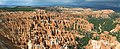 Bryce Canyon Amphitheater Hoodoos Panorama.jpg 3,827 × 1,570; 5.12 MB
-
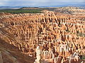 Bryce Canyon Hoodoos Amphitheater 2.jpg 2,272 × 1,704; 2.35 MB
-
 Bryce Canyon Hoodoos Amphitheater.jpg 2,272 × 1,704; 2.13 MB
-
 Bryce Canyon Hoodoos at eye level.jpg 2,272 × 1,704; 833 KB
-
 Bryce Canyon Hoodoos.jpg 2,272 × 1,704; 2.2 MB
-
 Bryce Canyon National Park, Utah (3446226863).jpg 1,024 × 683; 229 KB
-
 Bryce Canyon National Park, Utah (3446227239).jpg 1,024 × 682; 237 KB
-
 Bryce Canyon National Park, Utah (3446231199).jpg 1,024 × 683; 261 KB
-
 Bryce Canyon National Park, Utah (3446232349).jpg 1,024 × 683; 175 KB
-
 Bryce Canyon National Park, Utah (3446233213).jpg 1,024 × 683; 297 KB
-
 Bryce Canyon National Park, Utah (3447039218).jpg 1,024 × 683; 233 KB
-
 Bryce Canyon National Park, Utah (3447039690).jpg 1,024 × 683; 310 KB
-
 Bryce Canyon National Park, Utah (3447040138).jpg 1,024 × 683; 262 KB
-
 Bryce Canyon National Park, Utah (3447040480).jpg 1,024 × 683; 185 KB
-
 Bryce Canyon National Park, Utah (3447040872).jpg 1,024 × 683; 276 KB
-
 Bryce Canyon National Park, Utah (3447042238).jpg 1,024 × 683; 343 KB
-
 Bryce Canyon National Park, Utah (3447042700).jpg 1,024 × 683; 290 KB
-
 Bryce Canyon National Park, Utah (3447043212).jpg 1,024 × 683; 337 KB
-
 Bryce Canyon National Park, Utah (3447043728).jpg 1,024 × 683; 328 KB
-
 Bryce Canyon National Park, Utah (3447044222).jpg 1,024 × 683; 287 KB
-
 Bryce Canyon National Park, Utah (3447044908).jpg 1,024 × 683; 257 KB
-
 Bryce Canyon National Park, Utah (3447046594).jpg 1,024 × 683; 281 KB
-
 Bryce Canyon National Park, Utah (3447047226).jpg 683 × 1,024; 194 KB
-
 Bryce Canyon Parc national (1).jpg 4,312 × 3,228; 6.68 MB
-
 Bryce Canyon Parc national (11).jpg 2,912 × 2,876; 5.69 MB
-
 Bryce Canyon Parc national (13).jpg 3,187 × 3,187; 5.89 MB
-
 Bryce Canyon Parc national (16).jpg 3,240 × 4,320; 4.94 MB
-
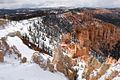
 Bryce Canyon, Rim Trail 01.jpg 4,288 × 2,848; 6.23 MB
-
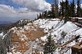
 Bryce Canyon, Rim Trail 02.jpg 4,288 × 2,848; 4.58 MB
-
 Bryce Canyon, Rim Trail 03.jpg 4,288 × 2,848; 4.86 MB
-
 Bryce Canyon, Rim Trail 04.jpg 4,288 × 2,848; 4.97 MB
-
 Bryce Canyon, Rim Trail 06.jpg 4,318 × 2,869; 6.02 MB
-
 Bus stands at the American Fork Station.JPG 2,816 × 2,112; 2.28 MB
-
 Bus stands Sandy Civi Center.JPG 2,816 × 2,112; 2.28 MB
-
 Cabin in Zion NP 5-14 (18654647703).jpg 2,400 × 2,119; 2.81 MB
-
 Campus Summer Shots (2312860225) (2).jpg 1,530 × 2,048; 808 KB
-
 Canyon Overlook, Zion 4-14 (15895120639).jpg 2,450 × 1,589; 2.33 MB
-
 Canyon Overlook, Zion NP, 2014 (31777741381).jpg 2,485 × 1,779; 1.72 MB
-
 Canyon Sunrise, Zion 5-14 (15903717457).jpg 2,250 × 1,507; 1.29 MB
-
 Canyon Walls, Riverside Walk 5-1-14a (14080902870).jpg 1,808 × 2,070; 1.48 MB
-
 Canyons Resort Transit Hub in Summit County, Utah, Apr 16.jpg 2,592 × 1,944; 2.37 MB
-
 Capital Hall, Salt Lake City - panoramio.jpg 3,072 × 2,304; 634 KB
-
 Capital of Utah, Salt Lake City - panoramio (1).jpg 3,072 × 2,304; 682 KB
-
 Capital of Utah, Salt Lake City - panoramio (2).jpg 3,072 × 2,304; 430 KB
-
 Capital of Utah, Salt Lake City - panoramio.jpg 3,072 × 2,304; 432 KB
-
 Capitol of Utah, Sale Lake City - panoramio.jpg 3,072 × 2,304; 467 KB
-
 Capitol Reef National Park (7333998344).jpg 2,121 × 1,414; 3.38 MB
-
 Cassidy Arch (7440933594).jpg 1,101 × 900; 1.24 MB
-
 Causey Dam (14112747322).jpg 648 × 476; 93 KB
-
 Central Bank in Payson, Utah, May 16.jpg 2,592 × 1,944; 2.37 MB
-
 Choose 2 Give flags (40885264144).jpg 3,859 × 3,697; 3.69 MB
-
 Church Rock (Utah) on U.S. Route 191 (3455928800).jpg 2,784 × 1,856; 1 MB
-
 Church Rock - Utah.jpg 1,600 × 1,200; 668 KB
-
 Church Rock Utah 1.jpg 2,272 × 1,704; 638 KB
-
 Confederate Cemetery near Soldier Summit, Utah.JPG 3,296 × 2,472; 1.1 MB
-
 Crescent View Park and Ride.JPG 2,816 × 2,112; 2.61 MB
-
 Crescent View Station NE across Park and Ride.JPG 2,816 × 2,112; 2.59 MB
-
 Dark Canyon Wilderness.jpg 1,037 × 778; 142 KB
-
 Dead end on S State Rd, Genola, Utah, May 16.jpg 2,592 × 1,944; 2.39 MB
-
 Deer along Nebo Scenic Loop, May 16.jpg 2,592 × 1,944; 2.18 MB
-
 Deer on Emerald Pools Trail, Zion 5-14 (15767251914).jpg 2,450 × 1,867; 1.52 MB
-
 Desert scenes driving W through Utah (15438162044).jpg 5,091 × 3,394; 19.78 MB
-
 Down Along the Virgin, Zion NP 5-14 (16128722191).jpg 2,450 × 1,965; 2.7 MB
-
 Down Along the Virgin, Zion NP 5-14a (15547246813).jpg 1,875 × 2,450; 2.24 MB
-
 Down Hobble Creek from Hobble Creek Canyon Parkway, Utah County, Utah, May 16.jpg 2,592 × 1,944; 1.97 MB
-
 Down Peteetneet Creek from Grotto Falls Trail, May 16.jpg 2,592 × 1,944; 2.13 MB
-
 Draper City Police vehicle, May 16.jpg 2,592 × 1,944; 2.32 MB
-
 East across Heber Valley from Soldier Hollow, Apr 16.jpg 2,592 × 1,944; 2.38 MB
-
 East across Midway, Utah from SR-222. Apr 16.jpg 2,592 × 1,944; 2.35 MB
-
 East across Salem Lake, Salem, Utah, May 16.jpg 2,592 × 1,944; 2.11 MB
-
 East along Hobble Creek Canyon Parkway, Utah County, Utah, May 16.jpg 2,592 × 1,944; 2.29 MB
-
 East along SR-141 in West Mountain, Utah, Jun 16.jpg 2,592 × 1,944; 2.34 MB
-
 East along SR-201 from I-80 interchange, Mar 16.jpg 2,592 × 1,944; 2.41 MB
-
 East along SR-222 in Midway, Utah, Apr 16.jpg 2,592 × 1,944; 2.43 MB
-
 East along tracks from Charleston station, Apr 16.jpg 2,592 × 1,944; 2.43 MB
-
 East at bell tower in roundabout in Midway, Utah, Apr 16.jpg 2,592 × 1,944; 2.4 MB
-
 East at Canyon Road split in Hobble Creek Canyon, Utah County, Utah, May 16.jpg 2,592 × 1,944; 2.37 MB
-
 East at Dividend Road (about mm 0.5) in Utah County, Utah, May 16.jpg 2,592 × 1,944; 2.41 MB
-
 East at end of pavement on Snake Creek Rd, Apr 16.jpg 2,592 × 1,944; 2.36 MB
-
 East at Hobble Creek Canyon Parkway trailhead, Springville, Utah, May 16.jpg 2,592 × 1,944; 2.33 MB
-
 East at I-15 & SR-92 interchange, Apr 16.jpg 2,592 × 1,944; 2.39 MB
-
 East at junction of I-15, US-6, & SR-198, Santaquin, Utah, May 16.jpg 2,592 × 1,944; 2.36 MB
-
 East at Main Street & 1600 South in Mapleton, Utah, Apr 16.jpg 2,592 × 1,944; 2.4 MB
-
 East at Main Street & Maple Street in Mapleton, Utah, Apr 16.jpg 2,592 × 1,944; 2.4 MB
-
 East at N University Pkwy, N 550 W, & W 2230 N in Provo, Mar 15.jpg 2,816 × 2,112; 2.4 MB
-
 East at Palmyra Dr & W 4400 S intersection Palmyra, Utah, May 16.jpg 2,592 × 1,944; 2.36 MB
-
 East at Salem Hills High School LDS seminary building, May 16.jpg 2,592 × 1,944; 2.31 MB
-
 East at Soldier Hollow station shelter, Apr 16.jpg 2,592 × 1,944; 2.38 MB
-
 East at SR-113 & SR-222 junction, Apr 16.jpg 2,592 × 1,944; 2.46 MB
-
 East at SR-113 & US-40 US-189 junction in Heber City, Utah, Apr 16.jpg 2,592 × 1,944; 2.39 MB
-
 East at SR-147 overpass over I-15, Apr 16.jpg 2,592 × 1,944; 2.42 MB
-
 East at SR-74 & SR-92 junction, Highland, Utah, Jun 16.jpg 2,592 × 1,944; 2.38 MB
-
 East at SR-74 & US-89 junction, American Fork, Utah, Jun 16.jpg 2,592 × 1,944; 2.33 MB
-
 East at SR-92 & N Canyon Rd intersection in Utah County, Utah, Jun 16.jpg 2,592 × 1,944; 2.36 MB
-
 East at SR-92 & SR-129 in Highland, Utah, Jun 16.jpg 2,592 × 1,944; 2.35 MB
-
 East at the SR-32 & SR-35 junction in Francis, Utah, Apr 16.jpg 2,592 × 1,944; 2.31 MB
-
 East at Timpview High School front, Provo, Utah, Jun 16.jpg 2,592 × 1,944; 2.36 MB
-
 East at US-189 & SR-265 junction Provo, Utah, Apr 16.jpg 2,592 × 1,944; 2.37 MB
-
 East at US-189 & SR-52 junction, Apr 16.jpg 2,592 × 1,944; 2.39 MB
-
 East at US-6 & Dividend Rd intersection from Dividend Rd, May 16.jpg 2,592 × 1,944; 2.36 MB
-
 East at US-6 & Dividend Rd intersection from US-6, May 16.jpg 2,592 × 1,944; 2.36 MB
-
 East at US-6 & SR-68 junction, Elberta, Utah, May 16.jpg 2,592 × 1,944; 2.44 MB
-
 East at US-6 in Tucker, Utah, May 17.jpg 2,592 × 1,944; 2.09 MB
-
 East at US-6, Elberta Slant Rd, & Dividend Fork Rd intersection, May 16.jpg 2,592 × 1,944; 2.32 MB
-
 East at US-89 & SR-147 (W 1600 South) in Mapleton, Utah, Apr 16.jpg 2,592 × 1,944; 2.39 MB
-
 East at west end of SR-92 in Lehi, Utah, Apr 16.jpg 2,592 × 1,944; 2.36 MB
-
-
 East from Dividend Road (about mm 1.2) in Utah County, Utah, May 16.jpg 2,592 × 1,944; 2.34 MB
-
 East from South Jordan Parkway station, Apr 16.jpg 2,592 × 1,944; 2.39 MB
-
 East on Dividend Road (about mm 0.4) in Utah County, Utah, May 16.jpg 2,592 × 1,944; 2.38 MB
-
 East on Dividend Road (about mm 1.8) in Utah County, Utah, May 16.jpg 2,592 × 1,944; 2.29 MB
-
 East on Dividend Road from US-6, May 16.jpg 2,592 × 1,944; 2.43 MB
-
 East on Main Street, Santaquin, Utah, May 16.jpg 2,592 × 1,944; 2.36 MB
-
 East on SR-147 under US-6,.jpg 2,592 × 1,944; 2.38 MB
-
 East on SR-164 in Utah County, Utah, Jun 16.jpg 2,592 × 1,944; 2.32 MB
-
 East on SR-319 at Jordanelle State Park-Hailstone sign, Apr 16.jpg 2,592 × 1,944; 2.32 MB
-
 East on US-6 across Goshen Valley from Big Canyon, May 16.jpg 2,592 × 1,944; 2.37 MB
-
 East on US-6 at Goshen, Utah, May 16.jpg 2,592 × 1,944; 2.36 MB
-
 East on US-6 from Elberta, Utah, May 16.jpg 2,592 × 1,944; 2.42 MB
-
 East on W 400 South at I-15 interchange, Springville, Utah, May 16.jpg 2,592 × 1,944; 2.38 MB
-
 East through the Provo River Legacy Bridge, Apr 16.jpg 2,592 × 1,944; 2.29 MB
-
 East toward junction of SR-115 and SR-147, Apr 16.jpg 2,592 × 1,944; 2.33 MB
-
 East Zion National Park, UT 5-14 (16009958628).jpg 2,450 × 1,568; 1.89 MB
-
 East-northeast on US-6 from east of Goshen, Utah, May 16.jpg 2,592 × 1,944; 2.32 MB
-
 East-southeast along Blue Line TRAX beyond Pioneer Rd, Apr 15.jpg 2,816 × 2,112; 2.78 MB
-
 East-southeast at US-6 & US-89 junction in Spanish Fork, Utah, May 16.jpg 2,592 × 1,944; 2.41 MB
-
 ElbertaUTAbandonedSinclair.jpg 4,000 × 2,399; 3.74 MB
-
 Eldredge House West Bountiful Utah.jpeg 2,560 × 1,920; 1.11 MB
-
 Emerald Pools Bridge, Zion 4-14 (15893927650).jpg 2,450 × 1,804; 2.64 MB
-
 Emerald Pools Canyon, Zion 4-14 (16002445684).jpg 2,450 × 2,305; 3.21 MB
-
 End of northbound BNSF train in Springville, Utah, May 16.jpg 2,592 × 1,944; 2.33 MB
-
 Ensign Peak, 5-24-2008.jpg 768 × 1,024; 431 KB
-
 Entrance gate to Wildwood, Utah, June 16.jpg 2,592 × 1,944; 2.06 MB
-
 Ether Peak from Hobble Creek Canyon Parkway, Utah County, Utah, May 16.jpg 2,592 × 1,944; 2.47 MB
-
 Eureka Fire Station, Eureka, Utah, May 16.jpg 2,592 × 1,944; 2.32 MB
-
 Farmington Station.JPG 3,296 × 2,472; 1.11 MB
-
 Fenced In, Grafton Ghost Town, UT 4-14 (28646771351).jpg 2,100 × 2,179; 2.1 MB
-
 Field south of Draper Town Center station, Apr 15.jpg 2,816 × 2,112; 2.86 MB
-
 Fire hydrant and dandelions off State Street in Sandy, Apr 16.jpg 1,944 × 2,592; 1.49 MB
-
 Fire hydrant at 2700 W Sugar Factory Rd station, Apr 16.jpg 2,592 × 1,944; 2.36 MB
-
 First Light on Fallen Tree, Zion 5-14a (16314125154).jpg 2,450 × 2,293; 2.34 MB
-
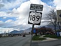 First NB US-189 Shield - panoramio.jpg 1,600 × 1,200; 520 KB
-
 First Sun along Virgin River, Zion NP 4-14 (24838258960).jpg 2,800 × 2,302; 2.35 MB
-
 First Sun in Zion Canyon 5-14 (16791857953).jpg 1,920 × 1,816; 740 KB
-
 First Sun on Patriarchs, Zion 4-14 (16055419676).jpg 2,450 × 1,759; 3.22 MB
-
 First Sun on the Virgin River, Zion 5-14 (17226198525).jpg 2,450 × 2,017; 2.54 MB
-
 First Sun on Watchman, Zion NP 5-14 (16130629945).jpg 2,450 × 1,664; 2.13 MB
-
 First Sun, Zion Canyon 2014 (16603097792).jpg 2,450 × 1,500; 2.35 MB
-
 Flowering Pear Utah.jpg 1,000 × 1,000; 829 KB
-
 Follow the Sun, Zion N.P. 4-14 (17027965907).jpg 2,150 × 1,831; 1.53 MB
-
 Foothill Treatment Center, Spanish Fork, Utah, May 16.jpg 2,592 × 1,944; 2.38 MB
-
 Former gas station along US-6 & SR-68 in Elberta, May 16.jpg 2,592 × 1,944; 2.38 MB
-
 Four Trees, Bryce Canyon National Park, Utah (3446229999).jpg 1,024 × 683; 171 KB
-
 FrontRunner at Roy Station 2.JPG 3,296 × 2,472; 944 KB
-
 FrontRunner train at Provo Station, March 2015.JPG 2,816 × 2,112; 2.58 MB
-
 Garden of Eden ArchesNP MC.jpg 6,000 × 2,006; 3.92 MB
-
 Glade's Drive Inn, Spanish Fork, Utah, Apr 16.jpg 2,592 × 1,944; 2.42 MB
-
 Gooseneck and Dead Horse Point from the Walking Rocks (7257505318).jpg 1,600 × 628; 371 KB
-
 Grand View Ranch, Springdale, UT 4-14 (16624617305).jpg 2,450 × 948; 1.37 MB
-
 Green River and Ekker Butte (7257548156).jpg 1,067 × 1,600; 502 KB
-
 Grotto Falls in Payson Canyon, May 16.jpg 2,592 × 1,944; 2.34 MB
-
 Grotto Trail, Zion NP 4-30-14m (14411242501).jpg 1,623 × 2,160; 2.24 MB
-
 Half Way Down, Zion NP, Sunrise 5-1-14z (14374520873).jpg 1,700 × 1,960; 1.81 MB
-
 Halls Crossing - Bullfrog Ferry, Lake Powell (3684657843).jpg 1,000 × 667; 162 KB
-
 Harmons in Orem, Utah, Apr 16.jpg 2,592 × 1,944; 2.35 MB


.jpg)


.jpg)

.jpg)
.jpg)
.jpg)


.jpg)


.jpg)


.jpg)


.jpg)
.jpg)
.jpg)
.jpg)
.jpg)
.jpg)
.jpg)
.jpg)
.jpg)
.jpg)
.jpg)
.jpg)
.jpg)
.jpg)
.jpg)
.jpg)
.jpg)
.jpg)
.jpg)
.jpg)
.jpg)
.jpg)


.jpg)
_(2).jpg)
.jpg)
.jpg)
.jpg)
.jpg)

.jpg)
.jpg)


.jpg)
.jpg)
.jpg)

.jpg)
_on_U.S._Route_191_(3455928800).jpg)


.jpg)
.jpg)
.jpg)
.jpg)


_in_Utah_County,_Utah,_May_16.jpg)


_in_Mapleton,_Utah,_Apr_16.jpg)


_in_Utah_County,_Utah,_May_16.jpg)

_in_Utah_County,_Utah,_May_16.jpg)
_in_Utah_County,_Utah,_May_16.jpg)


.jpg)


.jpg)
.jpg)


.jpg)


.jpg)

.jpg)
.jpg)
.jpg)
.jpg)
.jpg)
.jpg)

.jpg)


.jpg)


.jpg)

.jpg)
.jpg)
.jpg)

.jpg)
.jpg)