Category:Split Point Lighthouse
Jump to navigation
Jump to search
| Object location | | View all coordinates using: OpenStreetMap |
|---|
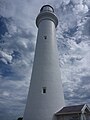
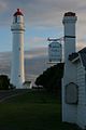
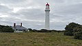
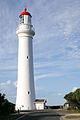
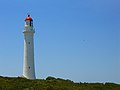
English: Split Point Lighthouse, Eagles Nest Point or "The White Queen". Located on the point at Airey's Inlet, about 120 km (75 mi) southwest of Melbourne, Australia.
lighthouse in Victoria, Australia  | |||||
| Upload media | |||||
| Instance of | |||||
|---|---|---|---|---|---|
| Location | Victoria, AUS | ||||
| Operator | |||||
| Heritage designation |
| ||||
| Service entry |
| ||||
| Inception |
| ||||
| Significant event |
| ||||
| Source of energy | |||||
| Height |
| ||||
 | |||||
Media in category "Split Point Lighthouse"
The following 58 files are in this category, out of 58 total.
-
 -i---i- (5093000218).jpg 2,592 × 3,888; 2.81 MB
-
 Aireys Inlet - Fairhaven VIC 3231, Australia - panoramio (6).jpg 11,994 × 3,088; 10.72 MB
-
 Aireys Inlet - Fairhaven VIC 3231, Australia - panoramio.jpg 3,264 × 2,448; 1.79 MB
-
 AireysInletSplitPointLighthouse.JPG 3,872 × 2,592; 2.17 MB
-
 Australia Split Point Lighthouse (9571441433).jpg 3,168 × 4,752; 2.98 MB
-
 Australia Split Point Lighthouse (9571443105).jpg 4,752 × 3,168; 1.74 MB
-
 Australia Split Point Lighthouse (9574238874).jpg 4,752 × 3,168; 1.8 MB
-
 Australia Split Point Lighthouse (9574239436).jpg 4,752 × 2,034; 1.43 MB
-
 DSC 0022 (1671175179).jpg 2,048 × 1,370; 182 KB
-
 DSC 0023 (1672030504).jpg 1,370 × 2,048; 226 KB
-
 DSC 0024 (1671180005).jpg 1,370 × 2,048; 225 KB
-
 DSC 0027 (1672037496).jpg 1,370 × 2,048; 189 KB
-
 DSC 0028 (1671186397).jpg 1,370 × 2,048; 352 KB
-
 DSC 0029 (1672040124).jpg 1,370 × 2,048; 208 KB
-
 DSC 0032 (1672043766).jpg 1,370 × 2,048; 176 KB
-
 DSC 0043 (1672063428).jpg 1,370 × 2,048; 199 KB
-
 DSC 0045 (1671214967).jpg 1,370 × 2,048; 230 KB
-
 DSC 0048 (1672070538).jpg 2,048 × 1,370; 297 KB
-
 DSC 0049 (1672072992).jpg 2,048 × 1,370; 187 KB
-
 DSCN0693 (1672344153).jpg 1,536 × 2,048; 180 KB
-
 Great Ocean Road 0480.jpg 2,592 × 1,936; 1.26 MB
-
 Great Ocean Road 0482.jpg 1,936 × 2,592; 721 KB
-
 Great Ocean Road Trip Vol 01 (51749352).jpeg 800 × 533; 54 KB
-
 Lighthouse (4277790472).jpg 3,000 × 4,000; 3.61 MB
-
 Lighthouse (4277792702).jpg 3,000 × 4,000; 3.7 MB
-
 Lighthouse (5920610160).jpg 1,424 × 2,144; 2.23 MB
-
 Lighthouse Ayres Inlet.jpg 683 × 1,024; 77 KB
-
 Originally called Eagles Nest Point (24344693875).jpg 3,290 × 4,385; 3.4 MB
-
 Round The Twist (5920048167).jpg 1,424 × 2,144; 3.16 MB
-
 Split Point light - panoramio.jpg 2,448 × 3,264; 2.21 MB
-
 Split Point Lighthouse (19583090779).jpg 1,792 × 2,117; 624 KB
-
 Split Point Lighthouse (20829949918).jpg 5,312 × 2,988; 6.9 MB
-
 Split Point Lighthouse (20831450189).jpg 3,264 × 1,836; 1.45 MB
-
 Split Point Lighthouse (28036795155).jpg 4,000 × 2,664; 731 KB
-
 Split Point Lighthouse (398114921).jpg 533 × 800; 49 KB
-
 Split Point Lighthouse (5920612450).jpg 1,424 × 2,144; 3.7 MB
-
 Split Point Lighthouse (60358450).jpeg 1,365 × 2,048; 428 KB
-
 Split Point Lighthouse (60358454).jpeg 1,365 × 2,048; 303 KB
-
 Split Point Lighthouse VIC 1.jpg 768 × 1,024; 286 KB
-
 Split Point Lighthouse, Aireys Inlet (30276804524).jpg 683 × 1,024; 277 KB
-
 Split Point Lighthouse, Aireys Inlet (30911105755).jpg 683 × 1,024; 321 KB
-
 Split Point Lighthouse, Aireys Inlet, Victoria, Australia-17Oct2010.jpg 2,996 × 1,781; 1.24 MB
-
 Split Point Lighthouse, Aireys Inlet, west view 20230218 1.jpg 4,547 × 6,821; 7.33 MB
-
 Split Point Lighthouse, Vic.JPG 1,600 × 1,200; 767 KB
-
 Split Point Lighthouse.jpg 614 × 819; 26 KB
-
 Split Point lighthouse.jpg 768 × 1,024; 108 KB
-
 Split Point, Aireys Inlet, West view 20230218 1.jpg 8,226 × 5,141; 12.47 MB
-
 Split Point, Victoria.jpg 6,750 × 2,573; 7.39 MB
-
 Split-Point-Lighthouse-2008.jpg 1,280 × 960; 269 KB
-
 SplitPoint 0072.jpg 1,365 × 2,048; 215 KB
-
 SplitPoint 0074.jpg 2,048 × 1,365; 886 KB
-
 SplitPoint 0086.jpg 1,365 × 2,048; 211 KB
-
 SplitPoint 0102.jpg 2,048 × 1,365; 790 KB
-
 Splitpoint Lighthouse (31045995907).jpg 3,942 × 3,154; 4.2 MB
-
 SplitPointLighthouse.jpg 768 × 576; 65 KB
-
 SplitPointLighthouseRightSideView.jpg 768 × 576; 130 KB
-
 The White Queen (5093000644).jpg 2,592 × 3,888; 2.15 MB
-
 TheStorm Victoria south coast 2009 .jpg 3,872 × 2,592; 911 KB
.jpg)


.jpg)
.jpg)
.jpg)
.jpg)
.jpg)
.jpg)
.jpg)
.jpg)
.jpg)
.jpg)
.jpg)
.jpg)
.jpg)
.jpg)
.jpg)
.jpg)


.jpeg)
.jpg)
.jpg)
.jpg)

.jpg)
.jpg)

.jpg)
.jpg)
.jpg)
.jpg)
.jpg)
.jpg)
.jpeg)
.jpeg)

.jpg)
.jpg)


.jpg)


.jpg)

.jpg)