Category:Spijkerbosch (Olst)
Jump to navigation
Jump to search
| Object location | | View all coordinates using: OpenStreetMap |
|---|
 | |||||
| Upload media | |||||
| Instance of | |||||
|---|---|---|---|---|---|
| Part of | |||||
| Location | Olst, Overijssel, Netherlands | ||||
| Street address |
| ||||
| Heritage designation |
| ||||
 | |||||
|
This is a category about rijksmonumentcomplex number 511495
|
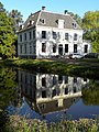
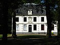
Landhuis:
|
This is a category about rijksmonument number 511494
|
Historische tuin- en parkaanleg:
|
This is a category about rijksmonument number 511496
|
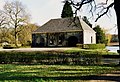
Koetshuis:
|
This is a category about rijksmonument number 511497
|
| Address |
|
Media in category "Spijkerbosch (Olst)"
The following 11 files are in this category, out of 11 total.
-
 20150706 Huis Spijkerbosch.jpg 4,896 × 3,672; 1.88 MB
-
 Huize Spykerbosch, Boskamp.jpg 1,498 × 1,998; 1.04 MB
-
 Koetshuis met twee afgeronde deuren en dakkapel - Olst - 20172977 - RCE.jpg 1,200 × 806; 204 KB
-
 Olst, Spijkerbosch hist tuin- en parkaanleg RM511496.jpg 4,461 × 3,428; 7.84 MB
-
 Olst, Spijkerbosch RM511494.jpg 3,648 × 2,736; 7.56 MB
-
 Spijkerbos.JPG 3,072 × 2,304; 840 KB
-
 Spijkerbosch anno 1611 door Gerrit Toorenburgh 1759.jpg 1,332 × 960; 388 KB
-
 Spijkerbosch koetshuis.jpg 2,148 × 1,476; 584 KB
-
 Spijkerbosch omstreeks 1730 Abraham de Haen naar Cornelis Pronk.jpg 2,210 × 1,504; 761 KB
-
 Spijkerbosch.jpg 2,153 × 1,476; 500 KB
-


