Category:Speicher im Oberbüel
Jump to navigation
Jump to search
| Object location | | View all coordinates using: OpenStreetMap |
|---|
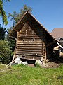
rural building in Wynigen in the canton of Bern, Switzerland  | |||||
| Upload media | |||||
| Instance of | |||||
|---|---|---|---|---|---|
| Part of | |||||
| Made from material | |||||
| Location | Oberbühl farmhouse, Wynigen, Emmental administrative district, Emmental-Oberaargau administrative region, Bern, Switzerland | ||||
| Street address |
| ||||
| Heritage designation |
| ||||
| Inception |
| ||||
 | |||||
Media in category "Speicher im Oberbüel"
The following 3 files are in this category, out of 3 total.
-
 Wynigen Oberbühl Spycher239c.jpg 3,240 × 4,320; 2.08 MB
-
 Wynigen Oberbühl Spycher239c2.jpg 3,240 × 4,320; 2 MB
-
 Wynigen Oberbühl Spycher239cDetail.jpg 3,240 × 4,320; 1.9 MB

