Category:Speicher (Hauptstrasse 21c, Worben)
Jump to navigation
Jump to search
| Object location | | View all coordinates using: OpenStreetMap |
|---|
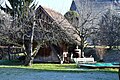
rural building from Meinisberg moved here to Worben in the canton of Bern, Switzerland  | |||||
| Upload media | |||||
| Instance of | |||||
|---|---|---|---|---|---|
| Part of | |||||
| Location |
| ||||
| Street address |
| ||||
| Heritage designation |
| ||||
| Inception |
| ||||
 | |||||
Media in category "Speicher (Hauptstrasse 21c, Worben)"
This category contains only the following file.
-
 2020-Worben-Speicher-Hauptstrasse.jpg 1,152 × 768; 351 KB