Category:Spanish exploration in the southwest, 1528 - 1543
Jump to navigation
Jump to search
Nederlands: Een vertaling van het dagboek van Juan Rodríguez Cabrillo. Aangevuld met tekeningen van deze en andere expedities. (p.5)
English: A translation of the diary of Juan Rodríguez Cabrillo. Supplemented by drawings of these and other expeditions. (P.5)
Map's
- Map of exploration on the northern frontier of New Spain 1535 - 1706s (p.front part)
- Oñate's route to New Mexico in 1508 and to the Arkansas river in 1601 (p.212)
- Leon's route in 1690 from Monclova to the Neches river (p. 370)
Media in category "Spanish exploration in the southwest, 1528 - 1543"
The following 5 files are in this category, out of 5 total.
-
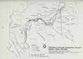
 Map The Coronado Expedition 1541 Routes in a zone of uncertainty.png 1,974 × 1,048; 1.5 MB
-
 Possible Coronado Expedition Routes as found by Bolton, Riley and Winship.png 1,822 × 1,301; 1.65 MB
-
 Possible Coronado Expedition Routes as found by Day, Donoghue and Wedel.png 1,830 × 1,293; 1.85 MB
-
 Possible Coronado Expedition Routes as found by Di Peso, Schroeder, Udall.png 1,823 × 1,300; 1.86 MB
-
 Possible Coronado Expedition Routes as found by Hodge, Holden and Sauer.png 1,796 × 1,304; 1.52 MB


Categories:
- 1916 books from the United States
- United States in the 16th century
- Spanish expeditions in North America
- History of the Viceroyalty of New Spain
- Books about the Viceroyalty of New Spain
- Books about the history of the United States
- History of the Southwestern United States
- History of indigenous peoples of the North American Southwest
- 16th-century Native American history