Category:Spacemedia NOAA files uploaded by OptimusPrimeBot
Jump to navigation
Jump to search

- Where are these files used on Wikimedia websites? (GLAMorous tool)
- Statistics (CAUTION may be slow to load)
- Search by file type
This category contains 375 files, which is 0% of all 108,437,688 files on Wikimedia Commons.
Subcategories
This category has the following 2 subcategories, out of 2 total.
Media in category "Spacemedia NOAA files uploaded by OptimusPrimeBot"
The following 200 files are in this category, out of 375 total.
(previous page) (next page)-

-
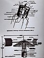
 26-meter polar-orbiting satellite antenna (2268-180).jpg 1,788 × 1,188; 1.25 MB
-
 26-meter polar-orbiting satellite antenna (2268-182).jpg 1,772 × 1,188; 1.32 MB
-
 26-meter polar-orbiting satellite antenna (2268-183).jpg 1,196 × 1,772; 1.42 MB
-
 26-meter polar-orbiting satellite antenna (2268-184).jpg 1,200 × 1,772; 1.35 MB
-
 26-meter polar-orbiting satellite antenna (2268-185).jpg 1,172 × 1,744; 1.08 MB
-
 26-meter polar-orbiting satellite antenna (2268-186).jpg 1,764 × 1,192; 1.31 MB
-
 26-meter polar-orbiting satellite antenna (2268-187).jpg 1,188 × 1,776; 1.49 MB
-

-

-

-

-

-

-
 A Mercury launch (2268-52).jpg 814 × 1,019; 497 KB
-

-
 A parabolic antenna at Wallops Island (2268-202).jpg 1,196 × 1,568; 849 KB
-
 A parabolic antenna at Wallops Island (2268-203).jpg 1,180 × 1,808; 953 KB
-

-

-

-
 A specialized satellite data receiving antenna (2268-209).jpg 1,180 × 1,640; 1.31 MB
-
 A TIROS night launch on a Thor-Delta rocket (2277-25).jpg 1,200 × 1,808; 732 KB
-

-
 A very sharp frontal system extending from Cape Cod to the Gulf of Mexico (2268-427).jpg 2,500 × 1,634; 499 KB
-

-

-

-

-
 Actinoform or radial clouds as seen by TIROS V (2282-49).jpg 1,208 × 1,176; 768 KB
-

-

-
 Adjusting television camera prior to mounting on satellite (2268-303).jpg 1,444 × 1,184; 797 KB
-

-

-

-

-

-

-
 An early GOES satellite (2268-265).jpg 1,188 × 1,652; 1.25 MB
-
 An early image from Applications Technology Satellite 1 (ATS-1) (2282-77).jpg 1,440 × 1,192; 976 KB
-

-

-
 An early TIROS satellite - later models had cameras mounted on sides (2269-10).jpg 1,676 × 1,188; 1.24 MB
-
 An early TIROS satellite - later models had cameras mounted on sides (2269-2).jpg 1,700 × 1,140; 1.16 MB
-
 An early TIROS satellite - later models had cameras mounted on sides (2269-9).jpg 1,688 × 1,188; 1.34 MB
-

-

-

-
 Applications Technology Satellite 3 (ATS-3) image of the western hemisphere (2282-78).jpg 1,200 × 1,276; 1.05 MB
-

-
 Arctic regions snow and ice over Canadian islands west of Greenland (2282-52).jpg 1,196 × 1,652; 1.11 MB
-

-

-
 Artist's conception of NIMBUS meteorological satellite system (2268-133).jpg 1,672 × 1,180; 1.45 MB
-
 Artist's conception of the AEROS meteorological satellite system (2297-16).jpg 1,764 × 1,180; 1.55 MB
-

-
 Artist's rendition of GOES D-E-F series of satellites in orbit (2268-258).jpg 1,804 × 1,184; 1.04 MB
-
 Artist's rendition of GOES D-E-F series of satellites in orbit (2268-259).jpg 1,548 × 1,148; 1,015 KB
-
 Ash plume from Alaid Volcano on Atlasova Island (2268-486).jpg 2,500 × 1,950; 352 KB
-
 ATMOSPHERE- Poster of satellite applications used in atmospheric studies (2268-525).jpg 2,016 × 2,592; 1.63 MB
-
 ATS-3 full disc image Forerunner of GOES satellite system (2268-402).jpg 2,000 × 1,519; 309 KB
-

-

-
 Calibrating the cameras on a TIROS satellite (2269-20).jpg 1,192 × 1,504; 828 KB
-
 CLIMATOLOGY- Poster of satellite applications used in climatological studies (2268-526).jpg 2,016 × 2,592; 1.71 MB
-

-
 Cloud cover in the Caribbean sea and to the north of Cuba (2268-418).jpg 2,500 × 1,606; 445 KB
-

-
 Coastal currents from northern California to Vancouver Island (2268-491).jpg 2,619 × 2,500; 767 KB
-
 Coastal currents on the California and Oregon coastline (2268-490).jpg 1,553 × 2,500; 531 KB
-
 Comparing Applications Satellite 1 (ATS-1) configuration with ATS-6 (2268-521).jpg 2,190 × 2,910; 1.08 MB
-

-
 Composite geostationary satellite image of band of Earth (2268-517).jpg 3,632 × 2,252; 862 KB
-

-
 Conceptual diagram of ATS, the Applications Technology Satellite series (2297-14).jpg 1,820 × 1,084; 913 KB
-

-

-

-
 Cut-off North Pacific low as seen on pass 129 by TIROS-9 (2268-496).jpg 2,500 × 1,274; 336 KB
-

-

-

-

-

-

-
 Diagram of NOAA GOES satellite data acquisition and distribution (2268-507).jpg 2,292 × 1,768; 389 KB
-
 Diagram of Satellite Search and Rescue (SARSAT) concept (2268-475).jpg 2,500 × 1,708; 450 KB
-

-
 Diagram of TIROS II launch sequence (2277-21).jpg 1,788 × 1,136; 1.38 MB
-

-

-

-

-
 Dust or smoke over the Yucatan Peninsula (2268-400).jpg 1,977 × 1,539; 487 KB
-
 Early polar-orbiting satellite image of a tropical cyclone (2268-19).jpg 1,236 × 1,628; 1.05 MB
-
Earth from Orbit- NOAA Satellites Celebrate Earth Day (NESDIS 2022-04-22 2022 04 22 EarthDay TWITTER).webm 2 min 16 s, 1,920 × 1,080; 150.71 MB
-

-
 Electronic equipment at the Wallops Island CDA (2268-220).jpg 1,536 × 1,176; 1.24 MB
-

-

-

-
Extreme Heat and Severe Weather Plague Parts of North America (NESDIS 2023-06-30 2023 06 30 Extreme Heat and Severe Weather UHD).webm 2 min 4 s, 3,840 × 2,160; 315.85 MB
-
 False gray scale temperature deriving heights of cloud tops (2268-428).jpg 2,500 × 1,629; 554 KB
-

-

-
 First complete view of the World's weather as seen from TIROS IX (2268-85).jpg 1,792 × 1,152; 1.53 MB
-
 First GOES-14 full disk visible image (2268-626).jpg 3,209 × 3,083; 3.8 MB
-
 First GOES-15 full disk image (2268-613).jpg 1,800 × 1,800; 873 KB
-
 First GOES-9 full disk image (2268-49).jpg 1,075 × 1,125; 751 KB
-

-

-
 Frontal system extending from the Ohio Valley to the Gulf Coast (2268-413).jpg 2,400 × 3,544; 1.22 MB
-
 Frontal systems racing across the North Pacific (2268-404).jpg 2,500 × 1,634; 595 KB
-
 Gilbert as Tropical Depression 12 in early stages of development (2268-391).jpg 2,000 × 1,571; 343 KB
-
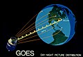 GOES day night picture distribution (2268-511).jpg 2,487 × 1,701; 275 KB
-

-

-
 GOES image of North America (2268-280).jpg 1,308 × 1,196; 1.13 MB
-
 GOES image of North America (2268-9).jpg 1,288 × 1,184; 1.11 MB
-
 GOES image of North America (2282-88).jpg 1,336 × 1,176; 1.11 MB
-

-

-

-

-

-
 GOES imagery of Hurricane Hugo passing over U S Virgin Islands (2268-435).jpg 1,893 × 1,695; 581 KB
-

-
 GOES view of North America (2282-94).jpg 1,276 × 1,192; 1.1 MB
-
 GOES view of North America (2282-95).jpg 1,292 × 1,176; 1.08 MB
-

-
 GOES-14 first visible image GOES-14 was launched June 26, 2009 (2268-553).jpg 3,209 × 3,083; 1.81 MB
-

-
GOES-R Short- Lightning.webm 16 s, 1,280 × 720; 5.82 MB
-
GOES-R Spacecraft Separation.webm 39 s, 1,280 × 720; 6.57 MB
-

-

-
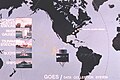
 Graphic of GOES Central Data Distribution System (2297-24).jpg 1,776 × 1,200; 1.05 MB
-
 Graphic of GOES data collection system (2297-25).jpg 1,788 × 1,188; 1.09 MB
-

-

-

-

-
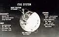
 Graphic of Improved TIROS Operational System (ITOS) satellite system data flow (2297-13).jpg 1,716 × 1,188; 1.54 MB
-
 Graphic of ITOS satellite in orbit (2269-28).jpg 1,172 × 1,224; 921 KB
-
 Graphic of ITOS satellite in orbit (2269-29).jpg 1,804 × 1,184; 1.37 MB
-

-
 Graphic of ITOS system data flow (2268-262).jpg 1,620 × 1,184; 1.05 MB
-
 Graphic of NIMBUS satellite in orbit (2268-168).jpg 1,560 × 1,160; 805 KB
-
 Graphic of overall ITOS system (2268-263).jpg 1,820 × 1,148; 1.28 MB
-
 Graphic of phenomena measured by TIROS II infrared sensors (2297-11).jpg 1,684 × 1,184; 1.03 MB
-
 Graphic of the TIROS wheel satellite (2297-6).jpg 1,948 × 1,344; 1.11 MB
-
 Graphic of TIROS II orbital path and examples of data products (2297-10).jpg 1,612 × 1,208; 1.03 MB
-
 Graphic of TIROS M, also known as ITOS-1 (2269-12).jpg 1,780 × 1,200; 1.87 MB
-
-
 Graphic of TIROS-N circling the Earth (2269-30).jpg 1,788 × 1,176; 1.13 MB
-
 Graphic of TIROS-N satellite in orbit (2269-24).jpg 1,808 × 1,180; 1.19 MB
-

-

-

-

-

-

-
 Ground communications distribution system for satellite data (2268-509).jpg 2,500 × 2,320; 733 KB
-
 HAZARDS- Poster of satellite applications for hazards observations (2268-527).jpg 2,016 × 2,592; 1.49 MB
-
 How many countries can you see in this image? (2268-480).jpg 2,500 × 2,352; 565 KB
-
 Hurricane Alma off the west coast of Florida - NIMBUS II, pass 338, APT (2268-165).jpg 1,124 × 1,384; 992 KB
-

-
 Hurricane Andrew making landfall south of Miami (2268-398).jpg 2,000 × 1,547; 475 KB
-

-
 Hurricane Betsy as photographed from TIROS VII (2268-18).jpg 1,236 × 1,184; 772 KB
-
 Hurricane Betsy as photographed from TIROS VIII (2268-16).jpg 1,196 × 1,152; 867 KB
-

-
 Hurricane Gilbert approaching the Yucatan Peninsula NOAA-10 image (2268-386).jpg 3,200 × 2,328; 1.07 MB
-
 Hurricane Gilbert in the Caribbean Sea (2268-387).jpg 2,000 × 1,455; 496 KB
-

-

-

-
 Hurricane Hugo approaching the South Carolina coast (2268-399).jpg 2,000 × 1,192; 394 KB
-
 Hurricane Hugo approaching the South Carolina coast as seen from GOES-7 (2268-518).jpg 3,528 × 2,020; 1.25 MB
-
 Hurricane Mitch imaged by GOES-8 (2277-18).jpg 1,080 × 792; 488 KB
-
 Ice cover in the Bering Sea (2268-487).jpg 2,500 × 1,823; 569 KB
-
 Ice cover in the Bering Sea (2268-489).jpg 2,500 × 3,190; 893 KB
-
 Ice cover on Hudson's Bay, Canada (2268-488).jpg 2,305 × 2,500; 614 KB
-
 Ice floes as seen in Canada's Gulf of St Lawrence as imaged by TIROS II (2282-54).jpg 1,180 × 1,592; 868 KB
-

-
 Iceland, the Denmark Strait with pack ice, and the coast of Greenland (2268-482).jpg 2,500 × 2,500; 619 KB
-

-
 Infrared image of Hurricane Gilbert approaching Jamaica GOES -7 image (2268-393).jpg 2,000 × 1,547; 500 KB
-
 Infrared image of Hurricane Gilbert while at peak intensity GOES-7 image (2268-392).jpg 2,000 × 1,547; 479 KB
-

-

-
 Infrared imagery as obtained by the Landsat satellite of upper Chesapeake Bay (2282-102).jpg 1,200 × 1,496; 1.25 MB
-
 Infrared imagery as obtained by the Landsat satellite of upper Chesapeake Bay (2282-6).jpg 1,228 × 1,196; 1.01 MB
-

-
 Infrared imagery of Gulf Stream off the Virginia Capes (2268-445).jpg 2,500 × 1,636; 565 KB
-
 Infrared imagery of Loop Current in the Gulf of Mexico (2268-444).jpg 2,664 × 1,784; 607 KB
-

-

-

.jpg)
.jpg)
.jpg)
.jpg)
.jpg)
.jpg)
.jpg)
.jpg)
.jpg)
.jpg)
.jpg)
.jpg)
.jpg)
.jpg)
.jpg)
.jpg)
.jpg)
.jpg)
.jpg)
_(2268-424).jpg)
.jpg)
.jpg)
.jpg)
.jpg)
.jpg)
.jpg)
.jpg)
_(2268-423).jpg)
.jpg)
.jpg)
.jpg)
.jpg)
.jpg)
.jpg)
.jpg)
.jpg)
.jpg)
_(2282-77).jpg)
.jpg)
.jpg)
.jpg)
.jpg)
.jpg)
.jpg)
.jpg)
_image_of_the_western_hemisphere_(2282-78).jpg)
.jpg)
.jpg)
.jpg)
.jpg)
.jpg)
.jpg)
.jpg)
.jpg)
.jpg)
.jpg)
.jpg)
.jpg)
.jpg)
.jpg)
.jpg)
.jpg)
.jpg)
.jpg)
.jpg)
.jpg)
.jpg)
_configuration_with_ATS-6_(2268-521).jpg)
.jpg)
.jpg)
.jpg)
.jpg)
.jpg)
.jpg)
.jpg)
.jpg)
.jpg)
.gif)
_(2268-620).jpg)
_parabolic_antenna_at_the_Wallops_Island_CDA_(2268-211).jpg)
.jpg)
.jpg)
.jpg)
_concept_(2268-475).jpg)
.jpg)
.jpg)
_(2268-624).jpg)
_(2268-622).jpg)
_(2268-621).jpg)
.jpg)
.jpg)
.jpg)
.jpg)
.jpg)
.jpg)
.jpg)
.jpg)
.jpg)
.jpg)
.jpg)
.jpg)
.jpg)
.jpg)
.jpg)
.jpg)
.jpg)
.jpg)
.jpg)
.jpg)
.jpg)
.jpg)
.jpg)
.jpg)
.jpg)
.jpg)
.jpg)
.jpg)
.jpg)
.jpg)
.jpg)
.jpg)
.jpg)
.jpg)
.jpg)
.jpg)
.jpg)
.jpg)

.jpg)
.jpg)
.jpg)
.jpg)
.jpg)
.jpg)
_satellite_satellite_series_orbital_parameters_and_sensors_(2297-12).jpg)
_satellite_system_data_flow_(2297-13).jpg)
.jpg)
.jpg)
.jpg)
.jpg)
.jpg)
.jpg)
.jpg)
.jpg)
.jpg)
.jpg)
.jpg)
.jpg)
.jpg)
.jpg)
Total_System_Satellite_shown_is_similar_to_early_GOES_(2297-23).jpg)
.jpg)
.jpg)
.jpg)
.jpg)
.jpg)
.jpg)
.jpg)
.jpg)
.jpg)
.jpg)
.jpg)
.jpg)
.jpg)
.jpg)
.jpg)
.jpg)
_low_A_record_barometric_low_for_the_western_hemisphere_GOES-7_image_(2268-388).jpg)
_low_A_record_barometric_low_for_the_western_hemisphere_Peak_wind_speed_of_173_knots_(almost_200_mph)_GOES-7_image_(2268-389).jpg)
.jpg)
.jpg)
.jpg)
.jpg)
.jpg)
.jpg)
.jpg)
.jpg)
,_a_frontal_band_to_the_south_(E),_andparallel_bands_of_cumuliform_clouds_to_the_east_(B)_TIROS_IX_photograph,_pass715-714,_camera_2,_frame_2_(2282-53).jpg)
.jpg)
.jpg)
.jpg)
.jpg)
.jpg)
.jpg)
.jpg)
.jpg)
.jpg)
.jpg)
.jpg)
.jpg)
.jpg)
.jpg)
_system_(2268-208).jpg)
_receiving_antenna_mounted_on_the_top_ofthe_Weather_Bureau_National_Weather_Satellite_Center_(2268-127).jpg)
.jpg)
.jpg)