Category:Sowerby-under-Cotcliffe
Jump to navigation
Jump to search
civil parish in the Hambleton district of North Yorkshire, England | |||||
| Upload media | |||||
| Instance of | |||||
|---|---|---|---|---|---|
| Location | Hambleton, North Yorkshire, Yorkshire and the Humber, England | ||||
| Population |
| ||||
 | |||||
English: Sowerby-under-Cotcliffe is a civil parish in the Hambleton district, in the county of North Yorkshire, England.
Media in category "Sowerby-under-Cotcliffe"
The following 17 files are in this category, out of 17 total.
-
 Benchmark on outbuilding at Sowerby Grange - geograph.org.uk - 5717832.jpg 683 × 1,024; 262 KB
-
 Bridge over Cod Beck - geograph.org.uk - 6444162.jpg 3,888 × 5,184; 5.19 MB
-
 Bridleway across the beck - geograph.org.uk - 2387001.jpg 2,448 × 3,264; 2.65 MB
-
 Bridleway down to the beck - geograph.org.uk - 2386996.jpg 2,448 × 3,264; 3.34 MB
-
 Bridleway to Pill Rigg farm - geograph.org.uk - 295580.jpg 640 × 427; 293 KB
-
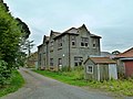
 Buildings at Sowerby Grange - geograph.org.uk - 5717846.jpg 1,024 × 683; 162 KB
-
 Cattle on camera - geograph.org.uk - 2386988.jpg 2,297 × 2,177; 1.09 MB
-
 Chester Lane - geograph.org.uk - 5371017.jpg 2,048 × 1,536; 1.06 MB
-
 Country Lane to Sowerby Grange (2) - geograph.org.uk - 6444154.jpg 4,808 × 3,530; 5.22 MB
-
 Country Lane to Sowerby Grange - geograph.org.uk - 323080.jpg 640 × 480; 150 KB
-
 Oil seed rape at Sowerby under Cotcliffe - geograph.org.uk - 2386986.jpg 3,264 × 2,448; 1.86 MB
-
 Pylons at Sowerby under Cotcliffe - geograph.org.uk - 2386992.jpg 2,448 × 3,264; 1.54 MB
-
 Runners pass Beech Dene - geograph.org.uk - 4975918.jpg 640 × 427; 114 KB
-
 Sowerby Grange (geograph 2028058).jpg 1,280 × 960; 439 KB
-
 Sowerby road - geograph.org.uk - 5375766.jpg 2,048 × 1,536; 938 KB
-
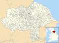 Sowerby-under-Cotcliffe UK parish locator map.svg 1,425 × 1,037; 4.3 MB
-
 Track to Pill Rigg Farm - geograph.org.uk - 6444142.jpg 5,184 × 3,888; 6.63 MB


_-_geograph.org.uk_-_6444154.jpg)


.jpg)


