Category:Southwater
Jump to navigation
Jump to search
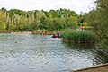
English: Southwater is a large village and civil parish in the Horsham District of West Sussex, England with a population of roughly 10,000. The village is administered from the Horsham District Council Offices. Much of the population of Southwater originated from the brick industry which thrived in the clay-pits until the 1980s. Following the closure of the brickworks, there was a project implemented to transform the area into a country park, which now stands as one of the major family attractions in the district.

village and civil parish in West Sussex, England .JPG) | |||||
| Upload media | |||||
| Instance of | |||||
|---|---|---|---|---|---|
| Location | Horsham, West Sussex, South East England, England | ||||
| Area |
| ||||
| Said to be the same as | Southwater (Wikimedia duplicated page, civil parish) | ||||
 | |||||
Subcategories
This category has the following 10 subcategories, out of 10 total.
C
- Southwater Cricket Club (108 F)
D
- Denne Park House (5 F)
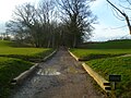
- Downs Link at Southwater (63 F)
H
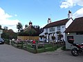
- Hen and Chicken, Southwater (3 F)
K
- Kings House, Southwater (4 F)
S
- Southwater railway station (6 F)
Media in category "Southwater"
The following 200 files are in this category, out of 460 total.
(previous page) (next page)-
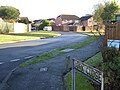
 "Parthings" on Parthings Lane - geograph.org.uk - 4849962.jpg 800 × 600; 173 KB
-
 Mobile construction crane at Southwater, West Sussex, England.jpg 2,953 × 3,937; 10.13 MB
-
 Housing construction site at Southwater, West Sussex, England.jpg 4,610 × 2,305; 7.63 MB
-
 A fallow field - geograph.org.uk - 2657400.jpg 640 × 430; 121 KB
-
 A line of three trees - geograph.org.uk - 2657403.jpg 640 × 430; 87 KB
-
 A24 - geograph.org.uk - 2672660.jpg 640 × 430; 48 KB
-
 A24 - geograph.org.uk - 6504958.jpg 1,024 × 684; 140 KB
-

-
 Aeroplane at Jackrells Farm Airfield - geograph.org.uk - 6475438.jpg 1,632 × 918; 777 KB
-
 Allendale, Southwater - geograph.org.uk - 2709778.jpg 4,320 × 3,240; 3.41 MB
-
 An entrance to Christ's Hospital - geograph.org.uk - 3346925.jpg 1,600 × 1,200; 436 KB
-
 Arun Valley line - geograph.org.uk - 2670136.jpg 640 × 430; 123 KB
-
 B2237, Boars Head - geograph.org.uk - 2955643.jpg 640 × 430; 79 KB
-
 Barns, Coltstaple Farm - geograph.org.uk - 2047032.jpg 640 × 428; 111 KB
-
 Barrack Field Crossing - geograph.org.uk - 6008854.jpg 4,160 × 3,120; 3.27 MB
-
 Barrackfield Crossing - geograph.org.uk - 2337395.jpg 1,600 × 1,200; 468 KB
-
 Bax Castle - geograph.org.uk - 3823413.jpg 640 × 480; 60 KB
-
 Bax Castle Two Mile Ash - geograph.org.uk - 569839.jpg 640 × 480; 283 KB
-
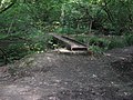
 Bench Overlooking Lake in Southwater Country Park - geograph.org.uk - 5326069.jpg 1,600 × 1,200; 322 KB
-
 Bend in Footpath - geograph.org.uk - 3350797.jpg 1,600 × 1,200; 408 KB
-
 Bend in the footpath - geograph.org.uk - 1867552.jpg 640 × 430; 188 KB
-
 Bend in the route of Bridleway BW1642 - geograph.org.uk - 3346858.jpg 1,600 × 1,200; 389 KB
-
 Bend on bridleway at Two Mile Ash - geograph.org.uk - 4850554.jpg 800 × 600; 93 KB
-
 Bends in Two Mile Ash Road - geograph.org.uk - 1417656.jpg 640 × 480; 106 KB
-
 Birchwood Cottages, built 1870 - geograph.org.uk - 2124445.jpg 640 × 428; 112 KB
-
 Birchwood Farm - geograph.org.uk - 1417366.jpg 640 × 480; 73 KB
-
 Blinks Wood - geograph.org.uk - 1417219.jpg 640 × 480; 157 KB
-
 Bourne Hill and Horsham from the air - geograph.org.uk - 5151036.jpg 2,048 × 1,098; 598 KB
-

-

-

-
 Bridleway BW1670 - geograph.org.uk - 3201188.jpg 3,474 × 2,998; 3.24 MB
-
 Bridleway BW3568-1 - geograph.org.uk - 3215990.jpg 4,000 × 3,000; 4.39 MB
-

-
 Bridleway reaches Two Mile Ash Road - geograph.org.uk - 4850557.jpg 800 × 600; 117 KB
-
 Bridleway to Southwater - geograph.org.uk - 1418075.jpg 640 × 480; 130 KB
-
 Bridleway to Stakers Farm - geograph.org.uk - 1419214.jpg 640 × 480; 90 KB
-
 Bridleway west of Marlpost Farm - geograph.org.uk - 1417429.jpg 640 × 480; 138 KB
-
 Building on Station Rd - geograph.org.uk - 2672435.jpg 640 × 430; 113 KB
-

-

-

-
 Byway crosses golf course - geograph.org.uk - 4850091.jpg 800 × 600; 146 KB
-
 Byway Junction - geograph.org.uk - 3201117.jpg 4,000 × 3,000; 4.76 MB
-
 Canoe class, Southwater Country Park - geograph.org.uk - 4362961.jpg 640 × 428; 122 KB
-
 Canoe class, Southwater Country Park - geograph.org.uk - 4362970.jpg 640 × 428; 118 KB
-
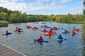 Canoe class, Southwater Country Park - geograph.org.uk - 4362976.jpg 640 × 428; 109 KB
-

-
 Cattle in a field - geograph.org.uk - 2656418.jpg 640 × 430; 81 KB
-
 Cattle sheds near Little Coltstaple Farm - geograph.org.uk - 1418709.jpg 640 × 480; 112 KB
-
 Cattle, Denne Park - geograph.org.uk - 1291977.jpg 640 × 430; 112 KB
-
-
 Cedar Drive, Southwater - geograph.org.uk - 68875.jpg 640 × 479; 223 KB
-
 Chewing the cud - geograph.org.uk - 4363260.jpg 640 × 428; 126 KB
-
 Christ's Hospital from the air - geograph.org.uk - 5151062.jpg 2,048 × 1,195; 687 KB
-
 Christ's Hospital Rd - geograph.org.uk - 2956977.jpg 640 × 430; 101 KB
-

-
 Christ's Hospital Road - geograph.org.uk - 2709751.jpg 4,320 × 3,240; 4.7 MB
-
 Christ's Hospital Road - geograph.org.uk - 2709771.jpg 4,320 × 3,240; 3.87 MB
-
 Christ's Hospital Road, Christ's Hospital, West Sussex - geograph.org.uk - 2245998.jpg 1,600 × 1,200; 490 KB
-
 Christ's Hospital school on the horizon - geograph.org.uk - 1867548.jpg 640 × 430; 142 KB
-
 Christ's Hospital, country road junction - geograph.org.uk - 4543954.jpg 1,600 × 1,200; 446 KB
-
 Church Lane Southwater - geograph.org.uk - 2661974.jpg 4,000 × 3,000; 3.45 MB
-
 Church Room - geograph.org.uk - 437459.jpg 640 × 480; 69 KB
-
 Clump of trees at Denne Park - geograph.org.uk - 6475465.jpg 4,606 × 2,591; 2.39 MB
-
 College Farm - geograph.org.uk - 2645731.jpg 640 × 430; 64 KB
-
 College Farm - geograph.org.uk - 2645732.jpg 640 × 430; 62 KB
-
 College Farm Track - geograph.org.uk - 2645733.jpg 640 × 430; 78 KB
-
 Coltstaple farmhouse - roof, chimneys and weather vane - geograph.org.uk - 6475514.jpg 4,202 × 2,363; 2.18 MB
-
 Coltstaple Lane - geograph.org.uk - 3201175.jpg 4,000 × 3,000; 4.17 MB
-
 Coltstaple Lane at Beckley Farm - geograph.org.uk - 4850068.jpg 800 × 600; 160 KB
-

-
 Coltstaple Lane near Horsham - geograph.org.uk - 3330827.jpg 1,600 × 1,286; 678 KB
-
 Coltstaple Lane near Horsham - geograph.org.uk - 3330834.jpg 800 × 600; 257 KB
-
 Cottage name in quiet neighbourhood^ - geograph.org.uk - 1417672.jpg 640 × 480; 147 KB
-
 Cottage near Denne Park - geograph.org.uk - 2029219.jpg 640 × 480; 88 KB
-
 Courtlands Wood - geograph.org.uk - 2656477.jpg 640 × 430; 95 KB
-
 Courts, Christ's Hospital School - geograph.org.uk - 2672387.jpg 640 × 430; 93 KB
-

-
 Cripplegate Lane - geograph.org.uk - 2644117.jpg 640 × 430; 74 KB
-
 Cripplegate Lane - geograph.org.uk - 2644120.jpg 640 × 430; 103 KB
-
 Cripplegate Lane with Country Park sign - geograph.org.uk - 5222770.jpg 800 × 600; 182 KB
-
 Cyclists on New Year's Day near Horsham - geograph.org.uk - 3330833.jpg 1,600 × 1,195; 549 KB
-
 Demolition of Kirby's - geograph.org.uk - 3346893.jpg 1,600 × 1,200; 422 KB
-
 Denne Park House - geograph.org.uk - 6475476.jpg 4,372 × 2,459; 2.17 MB
-

-
 East Lodge - geograph.org.uk - 3346902.jpg 1,600 × 1,200; 452 KB
-

-
 Entrance to Hop Oast Farm - geograph.org.uk - 5791867.jpg 640 × 480; 141 KB
-
 Entrance to Lanaways Farm - geograph.org.uk - 4850565.jpg 800 × 600; 142 KB
-
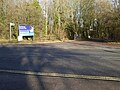 Entrance to Southwater Country Park - geograph.org.uk - 5222767.jpg 800 × 600; 182 KB
-

-
 Entry to Southwater - geograph.org.uk - 3295410.jpg 1,600 × 1,042; 318 KB
-
 Everlasting footbridge in Nutham Wood - geograph.org.uk - 1419240.jpg 640 × 480; 117 KB
-
 Exposed tree roots - geograph.org.uk - 237438.jpg 640 × 590; 513 KB
-

-

-
 Farmland by the Downs Link - geograph.org.uk - 2656399.jpg 640 × 430; 100 KB
-
 Farmland by the Downs Link - geograph.org.uk - 2656486.jpg 640 × 430; 76 KB
-
 Farmland by the Downs Link - geograph.org.uk - 2657401.jpg 640 × 430; 95 KB
-
 Farmland by the railway line - geograph.org.uk - 2672661.jpg 640 × 430; 59 KB
-
 Farmland near Horsham - geograph.org.uk - 4764708.jpg 640 × 426; 32 KB
-

-
 Field by Downs Link - geograph.org.uk - 2644113.jpg 640 × 430; 87 KB
-

-
 Field End Cottage - geograph.org.uk - 3346897.jpg 1,600 × 1,200; 281 KB
-
 Field entrance on Kerves Lane near Horsham - geograph.org.uk - 3331742.jpg 1,024 × 935; 322 KB
-
 Field next to the cricket ground - geograph.org.uk - 2184549.jpg 640 × 480; 104 KB
-
 Fields near Southwater - geograph.org.uk - 4365192.jpg 640 × 428; 91 KB
-
 Fingerpost - geograph.org.uk - 3346941.jpg 1,600 × 1,200; 581 KB
-
 Fingerpost along public Bridleway BW1642 - geograph.org.uk - 3346855.jpg 1,600 × 1,200; 279 KB
-
 Fingerpost along Public Footpath FP1628-3 - geograph.org.uk - 3346949.jpg 1,600 × 1,200; 289 KB
-
 Fingerpost along Public Footpath FP1637 - geograph.org.uk - 3346926.jpg 1,600 × 1,200; 509 KB
-
 Fingerpost on Public Footpath FP1628-3 - geograph.org.uk - 3350790.jpg 1,600 × 1,200; 408 KB
-
 Footbridge on path 1628-3 - geograph.org.uk - 2338769.jpg 480 × 640; 186 KB
-
 Footbridge on Public Footpath FP1628-3 - geograph.org.uk - 3346934.jpg 1,600 × 1,200; 609 KB
-
 Footbridge over railway - geograph.org.uk - 5790826.jpg 1,024 × 768; 371 KB
-
 Footbridges, fields south of Hop Oast Farm, 2010 - geograph.org.uk - 5792539.jpg 1,024 × 768; 499 KB
-
 Footpath 1637 - geograph.org.uk - 5895982.jpg 1,024 × 768; 508 KB
-
 Footpath 1637 - geograph.org.uk - 5895998.jpg 1,024 × 768; 393 KB
-
 Footpath 1637 - geograph.org.uk - 5896009.jpg 1,024 × 768; 487 KB
-
 Footpath 1637 - geograph.org.uk - 5896018.jpg 1,024 × 768; 490 KB
-
 Footpath 1637 crosses the A24 - geograph.org.uk - 5896026.jpg 1,024 × 768; 420 KB
-
 Footpath 1637 meets Christ's Hospital Road - geograph.org.uk - 5896030.jpg 1,024 × 768; 445 KB
-
 Footpath and Gate near Chesworth Farm - geograph.org.uk - 5745442.jpg 4,896 × 3,672; 5.65 MB
-
 Footpath approaches T junction - geograph.org.uk - 5227508.jpg 800 × 600; 155 KB
-
 Footpath arrives at Little Bridges Close - geograph.org.uk - 5222837.jpg 800 × 600; 179 KB
-
 Footpath arrives at Marlpost Road - geograph.org.uk - 5227527.jpg 800 × 600; 187 KB
-
 Footpath crosses Andrews Road - geograph.org.uk - 5222764.jpg 800 × 600; 223 KB
-

-
 Footpath crossroads - geograph.org.uk - 2645879.jpg 640 × 430; 127 KB
-
 Footpath enters woodland in Denne Park - geograph.org.uk - 4850026.jpg 800 × 600; 175 KB
-
 Footpath FP1663 - geograph.org.uk - 3201223.jpg 4,000 × 3,000; 4.81 MB
-
 Footpath FP1666 - geograph.org.uk - 3201126.jpg 4,000 × 3,000; 4.82 MB
-
 Footpath FP1676 - geograph.org.uk - 3201132.jpg 4,000 × 3,000; 4.55 MB
-
 Footpath FP1676 - geograph.org.uk - 3201150.jpg 640 × 480; 138 KB
-
 Footpath FP1887 - geograph.org.uk - 3179308.jpg 3,141 × 2,000; 1.13 MB
-

-
 Footpath goes north from stile - geograph.org.uk - 5222950.jpg 800 × 600; 208 KB
-
 Footpath goes southwards on farm road - geograph.org.uk - 5227511.jpg 800 × 600; 157 KB
-

-

-
-
 Footpath junction on Jackrells Lane - geograph.org.uk - 5222918.jpg 800 × 600; 199 KB
-
 Footpath Junction Sign, Horsham - geograph.org.uk - 5745439.jpg 4,896 × 3,672; 5.82 MB
-
 Footpath junction, Stammerham - geograph.org.uk - 5895965.jpg 1,024 × 768; 477 KB
-
 Footpath leads off Little Bridges Close - geograph.org.uk - 5222829.jpg 800 × 600; 193 KB
-
 Footpath NE to Little Stammerham Farm - geograph.org.uk - 1417689.jpg 640 × 480; 158 KB
-

-

-
 Footpath sign, Nutham Wood - geograph.org.uk - 2644044.jpg 640 × 430; 150 KB
-
 Footpath SW of Bourne Hill House - geograph.org.uk - 6475507.jpg 4,506 × 2,535; 2.84 MB
-
 Footpath to Two Mile Ash Road - geograph.org.uk - 2125749.jpg 640 × 428; 181 KB
-
 Footpath, Chesworth Farm - geograph.org.uk - 5745437.jpg 4,896 × 3,672; 5.8 MB
-
 Footpath, Sparrow Copse - geograph.org.uk - 5895865.jpg 1,024 × 768; 520 KB
-
 Fred Flintstone - as a straw man - geograph.org.uk - 6475525.jpg 3,456 × 3,455; 3.88 MB
-
 Godfreys of Horsham - geograph.org.uk - 2580525.jpg 1,600 × 1,200; 568 KB
-
 Godfreys of Horsham, Worthing Road, Southwater - geograph.org.uk - 2709783.jpg 4,320 × 3,240; 3.59 MB
-
 Grazing land and view to South Downs - geograph.org.uk - 1418234.jpg 640 × 480; 104 KB
-
 Great House Farm - geograph.org.uk - 2645886.jpg 640 × 430; 68 KB
-
 Great House Farm - geograph.org.uk - 2645887.jpg 640 × 430; 70 KB
-
 Great House Farm - geograph.org.uk - 2656391.jpg 640 × 430; 85 KB
-
 Haymaking on Stakers Farm - geograph.org.uk - 1419062.jpg 640 × 480; 78 KB
-
 Heavy cloud over grazing land - geograph.org.uk - 1418215.jpg 640 × 480; 92 KB
-
 Hedgerow oak - geograph.org.uk - 2123598.jpg 640 × 428; 111 KB
-

-
 Hill Top Cottage with pond in foreground - geograph.org.uk - 4850023.jpg 800 × 600; 163 KB
-

-

-

-
 Holy Innocents, Southwater, vicarage - geograph.org.uk - 4754802.jpg 640 × 480; 79 KB
-

-
 Hop Oast Farm, 2010 - geograph.org.uk - 5792404.jpg 1,024 × 768; 360 KB
-
 Hop Oast park and ride, Horsham - geograph.org.uk - 5791834.jpg 1,024 × 768; 315 KB
-
 Horses to the SE of Denne Hill - geograph.org.uk - 6475496.jpg 1,632 × 918; 580 KB
-
 Horsham, south of the railway - geograph.org.uk - 4580746.jpg 1,024 × 732; 1.06 MB
-
 House at Blackwater Farm - geograph.org.uk - 6475445.jpg 1,562 × 877; 597 KB
-
 House at Denne Park - geograph.org.uk - 6475463.jpg 1,414 × 1,060; 852 KB
-
 House at Little Stammerham Farm - geograph.org.uk - 5227516.jpg 800 × 600; 131 KB
-
 House at the junction of Coltstaple Lane and Broadwater Lane - geograph.org.uk - 6473156.jpg 3,856 × 2,169; 2.19 MB
-
 House by the Pedlar's Way - geograph.org.uk - 6475460.jpg 1,633 × 918; 829 KB
-
 House on King Edward Rd - geograph.org.uk - 2672379.jpg 640 × 410; 115 KB
-
 House to the east of Coltstaple Farm - geograph.org.uk - 6473162.jpg 3,438 × 1,933; 2.07 MB
-
 House to the south of Coltstaple Lane - geograph.org.uk - 6475410.jpg 4,144 × 2,066; 2.15 MB
-
 House, Christ's Hospital - geograph.org.uk - 2672437.jpg 640 × 430; 96 KB
-
 House, Christ's Hospital Rd - geograph.org.uk - 2672417.jpg 640 × 430; 118 KB
-
 House, King Edward Rd - geograph.org.uk - 2672385.jpg 640 × 430; 125 KB
-
 Houses at Christ's Hospital School - geograph.org.uk - 2956966.jpg 640 × 430; 49 KB
-
 Houses, Christ's Hospital - geograph.org.uk - 2955658.jpg 640 × 430; 40 KB
-
 Housing at Christ's Hospital - geograph.org.uk - 2672615.jpg 640 × 430; 78 KB
-
 Housing on Bluecoat Pond (road) - geograph.org.uk - 5895851.jpg 1,024 × 768; 250 KB
-
 Industrial unit through the trees - geograph.org.uk - 2644168.jpg 640 × 430; 136 KB
-
 Industrial unit, Station Rd - geograph.org.uk - 2672614.jpg 640 × 430; 85 KB
-
 Infirmary Drive, Christ's Hospital - geograph.org.uk - 2246006.jpg 1,600 × 1,200; 636 KB
-
 Itchingfield foot crossing - geograph.org.uk - 4361507.jpg 428 × 640; 160 KB
-
 Itchingfield foot crossing - geograph.org.uk - 4361512.jpg 640 × 428; 124 KB
-
 Itchingfield foot crossing - geograph.org.uk - 4361516.jpg 640 × 428; 143 KB
-
 Jackrells Lane goes north from stream - geograph.org.uk - 5222958.jpg 800 × 600; 205 KB
-
 Jackrells Lane goes south from stream - geograph.org.uk - 5222956.jpg 800 × 600; 185 KB
-
 Jackrells Lane going north - geograph.org.uk - 5222910.jpg 800 × 600; 121 KB


_-_geograph.org.uk_-_5895851.jpg)


