Category:Southport and Cheshire Lines Extension Railway
Jump to navigation
Jump to search
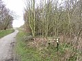
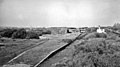
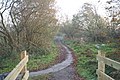
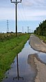
English: The Southport & Cheshire Lines Extension Railway is a now-disused railway line in Merseyside, England. It was built by the Cheshire Lines Committee, extending the North Liverpool Extension Line to Southport in 1884.

UK railway company | |||||
| Upload media | |||||
| Instance of | |||||
|---|---|---|---|---|---|
| Location | Lancashire, North West England, England | ||||
| |||||
Subcategories
This category has the following 2 subcategories, out of 2 total.
N
S
Media in category "Southport and Cheshire Lines Extension Railway"
The following 14 files are in this category, out of 14 total.
-
 Barton Spur - geograph.org.uk - 828865.jpg 640 × 480; 112 KB
-
 Birkdale Palace Station (remnants) - geograph.org.uk - 1801546.jpg 640 × 356; 107 KB
-
 Cheshire Lines path, near Lydiate - geograph.org.uk - 1411677.jpg 640 × 426; 86 KB
-
 Disused railway bridge crossing the River Alt, Sefton.jpg 3,240 × 4,320; 3.92 MB
-
 Downholland Brook - geograph.org.uk - 828845.jpg 640 × 480; 39 KB
-
 Former railway line to Southport, now the Coastal Road (geograph 6605163).jpg 1,600 × 1,200; 518 KB
-
 Into the wilderness - geograph.org.uk - 81407.jpg 640 × 426; 173 KB
-
 Lydiate Station Road - geograph.org.uk - 1411679.jpg 640 × 426; 85 KB
-
 Moss Bridge, Downholland Moss - geograph.org.uk - 509381.jpg 640 × 426; 40 KB
-

-
 Plex Moss Lane - geograph.org.uk - 828828.jpg 480 × 640; 51 KB
-
 Still Water - geograph.org.uk - 114311.jpg 640 × 480; 116 KB
-
 The Trans-Pennine Trail at Maghull - geograph.org.uk - 531080.jpg 360 × 640; 217 KB
-
 Trans-Pennine Trail - geograph.org.uk - 829849.jpg 640 × 480; 88 KB

_-_geograph.org.uk_-_1801546.jpg)


.jpg)


