Category:South Branch Mountain (West Virginia)
Jump to navigation
Jump to search
| Object location | | View all coordinates using: OpenStreetMap |
|---|
mountain in West Virginia, United States of America  | |||||
| Upload media | |||||
| Instance of | |||||
|---|---|---|---|---|---|
| Part of |
| ||||
| Location | West Virginia | ||||
| Elevation above sea level |
| ||||
 | |||||
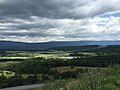
English: South Branch Mountain is a continuous mountain ridge that runs northeast through Hampshire and Hardy counties in the Potomac Highlands region of the U.S. state of West Virginia. Rising to its greatest elevation of 3,038 feet (926 m), South Branch Mountain is a folded mountain ridge, belonging to the Ridge-and-Valley Appalachians. It is also known as Jersey Mountain.
Subcategories
This category has the following 2 subcategories, out of 2 total.
T
Media in category "South Branch Mountain (West Virginia)"
The following 5 files are in this category, out of 5 total.
-
-

-

-
 Clifford Hollow Bridge aerial 2021.jpg 6,240 × 4,160; 7 MB
-
 South Branch Potomac River Millesons Mill WV 2007 05 07 08.jpg 1,536 × 2,048; 1.03 MB
_near_Fish_Pond_Road_in_western_Hardy_County,_West_Virginia.jpg)
_near_Fish_Pond_Road_in_western_Hardy_County,_West_Virginia.jpg)

_near_Fish_Pond_Road_in_western_Hardy_County,_West_Virginia.jpg)