Category:Souter Lighthouse
Jump to navigation
Jump to search
lighthouse   | |||||
| Upload media | |||||
| Instance of | |||||
|---|---|---|---|---|---|
| Made from material | |||||
| Location | Marsden, South Tyneside, Tyne and Wear, North East England, England | ||||
| Architect | |||||
| Owned by | |||||
| Operator |
| ||||
| Maintained by | |||||
| Has part(s) |
| ||||
| Heritage designation |
| ||||
| Service entry |
| ||||
| Service retirement |
| ||||
| Inception |
| ||||
| Height |
| ||||
| official website | |||||
 | |||||
Media in category "Souter Lighthouse"
The following 90 files are in this category, out of 90 total.
-
 029283-Whitburn shipping Souter Point Lighthouse C.1900.jpg 1,024 × 749; 300 KB
-
 062852-Souter Lighthouse South Shields.jpg 1,024 × 749; 507 KB
-

-

-
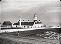
 ELLIOT(1875) p144 Fig.10 - General view of establishment at Souter Point.jpg 1,597 × 1,208; 989 KB
-
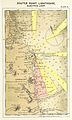 ELLIOT(1875) p145 - Plate IX. Souter Point, chart of vicinity.jpg 1,448 × 2,404; 2.23 MB
-
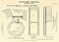 ELLIOT(1875) p149 - Plate X. Souter Point, plan and details of low light-room.jpg 1,926 × 1,368; 1.18 MB
-
 ELLIOT(1875) p151- Plate XI. Souter Point, plan of machine-room.jpg 1,380 × 2,526; 1.25 MB
-
 ELLIOT(1875) p154 Fig.11 - Lens and lanterns, Sonter Point.jpg 1,358 × 1,554; 803 KB
-
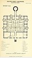
 ELLIOT(1875) p155 - Plate XII. Souter Point, general plan.jpg 1,934 × 1,388; 1,011 KB
-
 ELLIOT(1875) p157 - Plate XIII. Souter point, ground plan.jpg 1,404 × 2,532; 1.13 MB
-

-
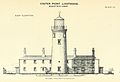 ELLIOT(1875) p163 - Plate XV. Souter Point, east elevation.jpg 2,053 × 1,404; 1,015 KB
-
 500px photo (140471385).jpeg 2,048 × 1,365; 773 KB
-
 Boldon - Souter Lighthouse 2.jpg 640 × 480; 90 KB
-
-
 Christmas at Souter - geograph.org.uk - 94972.jpg 640 × 375; 54 KB
-
 Coastal Footpath to Souter Lighthouse - geograph.org.uk - 1774869.jpg 3,648 × 2,736; 1.71 MB
-
 Footpath to Souter Lighthouse - geograph.org.uk - 2861361.jpg 1,500 × 1,000; 142 KB
-
 Footpath to Souter Lighthouse - geograph.org.uk - 2870058.jpg 1,500 × 1,000; 182 KB
-
 Lighthouse in Whitburn UK.jpeg 800 × 600; 62 KB
-
 Lighthouse Lantern - geograph.org.uk - 590553.jpg 480 × 640; 105 KB
-

-
 Looking down to Souter Lighthouse - geograph.org.uk - 590549.jpg 480 × 640; 57 KB
-
 Looking south from Souter Lighthouse - geograph.org.uk - 5123100.jpg 5,346 × 2,968; 1.58 MB
-
 Low tide below the car park at Souter Lighthouse - geograph.org.uk - 2409418.jpg 1,280 × 960; 304 KB
-

-
 Path to Souter Lighthouse - geograph.org.uk - 3273177.jpg 480 × 640; 66 KB
-
 Scrubland south of Souter Lighthouse - geograph.org.uk - 2449746.jpg 1,759 × 1,154; 179 KB
-
 Souter and the sunderland airshow - panoramio.jpg 3,872 × 2,592; 305 KB
-
 Souter Lighthouse (33652330591).jpg 5,983 × 3,624; 6.73 MB
-
 Souter Lighthouse (48586398047).jpg 5,184 × 3,888; 2.5 MB
-
 Souter Lighthouse - geograph.org.uk - 1188933.jpg 424 × 640; 274 KB
-
 Souter lighthouse - geograph.org.uk - 1417723.jpg 640 × 480; 53 KB
-
 Souter Lighthouse - geograph.org.uk - 1774910.jpg 3,648 × 2,736; 1.68 MB
-
 Souter Lighthouse - geograph.org.uk - 1959693.jpg 2,592 × 1,944; 1.26 MB
-
 Souter Lighthouse - geograph.org.uk - 209095.jpg 640 × 480; 46 KB
-
 Souter Lighthouse - geograph.org.uk - 2152438.jpg 1,024 × 768; 127 KB
-
 Souter Lighthouse - geograph.org.uk - 2367737.jpg 1,595 × 1,171; 373 KB
-
 Souter Lighthouse - geograph.org.uk - 2460744.jpg 640 × 480; 101 KB
-
 Souter Lighthouse - geograph.org.uk - 2460746.jpg 480 × 640; 40 KB
-
 Souter Lighthouse - geograph.org.uk - 2460751.jpg 640 × 480; 43 KB
-
 Souter Lighthouse - geograph.org.uk - 2460758.jpg 640 × 480; 88 KB
-
 Souter lighthouse - geograph.org.uk - 2473208.jpg 4,288 × 3,216; 226 KB
-
 Souter Lighthouse - geograph.org.uk - 258198.jpg 640 × 417; 56 KB
-
 Souter Lighthouse - geograph.org.uk - 2778432.jpg 427 × 640; 240 KB
-
 Souter Lighthouse - geograph.org.uk - 2856873.jpg 1,500 × 1,000; 114 KB
-
 Souter Lighthouse - geograph.org.uk - 2859838.jpg 1,500 × 1,000; 128 KB
-
 Souter Lighthouse - geograph.org.uk - 2859840.jpg 994 × 1,500; 97 KB
-
 Souter Lighthouse - geograph.org.uk - 2859842.jpg 1,000 × 1,500; 82 KB
-
 Souter Lighthouse - geograph.org.uk - 308790.jpg 640 × 427; 58 KB
-
 Souter Lighthouse - geograph.org.uk - 3273176.jpg 640 × 480; 82 KB
-
 Souter Lighthouse - geograph.org.uk - 5832.jpg 480 × 640; 45 KB
-
 Souter Lighthouse - geograph.org.uk - 769703.jpg 640 × 480; 57 KB
-
 Souter Lighthouse - Marsden UK.jpg 1,024 × 980; 500 KB
-
 Souter Lighthouse - panoramio.jpg 4,288 × 3,216; 3.55 MB
-

-
 Souter lighthouse and fog horn. - geograph.org.uk - 496561.jpg 640 × 481; 74 KB
-
 Souter lighthouse and Fog warning station - geograph.org.uk - 2409412.jpg 1,280 × 960; 304 KB
-
 Souter lighthouse and foghorn - geograph.org.uk - 2473228.jpg 1,024 × 768; 96 KB
-
 Souter Lighthouse and Foghorn House.jpg 4,032 × 3,024; 2.87 MB
-
 Souter Lighthouse arc light mechanism.jpg 3,024 × 5,376; 4.51 MB
-
 Souter Lighthouse battery room.jpg 3,024 × 4,032; 2.53 MB
-
 Souter Lighthouse closed for renovation - geograph.org.uk - 5154212.jpg 1,229 × 1,858; 470 KB
-
 Souter Lighthouse Engine Room 2.jpg 3,024 × 4,032; 4.11 MB
-
 Souter Lighthouse Engine Room 3.jpg 4,032 × 3,024; 3.07 MB
-
 Souter Lighthouse Engine Room.jpg 3,024 × 5,376; 4.47 MB
-
 Souter Lighthouse from the East - geograph.org.uk - 162194.jpg 640 × 482; 53 KB
-
 Souter Lighthouse from the north - geograph.org.uk - 3234665.jpg 2,048 × 1,472; 729 KB
-
 Souter Lighthouse from the side.jpg 3,096 × 4,128; 570 KB
-
 Souter Lighthouse generator.jpg 2,657 × 3,398; 3.03 MB
-
 Souter Lighthouse incandescent oil burner.jpg 3,024 × 5,376; 4.39 MB
-
 Souter Lighthouse lamp cupboard.jpg 3,024 × 4,032; 2.93 MB
-
 Souter Lighthouse lenses.jpg 3,024 × 4,032; 3.03 MB
-
 Souter Lighthouse radio beacon and weight tube.jpg 3,024 × 4,032; 2.23 MB
-
 Souter LightHouse View South.jpg 2,048 × 1,536; 1,019 KB
-
 Souter Lighthouse, General Plan (11110162384).jpg 2,272 × 1,291; 388 KB
-
 Souter Lighthouse, Horn house - geograph.org.uk - 2460750.jpg 480 × 640; 40 KB
-
 Souter Lighthouse, inside the optic.jpg 3,024 × 5,376; 4.59 MB
-
 Souter lighthouse, main optic.jpg 5,376 × 3,024; 4.66 MB
-
 Souter Lighthouse, Marsden, Tyne and Wear 2.jpeg 2,816 × 2,112; 2.51 MB
-
 Souter Lighthouse, Marsden, Tyne and Wear.jpeg 1,056 × 1,408; 115 KB
-
 Souter Lighthouse, optic and pedestal.jpg 3,024 × 5,376; 4.47 MB
-
 Souter Lighthouse, subsidiary lenses.jpg 3,024 × 5,376; 4.11 MB
-
 Souter lighthouse... (1251464282).jpg 1,600 × 1,119; 265 KB
-
 Souter Point Lighthouse between the rivers Tyne and Wear - Illustrated Times 1871.jpg 1,893 × 2,007; 2.94 MB
-
 Souterlighthouse.jpg 3,248 × 2,160; 2.44 MB
-
 The Souter Lighthouse station - geograph.org.uk - 2367758.jpg 1,767 × 1,283; 486 KB
-
 View from Souter Lighthouse car park - geograph.org.uk - 2367749.jpg 1,739 × 1,221; 572 KB
-
 Whitburn Colliery and Souter Lighthouse (10291089805).jpg 1,098 × 1,391; 194 KB


.jpg)
.jpg)
_p144_Fig.10_-_General_view_of_establishment_at_Souter_Point.jpg)
_p145_-_Plate_IX._Souter_Point,_chart_of_vicinity.jpg)
_p149_-_Plate_X._Souter_Point,_plan_and_details_of_low_light-room.jpg)
_p151-_Plate_XI._Souter_Point,_plan_of_machine-room.jpg)
_p154_Fig.11_-_Lens_and_lanterns,_Sonter_Point.jpg)
_p155_-_Plate_XII._Souter_Point,_general_plan.jpg)
_p157_-_Plate_XIII._Souter_point,_ground_plan.jpg)
_p161_-_Plate_XIV._Souter_Point,_section_of_lantern,_lens,_and_low_light-room.jpg)
_p163_-_Plate_XV._Souter_Point,_east_elevation.jpg)
.jpeg)


_-_geograph.org.uk_-_498753.jpg)


.jpg)
.jpg)


.jpg)


.jpg)


.jpg)
Categories:
- Lighthouses in Tyne and Wear
- National Trust properties in Tyne and Wear
- Listed lighthouses in England
- Lighthouses in England by name
- Museums in Tyne and Wear
- Brick lighthouses in the United Kingdom
- Inactive lighthouses in the United Kingdom
- Lighthouses built in 1871
- Lighthouses by height, 21 to 30 meters
- Boldon (unparished area)
- Lighthouses built by James Nicholas Douglass
- Red and white lighthouses in the United Kingdom
- Lighthouses by range, 25 to 29 nm
- Landfall lights in the United Kingdom
- Lighthouses with first order Fresnel lenses
- Lighthouse museums in the United Kingdom
- Lighthouse equipment by Frederick Hale Holmes
- Grade II* listed buildings in Tyne and Wear
- Chance Brothers lighthouse lights