Category:Somerset Place, North Carolina
Jump to navigation
Jump to search
|
This is a category about a place or building that is listed on the National Register of Historic Places in the United States of America. Its reference number is 70000481. |
| Object location | | View all coordinates using: OpenStreetMap |
|---|
human settlement in United States of America  | |||||
| Upload media | |||||
| Instance of | |||||
|---|---|---|---|---|---|
| Location | Washington County, North Carolina | ||||
| Heritage designation |
| ||||
 | |||||
Media in category "Somerset Place, North Carolina"
The following 8 files are in this category, out of 8 total.
-
 Coast watch (1979) (20471258480).jpg 1,274 × 1,954; 937 KB
-
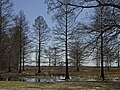 Lake Phelps from Somerset.jpg 3,648 × 2,736; 8.21 MB
-
 Somerset Place main house.jpg 3,648 × 2,736; 7.78 MB
-
 SomersetPlace.jpg 500 × 375; 130 KB
-
 Sommer Set Plantation Slave Kitchen.jpg 2,500 × 1,650; 3.45 MB
-
 Sommer Set Plantation Slave Kitchen1.jpg 2,500 × 1,650; 3.08 MB
-
 Sommer Set Plantation Slave Quarters 2.jpg 2,500 × 1,650; 3.99 MB
-
 Sommer Set Plantation.jpg 2,500 × 1,650; 4.84 MB
_(20471258480).jpg)


