Category:Slot Well
Jump to navigation
Jump to search
| Object location | | View all coordinates using: OpenStreetMap |
|---|
 | |||||
| Upload media | |||||
| Instance of | |||||
|---|---|---|---|---|---|
| Part of | |||||
| Location | Well, Maasdriel, Gelderland, Netherlands | ||||
| Street address |
| ||||
| Located on street |
| ||||
| Heritage designation |
| ||||
 | |||||
|
This is a category about rijksmonumentcomplex number 529088
|
kasteel:
|
This is a category about rijksmonument number 529089
|
historische tuin- en parkaanleg
|
This is a category about rijksmonument number 529090
|
poortgebouw:
|
This is a category about rijksmonument number 529091
|
koetshuis:
|
This is a category about rijksmonument number 529092
|
houten brug:
|
This is a category about rijksmonument number 529093
|
valbrug:
|
This is a category about rijksmonument number 529094
|
hekken:
|
This is a category about rijksmonument number 529095
|
waterpomp:
|
This is a category about rijksmonument number 529098
|
natuurstenen leeuw:
|
This is a category about rijksmonument number 529099
|
| Address |
|
Media in category "Slot Well"
The following 36 files are in this category, out of 36 total.
-
 Exterieur - Well - 20252947 - RCE.jpg 2,940 × 2,086; 3.16 MB
-
 Exterieur AANGETAST METSELWERK - Well - 20276254 - RCE.jpg 3,366 × 2,244; 3.73 MB
-
 Exterieur ACHTERGEVEL, INGANGSPARTIJ - Well - 20276253 - RCE.jpg 1,200 × 800; 294 KB
-
 Exterieur ACHTERGEVEL, POMP - Well - 20276252 - RCE.jpg 2,244 × 3,366; 3.24 MB
-
 Exterieur OVERZICHT ACHTERGEVEL - Well - 20276251 - RCE.jpg 800 × 1,200; 312 KB
-
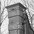
 Exterieur OVERZICHT TOEGANGSHEK MET HARDSTENEN HEKPIJLERS - Well - 20312361 - RCE.jpg 1,198 × 1,200; 498 KB
-
 Exterieur OVERZICHT TOEGANGSHEK MET HARDSTENEN PIJLERS - Well - 20312362 - RCE.jpg 1,179 × 1,200; 514 KB
-
 Exterieur TOEGANGSHEK, HARDSTENEN HEKPIJLER - Well - 20312363 - RCE.jpg 1,191 × 1,200; 454 KB
-
 Exterieur TOEGANGSHEK, HARDSTENEN HEKPIJLER, DETAIL - Well - 20312365 - RCE.jpg 1,200 × 1,195; 317 KB
-
 Exterieur TOEGANGSHEK, HARDSTENEN PIJLER, DETAIL - Well - 20312364 - RCE.jpg 1,192 × 1,200; 365 KB
-
 Exterieur VOORGEVEL, BOVEN INGANG - Well - 20276248 - RCE.jpg 1,200 × 800; 254 KB
-
 Exterieur VOORGEVEL, DETAIL - Well - 20276249 - RCE.jpg 800 × 1,200; 296 KB
-
 Exterieur VOORGEVEL, GEDEELTE - Well - 20276246 - RCE.jpg 800 × 1,200; 254 KB
-
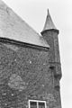 Exterieur VOORGEVEL, HOEKTORENTJE - Well - 20276250 - RCE.jpg 800 × 1,200; 265 KB
-
 Exterieur VOORGEVEL, INGANGSPARTIJ - Well - 20276247 - RCE.jpg 800 × 1,200; 284 KB
-
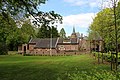
 Exterieur, gracht, park, ruïne - Well - 20363968 - RCE.jpg 783 × 1,200; 270 KB
-
 Exterieur, ingang - Well - 20363971 - RCE.jpg 1,200 × 787; 171 KB
-
 Exterieur, noordgevel - Well - 20363970 - RCE.jpg 1,200 × 789; 230 KB
-
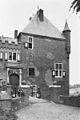
 Exterieur, Voorburcht voor restauratie - Well - 20363963 - RCE.jpg 1,200 × 789; 236 KB
-
 Exterieur, zicht door poort - Well - 20363972 - RCE.jpg 783 × 1,200; 167 KB
-
 Gemetselde pomp bij de toegang naar het kasteel - Well - 20252933 - RCE.jpg 1,200 × 1,197; 426 KB
-
 Gemetselde pomp bij de toegang naar het kasteel - Well - 20252934 - RCE.jpg 1,200 × 1,190; 488 KB
-
 KasteelWell.jpg 566 × 794; 133 KB
-
 Na de restauratie vanuit het zuiden - Well - 20252948 - RCE.jpg 880 × 1,200; 164 KB
-
 Overzicht vanuit het oosten van landschap en dorp - Well - 20252980 - RCE.jpg 1,200 × 804; 214 KB
-
 Overzicht voorgevel met hoektoren - Well - 20359431 - RCE.jpg 1,183 × 1,200; 441 KB
-
 Tekening van kasteel, 1786 - Well - 20407448 - RCE.jpg 1,200 × 891; 317 KB
-
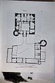 Tekening, plattegrond - Well - 20363962 - RCE.jpg 799 × 1,200; 184 KB
-

-
 Well (14).JPG 3,008 × 2,000; 5.75 MB
-
 Well - Dreef 7 Slot Well - Koetshuis.jpg 5,184 × 3,456; 13.72 MB
-
 Well - Dreef 7 Slot Well - Valbrug.jpg 5,184 × 3,456; 14.7 MB
-
 Well - Slot te Well.jpg 3,000 × 2,000; 5.81 MB
-
 WellGld-Kasteel.jpg 568 × 426; 70 KB
-
 Zicht op het kasteel vanuit het zuidwesten - Well - 20252949 - RCE.jpg 2,773 × 3,741; 2.35 MB
-
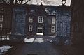
 Zijzicht op ingang met toegangsbrug - Well - 20398048 - RCE.jpg 2,417 × 3,048; 2.33 MB


_Tekening_van_%27t_huis_te_Well_(Gelderland)_2)_Aquarel_van_Dorp_Well_aan_de_Maeze,_1739_(Limburg)_-_Well_-_20407449_-_RCE.jpg)
.JPG)


