Category:Skirlington
Jump to navigation
Jump to search
English: Skirlington is a hamlet in the Holderness area of the East Riding of Yorkshire, England. It is situated approximately 3.5 miles (5.6 km) north of Hornsea on the North Sea coast off the B1242 road.
village in United Kingdom  | |||||
| Upload media | |||||
| Instance of | |||||
|---|---|---|---|---|---|
| Location | East Riding of Yorkshire, Yorkshire and the Humber, England | ||||
 | |||||
Media in category "Skirlington"
The following 14 files are in this category, out of 14 total.
-
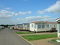 Caravan Site Low Skirlington.jpg 640 × 480; 60 KB
-
 Flooded Pond Skirlington.jpg 4,000 × 3,000; 2.59 MB
-
 Moor Hill Low Skirlington.jpg 640 × 480; 69 KB
-
 Moor Hill, Low Skirlington - geograph.org.uk - 425606.jpg 640 × 458; 139 KB
-
 Skirlington - geograph.org.uk - 74742.jpg 640 × 480; 75 KB
-
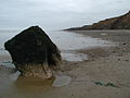
 Skirlington Cliff - geograph.org.uk - 1291468.jpg 640 × 480; 70 KB
-
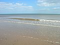 Skirlington Sands - geograph.org.uk - 1291454.jpg 640 × 480; 53 KB
-
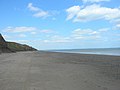 Skirlington Sands - geograph.org.uk - 1291463.jpg 640 × 480; 43 KB
-
 Skirlington Sands - geograph.org.uk - 424138.jpg 640 × 446; 40 KB
-
 Skirlington Sands.jpg 640 × 477; 60 KB
-
 Soft Cliffs Above Skirlington Sands.jpg 640 × 480; 59 KB
-
 Stream Dike, Skirlington - geograph.org.uk - 424122.jpg 480 × 640; 138 KB
-
 Track from Atwick - geograph.org.uk - 256930.jpg 640 × 480; 173 KB
-
 Triangulation Pillar No 10637.jpg 640 × 480; 149 KB


