Category:Sint Nicolaasmolen, Denekamp
Jump to navigation
Jump to search
| Object location | | View all coordinates using: OpenStreetMap |
|---|
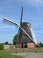
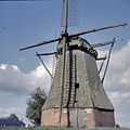
windmill in Denekamp, Netherlands  | |||||
| Upload media | |||||
| Instance of |
| ||||
|---|---|---|---|---|---|
| Location | Denekamp, Dinkelland, Overijssel, Netherlands | ||||
| Street address |
| ||||
| Located on street |
| ||||
| Has use | |||||
| Heritage designation |
| ||||
| Source of energy | |||||
 | |||||
Nederlands: De Sint Nicolaasmolen of Nieuwe Molen is een korenmolen in Denekamp in de Nederlandse provincie Overijssel.
|
This is a category about rijksmonument number 12338
|
| Address |
|
Media in category "Sint Nicolaasmolen, Denekamp"
The following 38 files are in this category, out of 38 total.
-

-
-

-

-

-
 Denekamp - Sint Nicolaasmolen - baard en wiekenkruis.jpg 2,592 × 1,944; 1.67 MB
-
 Denekamp - Sint Nicolaasmolen.jpg 1,944 × 2,592; 2.3 MB
-
 Denekamp, de Sint Nicolaasmolen RM12338 foto2 2016-09-25 10.28.jpg 4,320 × 2,848; 9.03 MB
-
 Deur van gebouw bij achtkante grondzeiler - AMR Molenfoto - 20539778 - RCE.jpg 1,200 × 900; 245 KB
-

-

-

-

-

-

-
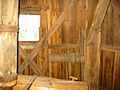
 Interieur achtkante grondzeiler - AMR Molenfoto - 20539779 - RCE.jpg 1,200 × 900; 142 KB
-
 Interieur achtkante grondzeiler - AMR Molenfoto - 20539780 - RCE.jpg 1,200 × 900; 183 KB
-
 Interieur achtkante grondzeiler - AMR Molenfoto - 20539781 - RCE.jpg 1,200 × 900; 185 KB
-
 Interieur achtkante grondzeiler - AMR Molenfoto - 20539782 - RCE.jpg 1,200 × 900; 170 KB
-
 Interieur achtkante grondzeiler - AMR Molenfoto - 20539783 - RCE.jpg 1,200 × 900; 182 KB
-
 Interieur achtkante grondzeiler - AMR Molenfoto - 20539784 - RCE.jpg 1,200 × 900; 188 KB
-
 Interieur achtkante grondzeiler - AMR Molenfoto - 20539785 - RCE.jpg 1,200 × 900; 214 KB
-
 Interieur achtkante grondzeiler - AMR Molenfoto - 20539786 - RCE.jpg 1,200 × 900; 182 KB
-
 Korenmolen in restauratie - Denekamp - 20053618 - RCE.jpg 1,200 × 1,181; 350 KB
-

-
 Molenromp in zeer vervallen staat - Denekamp - 20053625 - RCE.jpg 1,200 × 1,168; 321 KB
-
 Overzicht van de molen - Denekamp - 20420854 - RCE.jpg 834 × 1,200; 182 KB
-
 Overzicht van de molen - Denekamp - 20420855 - RCE.jpg 832 × 1,200; 186 KB
-
 Overzicht van de molen - Denekamp - 20420856 - RCE.jpg 798 × 1,200; 198 KB
-
 Overzicht van de molen - Denekamp - 20420857 - RCE.jpg 836 × 1,200; 170 KB
-
 Overzicht van de molen - Denekamp - 20420858 - RCE.jpg 798 × 1,200; 160 KB
-
 Overzicht van de molen - Denekamp - 20420859 - RCE.jpg 815 × 1,200; 157 KB
-
 Overzicht van de molen - Denekamp - 20420860 - RCE.jpg 847 × 1,200; 220 KB
-
 Overzicht van de molen - Denekamp - 20420861 - RCE.jpg 814 × 1,200; 225 KB
-
 Overzicht, in vervallen staat - Denekamp - 20363736 - RCE.jpg 1,200 × 1,196; 225 KB
-
 Overzicht, in vervallen staat - Denekamp - 20363737 - RCE.jpg 1,196 × 1,200; 287 KB
-
 Overzicht, in vervallen staat - Denekamp - 20363738 - RCE.jpg 1,200 × 1,195; 290 KB
-


