Category:Sint Lambertuslaan 9, Maastricht
Jump to navigation
Jump to search
| Object location | | View all coordinates using: OpenStreetMap |
|---|
building in Maastricht, Netherlands  | |||||
| Upload media | |||||
| Instance of | |||||
|---|---|---|---|---|---|
| Location | Villapark, Maastricht-Zuidwest, Maastricht, Limburg, Netherlands | ||||
| Street address |
| ||||
| Located on street | |||||
| Heritage designation |
| ||||
 | |||||
|
This is a category about rijksmonument number 506660
|
| Address |
|
Media in category "Sint Lambertuslaan 9, Maastricht"
The following 8 files are in this category, out of 8 total.
-
 2016 Maastricht, Villapark 05.JPG 1,728 × 1,152; 1.05 MB
-
 2016 Maastricht, Villapark 05a.JPG 1,282 × 1,037; 812 KB
-
 9-11, voorgevel - Maastricht - 20148941 - RCE.jpg 788 × 1,200; 245 KB
-
 Maastricht - rijksmonument 506660 - Sint Lambertuslaan 9 20100529.jpg 800 × 573; 177 KB
-
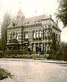 Maastricht, Prins Bisschopsingel, rond-point, Villa Maya, 1910.jpg 386 × 474; 73 KB
-
 Maastricht, Prins Bisschopsingel, rond-point, Villa Maya, 1930.jpg 800 × 502; 206 KB
-
 Maastricht, Sint Lambertuslaan 9 (1).jpg 2,648 × 2,061; 2.52 MB
-
 Maastricht, Sint Lambertuslaan 9 (2).jpg 2,736 × 2,132; 2.09 MB


.jpg)
.jpg)