Category:Sint Ignatiusstraat, Breda
Jump to navigation
Jump to search
| Object location | | View all coordinates using: OpenStreetMap |
|---|
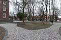
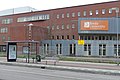
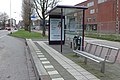
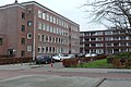
Nederlands: Afbeeldingen van de lange straat de Sint Ignatiusstraat, Breda in Breda in de wijk Brabantpark in de provincie Noord-Brabant in het zuiden van Nederland. Nabij is de Breda University of Applied Sciences gevestigd. Niet ver van het centrum van Breda. Aan beide zijden van de Sint Ignatiusstraat zijn bushaltes. In een deel van de Sint Ignatiusstraat ligt het winkelcentrum Brabantplein met diverse winkels voor de dagelijkse boodschappen.
De Sint Ignatiusstraat is een verlengde van de Nassaustraat en de Wilhelmninasingel en kruist de Beverweg en loopt door tot de rotonde om vervolgens verder te gaan als de Teteringsedijk (bron [1])
street in Breda, the Netherlands | |||||
| Upload media | |||||
| Instance of | |||||
|---|---|---|---|---|---|
| Named after |
| ||||
| Location | Breda, North Brabant, Netherlands | ||||
| Street address |
| ||||
 | |||||
Subcategories
This category has only the following subcategory.
Media in category "Sint Ignatiusstraat, Breda"
The following 13 files are in this category, out of 13 total.
-
 Breda - Sint Ignatiusstraat.jpg 7,008 × 4,636; 24.25 MB
-
 Breda University of Applied Sciences P1330914.jpg 4,000 × 2,672; 5.85 MB
-
 Bushalte P1330948.jpg 4,000 × 2,672; 5.65 MB
-
 Bushalte P1330949.jpg 4,000 × 2,672; 5.8 MB
-
 Bushalte P1330950.jpg 4,000 × 2,672; 5.78 MB
-
 Bushalte P1330951copy.jpg 2,672 × 4,000; 3.3 MB
-
 Bushalte Sint Ignatiusstraat P1330952.jpg 2,672 × 4,000; 4.21 MB
-
 Sint Ignatiusstraat, Breda P1330942.jpg 4,000 × 2,672; 5.94 MB
-
 Sint Ignatiusstraat, Breda P1330944.jpg 4,000 × 2,672; 5.85 MB
-
 Sint Ignatiusstraat, Breda P1330945.jpg 4,000 × 2,672; 5.76 MB
-
 Sint Ignatiusstraat, Breda P1330946.jpg 4,000 × 2,672; 6.15 MB
-
 Sint Ignatiusstraat, Breda P1330947.jpg 4,000 × 2,672; 5.82 MB
-
 Sint Ignatiusstraat, Breda P1330953.jpg 4,000 × 2,672; 5.76 MB


