Category:Sint-Ursulakooster (Boxtel)
Jump to navigation
Jump to search
| Object location | | View all coordinates using: OpenStreetMap |
|---|
 | |||||
| Upload media | |||||
| Instance of | |||||
|---|---|---|---|---|---|
| Location | Boxtel, North Brabant, Netherlands | ||||
| Street address |
| ||||
| Located on street |
| ||||
| Heritage designation |
| ||||
 | |||||
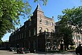
Nederlands: Ursulaklooster Boxtel - anno 1911 - In gebruik als muziekschool
|
This is a category about rijksmonument number 516638
|
| Address |
|
Media in category "Sint-Ursulakooster (Boxtel)"
The following 9 files are in this category, out of 9 total.
-
 516638 Sint Ursulaklooster.jpg 2,189 × 3,000; 4.26 MB
-
 Boxtel - St. Ursula klooster (1).jpg 800 × 534; 365 KB
-
 Boxtel - St. Ursula klooster - Beeld St. Ursula.jpg 533 × 800; 407 KB
-
 Boxtel - St. Ursula klooster.jpg 800 × 534; 360 KB
-
 Boxtel 516638 - St. Ursula klooster - Kloosternaam.jpg 800 × 534; 369 KB
-
 Sint Ursulaklooster, Baroniestraat 22 Boxtel - detail (2).JPG 4,000 × 3,000; 3.1 MB
-
 Sint Ursulaklooster, Baroniestraat 22 Boxtel - detail (3).JPG 4,000 × 3,000; 3.81 MB
-
 Sint Ursulaklooster, Baroniestraat 22 Boxtel - detail.JPG 3,000 × 4,000; 3.31 MB
-
 Sint Ursulaklooster, Baroniestraat 22 Boxtel.JPG 3,000 × 4,000; 3.9 MB

.jpg)


.JPG)
.JPG)

