Category:Sint-Pieterkerk (Grou)
Jump to navigation
Jump to search
| Object location | | View all coordinates using: OpenStreetMap |
|---|
church building in Boarnsterhim, Netherlands  | |||||
| Upload media | |||||
| Instance of | |||||
|---|---|---|---|---|---|
| Dedicated to | |||||
| Location | Grou, Friesland, Netherlands | ||||
| Street address |
| ||||
| Located on street | |||||
| Heritage designation |
| ||||
| Inception |
| ||||
| Significant event |
| ||||
| official website | |||||
 | |||||
Nederlands: Sint-Pieterkerk, Grou (Grouw), gem. Leeuwarden, Friesland
|
This is a category about rijksmonument number 22894
|
| Address |
|
Subcategories
This category has the following 2 subcategories, out of 2 total.
I
T
Media in category "Sint-Pieterkerk (Grou)"
The following 56 files are in this category, out of 56 total.
-
 2023 Grou, Sint-Pitertsjerke.jpg 2,252 × 2,254; 2.05 MB
-
 Aantal voorgevels en kerktoren met zadeldak - Grouw - 20407141 - RCE.jpg 1,184 × 1,200; 265 KB
-
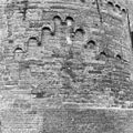
 Buitenzijde van het koor met klimmend boogfries - Grouw - 20409251 - RCE.jpg 886 × 1,200; 253 KB
-
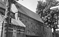
 De kerk van Grouw met op de voorgrond een zeilmakerij, Bestanddeelnr 191-0663.jpg 2,580 × 2,611; 984 KB
-
 Detail kerktoren - Grouw - 20404430 - RCE.jpg 984 × 1,200; 380 KB
-
 Detail noordoost zijde van het koor, klimmend rondboogfries - Grouw - 20398646 - RCE.jpg 1,200 × 1,198; 556 KB
-
 Detail noordoost zijde van het koor, rondboogfries - Grouw - 20398648 - RCE.jpg 1,200 × 1,198; 483 KB
-

-

-

-
 Detail tufsteen in het koor, klimmend rondboogfries - Grouw - 20398647 - RCE.jpg 1,200 × 1,198; 570 KB
-
 Detail zuidgevel van het schip, zonnewijzer, muurankers - Grouw - 20398649 - RCE.jpg 1,190 × 1,200; 498 KB
-
 Drachtsterweg met Parkeerplaats en de Kerk. Grouw.JPG 4,608 × 3,456; 5.64 MB
-
 Exterieur TEKENING VAN DE NOORDGEVEL - Grouw - 20262725 - RCE.jpg 1,200 × 952; 92 KB
-
-
 Grou, Sint-Pitertsjerke (fanút it súdeasten).jpg 5,438 × 3,769; 10.35 MB
-
 Grou, Sint-Pitertsjerke.jpg 5,309 × 3,682; 15.21 MB
-
 Grou1.jpg 1,836 × 3,264; 2.45 MB
-
 Grouw - Kerk lichter.jpg 2,472 × 3,296; 5.2 MB
-
 Grouw - Kerk.jpg 2,472 × 3,296; 960 KB
-
 Kerktoren met dorpsgezicht op de voorgrond - Grouw - 20398199 - RCE.jpg 957 × 1,200; 246 KB
-
 Kerktoren met zadeldak - Grouw - 20404428 - RCE.jpg 960 × 1,200; 260 KB
-
 Kerktoren met zadeldak - Grouw - 20404429 - RCE.jpg 965 × 1,200; 272 KB
-
 Noordgevel - Grouw - 20383483 - RCE.jpg 785 × 1,200; 280 KB
-
 Noordgevel van het koor - Grouw - 20398639 - RCE.jpg 954 × 1,200; 293 KB
-
 Noordgevel van het schip met dakruiter - Grouw - 20398642 - RCE.jpg 955 × 1,200; 330 KB
-
 Noordgevel van het schip, westtoren met zadeldak - Grouw - 20398641 - RCE.jpg 946 × 1,200; 331 KB
-

-

-

-

-
 Overzicht kerk, gevel met rondboogfries - Grouw - 20403553 - RCE.jpg 771 × 1,200; 216 KB
-

-
 Overzicht kerktoren - Grouw - 20406740 - RCE.jpg 968 × 1,200; 304 KB
-

-

-

-

-

-

-

-
 Schip gezien vanuit het noorden - Grouw - 20326562 - RCE.jpg 1,200 × 892; 271 KB
-
 Sint Pieter kerk Grou.jpg 1,536 × 2,048; 578 KB
-
 Sint Pieterkerk Grou toren.jpg 1,368 × 1,824; 783 KB
-
 Sint Pieterkerk Grou.jpg 1,824 × 1,368; 947 KB
-
 Sint Pieterkerk2 Grou.jpg 1,824 × 1,368; 843 KB
-

-

-
 Toreningang met gevelsteen - Grouw - 20398200 - RCE.jpg 1,200 × 960; 423 KB
-
 Toreningang met gevelsteen - Grouw - 20398201 - RCE.jpg 958 × 1,200; 439 KB
-
 Zuidgevel met toren - Grouw - 20326430 - RCE.jpg 1,200 × 894; 301 KB
-
 Zuidgevel van kerk, boom op de voorgrond - Grouw - 20398635 - RCE.jpg 948 × 1,200; 388 KB
-
 Zuidgevel van kerk, boom op de voorgrond - Grouw - 20398636 - RCE.jpg 939 × 1,200; 398 KB
-

-
 Zuidwest zijde van de toren - Grouw - 20406739 - RCE.jpg 968 × 1,200; 261 KB
-


.jpg)


