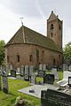
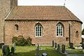
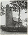
Category:Sint-Petruskerk (Jistrum)
Jump to navigation
Jump to search
| Object location | | View all coordinates using: OpenStreetMap |
|---|
church  | |||||
| Upload media | |||||
| Instance of | |||||
|---|---|---|---|---|---|
| Dedicated to | |||||
| Location | Jistrum, Tytsjerksteradiel, Friesland, Netherlands | ||||
| Street address |
| ||||
| Located on street |
| ||||
| Heritage designation |
| ||||
| Inception |
| ||||
| official website | |||||
 | |||||
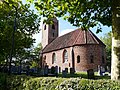
Nederlands: Sint-Petruskerk (Hervormde kerk), Jistrum (Eestrum) - anno 13e eeuw
|
This is a category about rijksmonument number 35645
|
| Address |
|
Media in category "Sint-Petruskerk (Jistrum)"
The following 67 files are in this category, out of 67 total.
-
 20210824 Sint Petruskerk1 Jistrum.jpg 4,712 × 3,141; 3.72 MB
-
 20210824 Sint Petruskerk2 Jistrum.jpg 2,983 × 4,474; 3.56 MB
-
 20210824 Sint Petruskerk3 Jistrum.jpg 3,456 × 5,184; 3.4 MB
-
 20210824 Toren Sint Petruskerk2 Jistrum.jpg 3,456 × 5,184; 3.02 MB
-
 20210824 Windvaan1 Sint Petruskerk2 Jistrum.jpg 3,456 × 5,184; 2.43 MB
-
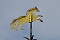 20210824 Windvaan2 Sint Petruskerk2 Jistrum.jpg 5,184 × 3,456; 2.02 MB
-
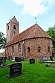
 Church Jistrum.jpg 3,264 × 2,448; 3.56 MB
-

-
 Detail van voegwerk in slechte staat - Jistrum - 20387659 - RCE.jpg 1,200 × 800; 382 KB
-
 Eestrum zuidoost 20387656 - RCE.jpg 905 × 801; 601 KB
-
 Exterieur - Eestrum - 20067826 - RCE.jpg 937 × 1,200; 170 KB
-
 Exterieur - Eestrum - 20067829 - RCE.jpg 1,200 × 942; 279 KB
-
 Exterieur noordgevel - Eestrum - 20067839 - RCE.jpg 1,200 × 943; 278 KB
-
 Exterieur vanuit het oosten - Eestrum - 20067828 - RCE.jpg 790 × 1,200; 185 KB
-
 Exterieur vanuit het zuid-oosten - Eestrum - 20067827 - RCE.jpg 888 × 1,200; 258 KB
-

-

-

-

-

-

-

-
 Exterieur zuid-oost gevel - Eestrum - 20067837 - RCE.jpg 954 × 1,200; 249 KB
-
 Exterieur zuidgevel - Eestrum - 20067838 - RCE.jpg 1,200 × 955; 245 KB
-
 Hagioscoop - Eestrum - 20067830 - RCE.jpg 963 × 1,200; 355 KB
-
 Interieur - Eestrum - 20067833 - RCE.jpg 953 × 1,200; 203 KB
-

-
 Interieur gezien naar het oosten - Eestrum - 20323589 - RCE.jpg 1,200 × 843; 141 KB
-
 Interieur met preekstoel - Eestrum - 20067834 - RCE.jpg 856 × 1,200; 154 KB
-
 Interieur naar het oosten - Eestrum - 20067840 - RCE.jpg 1,200 × 960; 188 KB
-
 Interieur naar het westen - Eestrum - 20067841 - RCE.jpg 1,200 × 950; 188 KB
-
-

-

-
 Interieur, overzicht richting het orgel - Jistrum - 20387664 - RCE.jpg 1,200 × 800; 163 KB
-
-

-
 Interieur, overzicht van het orgel - Jistrum - 20387669 - RCE.jpg 800 × 1,200; 117 KB
-
 Inwendig naar het westen en naar het oosten - Eestrum - 20067831 - RCE.jpg 838 × 1,200; 134 KB
-
 Inwendig naar het westen en naar het oosten - Eestrum - 20067832 - RCE.jpg 827 × 1,200; 129 KB
-
 Jistrum hagioscoop.JPG 2,448 × 3,264; 3.61 MB
-

-
 Overzicht noordoostgevel met kerktoren en kerkhof - Eestrum - 20345877 - RCE.jpg 1,200 × 950; 288 KB
-
 Overzicht noordoostgevel met kerktoren en kerkhof - Eestrum - 20345878 - RCE.jpg 1,200 × 956; 246 KB
-
-
-

-
-

-

-
 Overzicht van een koepelgewelf - Eestrum - 20379593 - RCE.jpg 925 × 1,200; 149 KB
-
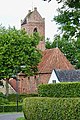
 Overzicht vanuit het zuiden met de omgeving - Jistrum - 20387662 - RCE.jpg 1,200 × 800; 257 KB
-
 Overzicht vanuit het zuidwesten - Jistrum - 20387661 - RCE.jpg 807 × 1,200; 361 KB
-
 Overzicht zuidzijde - Eestrum - 20323493 - RCE.jpg 1,200 × 769; 146 KB
-
 Protestantse kerk Jistrum.jpg 1,823 × 1,369; 2.41 MB
-
 Roots - The old Church.jpg 2,000 × 1,500; 828 KB
-
 Sint Petruskerk Jistrum (detail).jpg 984 × 1,000; 167 KB
-
 Sint Petruskerk Jistrum.jpg 1,824 × 1,368; 784 KB
-
 Sint-Petruskerk, Eestrum 1.jpg 2,309 × 1,732; 1.78 MB
-
 Sint-Petruskerk, Eestrum 2.jpg 2,309 × 1,732; 1.68 MB
-
 Sint-Petruskerk, Eestrum 3.jpg 2,309 × 1,732; 2.75 MB
-
 SintPetruskerk Jistrum.jpg 3,072 × 2,304; 2.24 MB
-
 Toren westzijde - Eestrum - 20067836 - RCE.jpg 954 × 1,200; 203 KB
-
 Zicht vanuit het noordwesten - Eestrum - 20323511 - RCE.jpg 653 × 1,200; 124 KB
-
 Zicht vanuit het zuidoosten - Eestrum - 20323512 - RCE.jpg 750 × 1,200; 155 KB
-
 Zicht vanuit het zuidoosten - Eestrum - 20324878 - RCE.jpg 882 × 1,200; 177 KB
-
 Zicht vanuit het zuidwesten - Eestrum - 20326443 - RCE.jpg 955 × 1,200; 350 KB


.jpg)


