Category:Sint-Pauluskerk (Sint-Pauwels)
Jump to navigation
Jump to search
| Object location | | View all coordinates using: OpenStreetMap |
|---|
|
This is a category about Beschermd erfgoed number 11086
|
|
This is a category about onroerend erfgoed number 14881
|
church in Sint-Pauwels, Belgium  | |||||
| Upload media | |||||
| Instance of | |||||
|---|---|---|---|---|---|
| Dedicated to | |||||
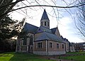
| Location | Sint-Pauwels, Sint-Gillis-Waas, Arrondissement of Sint-Niklaas, East Flanders, Flemish Region, Belgium | ||||
| Diocese | |||||
 | |||||
Media in category "Sint-Pauluskerk (Sint-Pauwels)"
The following 4 files are in this category, out of 4 total.
-
 Sint-Pauwels kerk.jpg 1,600 × 1,143; 339 KB
-
 Sint-Pauwels no1.jpg 847 × 1,280; 277 KB
-
 Sint-Pauwels no2.jpg 1,280 × 847; 275 KB
-
 Sint-Pauwels no3.jpg 1,280 × 847; 278 KB


Categories:
- Onroerend erfgoed in Sint-Pauwels
- Churches in Belgium by name
- Churches in Sint-Gillis-Waas
- Saint Paul churches in Belgium
- 13th-century churches in East Flanders
- Gothic churches in East Flanders
- Stone churches in Belgium
- Brick Gothic churches in East Flanders
- Gothic Revival brick churches in East Flanders
- Pseudobasilicas in East Flanders
- Hall churches in East Flanders