Category:Sint-Odradakerk (Millegem, Mol)
Jump to navigation
Jump to search
| Object location | | View all coordinates using: OpenStreetMap |
|---|
|
This is a category about onroerend erfgoed number 52850
|
church in Millegem (Mol), Belgium  | |||||
| Upload media | |||||
| Instance of | |||||
|---|---|---|---|---|---|
| Dedicated to |
| ||||
| Location | Millegem, Mol, Mol, Arrondissement of Turnhout, Province of Antwerp, Flemish Region, Belgium | ||||
| Diocese | |||||
| Heritage designation | |||||
 | |||||
Media in category "Sint-Odradakerk (Millegem, Mol)"
The following 8 files are in this category, out of 8 total.
-
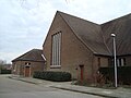
 Achterkant Sint-Odradakerk.jpg 3,072 × 2,304; 2.11 MB
-
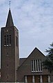 Kerkmillegem.jpeg 360 × 563; 13 KB
-
 Mol - Sint-Odradakerk.jpg 2,048 × 1,536; 997 KB
-
 Parochiekerk Sint-Odrada Mol-Millegem.jpg 4,752 × 3,168; 3.8 MB
-
 Sint-Odradekerk vooraanzicht.jpg 3,072 × 2,304; 2.69 MB
-
 Voorkant Sint-Odradakerk.jpg 3,072 × 2,304; 2.42 MB
-
 Zijaanzicht Sint-Odradakerk (achterzijde).jpg 3,072 × 2,304; 2.66 MB
-
 Zijaanzicht Sint-Odradakerk (voorzijde).jpg 2,304 × 3,072; 2.47 MB


.jpg)
.jpg)