Category:Sint-Martinuskerk (Welden)
Jump to navigation
Jump to search
| Object location | | View all coordinates using: OpenStreetMap |
|---|
|
This is a category about onroerend erfgoed number 27802
|
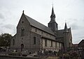
church building in Welden (Oudenaarde), Belgium   | |||||
| Upload media | |||||
| Instance of | |||||
|---|---|---|---|---|---|
| Named after | |||||
| Dedicated to | |||||
| Location | Welden, Oudenaarde, Arrondissement of Oudenaarde, East Flanders, Flemish Region, Belgium | ||||
| Street address |
| ||||
| Architectural style | |||||
| Diocese | |||||
| Architect |
| ||||
| Heritage designation | |||||
| Inception |
| ||||
| Religion or worldview | |||||
 | |||||
Subcategories
This category has the following 2 subcategories, out of 2 total.
G
I
Media in category "Sint-Martinuskerk (Welden)"
The following 19 files are in this category, out of 19 total.
-
 PM 117617 B Welden.jpg 600 × 399; 265 KB
-
 PM 117619 B Welden.jpg 600 × 351; 162 KB
-
 PM 117622 B Welden.jpg 600 × 422; 198 KB
-
 PM 117625 B Welden.jpg 600 × 400; 383 KB
-
 PM 117634 B Welden.jpg 600 × 283; 149 KB
-
 PM 117635 B Welden.jpg 400 × 600; 191 KB
-
 PM 117646 B Welden.jpg 600 × 442; 226 KB
-
 PM 117647 B Welden.jpg 453 × 600; 253 KB
-
 PM 117648 B Welden.jpg 600 × 429; 200 KB
-
 PM 133903 E Welden.jpg 600 × 400; 209 KB
-
 PM 133904 E Welden.jpg 400 × 600; 214 KB
-
 PM 133905 E Welden.jpg 385 × 600; 299 KB
-
 PM 133906 E Welden.jpg 400 × 600; 287 KB
-
 PM 133908 E Welden.jpg 388 × 600; 151 KB
-
 PM 133910 E Welden.jpg 332 × 600; 103 KB
-
 Sint-Martinuskerk - Welden - 2016.jpg 2,560 × 1,920; 1.18 MB
-
 Sint-Martinuskerk en Grafkapel - Welden - 2016.jpg 2,560 × 1,920; 1.24 MB
-
 Sint-Martinuskerk Welden.jpg 1,048 × 1,499; 221 KB
-
 Welden, de Sint Martinuskerk foto1 2013-05-07 14.12.jpg 4,259 × 3,226; 10.13 MB


Categories:
- Welden (Oudenaarde)
- Churches in Belgium by name
- Churches in Oudenaarde
- Onroerend erfgoed in Oudenaarde
- Saint Martin churches in Belgium
- 12th-century churches in East Flanders
- 19th-century churches in East Flanders
- Stone churches in Belgium
- Romanesque churches in East Flanders
- Brick Gothic churches in East Flanders
- Romanesque Revival churches in East Flanders
- Architectural basilicas in East Flanders