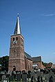
Category:Sint-Martinuskerk (Hallum)
Jump to navigation
Jump to search
| Object location | | View all coordinates using: OpenStreetMap |
|---|
church building in Hallum  | |||||
| Upload media | |||||
| Instance of | |||||
|---|---|---|---|---|---|
| Dedicated to | |||||
| Location | Hallum, Noardeast-Fryslân, Friesland, Netherlands | ||||
| Street address |
| ||||
| Located on street |
| ||||
| Heritage designation |
| ||||
| Inception |
| ||||
| Significant event |
| ||||
| official website | |||||
 | |||||
|
This is a category about rijksmonument number 15618
|
| Address |
|
Media in category "Sint-Martinuskerk (Hallum)"
The following 86 files are in this category, out of 86 total.
-
 20200603 zicht op Hallum met Sint Martinuskerk.jpg 5,011 × 3,340; 2.35 MB
-
 20220808 PKN-tsjerke Sint-Martinus, Hallum.jpg 2,239 × 2,546; 1.86 MB
-
 Avondmaalsbeker 1718 - Hallum - 20099980 - RCE.jpg 941 × 1,200; 128 KB
-
 Avondmaalsbeker 1816 - Hallum - 20099979 - RCE.jpg 936 × 1,200; 112 KB
-
 Avondmaalstafel - Hallum - 20099970 - RCE.jpg 1,200 × 946; 256 KB
-
 Detail speeltafel van het oreel - Hallum - 20099969 - RCE.jpg 1,197 × 1,200; 273 KB
-
 Exterieur OVERZICHT ZUIDGEVEL - Hallum - 20262632 - RCE.jpg 793 × 1,200; 181 KB
-

-

-

-

-

-

-

-
 Gevel koor - Hallum - 20099960 - RCE.jpg 956 × 1,200; 289 KB
-

-

-

-
 Hallum - Sint Martinuskerk-001.JPG 1,067 × 1,600; 441 KB
-
 Hallum - Sint Martinuskerk-004.JPG 1,067 × 1,600; 534 KB
-
 Hallum - Sint Martinuskerk-011.JPG 1,067 × 1,600; 683 KB
-
 Hallum - St. Martinus. Martinus.JPG 2,592 × 3,888; 2.41 MB
-
 Hallum - St. Martinus.JPG 3,888 × 2,592; 3.31 MB
-
 Hallum, Grutte- of Sint Martenstsjerke, gevelstien yn toer.jpg 5,406 × 3,862; 9.9 MB
-
 Hallum, Grutte- of Sint-Martenstsjerke.jpg 5,471 × 3,908; 7.59 MB
-
 Herenbank en preekstoel - Hallum - 20099971 - RCE.jpg 1,200 × 953; 183 KB
-
 Interieur met orgel - Hallum - 20099965 - RCE.jpg 949 × 1,200; 200 KB
-
 Interieur naar het oosten - Hallum - 20099948 - RCE.jpg 1,003 × 1,200; 161 KB
-
 Interieur naar het westen - Hallum - 20099949 - RCE.jpg 980 × 1,200; 190 KB
-
 Interieur naar het westen - Hallum - 20099961 - RCE.jpg 949 × 1,200; 197 KB
-
 Interieur naar het westen en preekstoel - Hallum - 20099962 - RCE.jpg 955 × 1,200; 220 KB
-
 Interieur, aanzicht orgel, orgelnummer 591 - Hallum - 20358268 - RCE.jpg 805 × 1,200; 167 KB
-
 INTERIEUR, PREEKSTOEL - Hallum - 20262633 - RCE.jpg 771 × 1,200; 111 KB
-
 Leibedekking (kleur) - Hallum - 20099990 - RCE.jpg 1,200 × 783; 174 KB
-
 Leibedekking (kleur) - Hallum - 20099991 - RCE.jpg 783 × 1,200; 205 KB
-
 Leibedekking (kleur) - Hallum - 20099992 - RCE.jpg 783 × 1,200; 206 KB
-
 Leibedekking (kleur) - Hallum - 20099993 - RCE.jpg 1,200 × 795; 207 KB
-
 Leibedekking (kleur) - Hallum - 20099994 - RCE.jpg 783 × 1,200; 213 KB
-
 Leibedekking (kleur) - Hallum - 20099995 - RCE.jpg 1,200 × 782; 190 KB
-
 Leibedekking (kleur) - Hallum - 20099996 - RCE.jpg 1,200 × 783; 188 KB
-
 Leibedekking (kleur) - Hallum - 20099997 - RCE.jpg 783 × 1,200; 201 KB
-
 Leibedekking (kleur) - Hallum - 20099998 - RCE.jpg 783 × 1,200; 218 KB
-
 Leibedekking (kleur) - Hallum - 20099999 - RCE.jpg 1,200 × 783; 194 KB
-
 Leibedekking (kleur) - Hallum - 20100000 - RCE.jpg 783 × 1,200; 189 KB
-
 Leibedekking (kleur) - Hallum - 20100001 - RCE.jpg 783 × 1,200; 191 KB
-
 Leibedekking (kleur) - Hallum - 20100002 - RCE.jpg 1,200 × 783; 159 KB
-
 Leibedekking (kleur) - Hallum - 20100003 - RCE.jpg 1,200 × 783; 213 KB
-
 Leibedekking (kleur) - Hallum - 20100004 - RCE.jpg 1,200 × 783; 162 KB
-
 Leibedekking (kleur) - Hallum - 20100005 - RCE.jpg 1,200 × 783; 170 KB
-
 Leibedekking (kleur) - Hallum - 20100006 - RCE.jpg 783 × 1,200; 134 KB
-
 Leibedekking (kleur) - Hallum - 20100007 - RCE.jpg 1,200 × 783; 204 KB
-
 Leibedekking (kleur) - Hallum - 20100008 - RCE.jpg 1,200 × 783; 218 KB
-
 Leibedekking (kleur) - Hallum - 20100009 - RCE.jpg 1,200 × 783; 218 KB
-
 Noord kapel noordgevel - Hallum - 20099987 - RCE.jpg 1,200 × 798; 335 KB
-
 Noord kapel noordgevel - Hallum - 20099988 - RCE.jpg 1,200 × 796; 341 KB
-
 Noord kapel noordgevel - Hallum - 20099989 - RCE.jpg 1,200 × 802; 331 KB
-
 Noord-oost gevel - Hallum - 20099955 - RCE.jpg 958 × 1,200; 302 KB
-
 Noordelijke aanbouw kerk - Hallum - 20099957 - RCE.jpg 958 × 1,200; 332 KB
-
 Noordelijke aanbouw naar het zuid-westen - Hallum - 20099959 - RCE.jpg 960 × 1,200; 324 KB
-
 Noordgevel - Hallum - 20099956 - RCE.jpg 1,200 × 959; 283 KB
-
 Noordgevel - Hallum - 20099958 - RCE.jpg 1,200 × 960; 364 KB
-
 Orgel en avondmaalstafel - Hallum - 20099966 - RCE.jpg 960 × 1,200; 212 KB
-
 Overzicht noordoostgevel met kerktoren en kerkhof - Hallum - 20345472 - RCE.jpg 941 × 1,200; 274 KB
-
 Overzicht zuidgevel - Hallum - 20099950 - RCE.jpg 1,200 × 945; 233 KB
-
 Portaal zuidelijke ingang - Hallum - 20099972 - RCE.jpg 961 × 1,200; 174 KB
-
 Preekstoel - Hallum - 20099963 - RCE.jpg 962 × 1,200; 180 KB
-
 Preekstoel en doophek - Hallum - 20099964 - RCE.jpg 971 × 1,200; 200 KB
-
 Rouwbord - Hallum - 20099978 - RCE.jpg 956 × 1,200; 177 KB
-
 Rouwbord links van het orgel - Hallum - 20099973 - RCE.jpg 1,192 × 1,200; 378 KB
-
 Rouwbord rechts van het orgel - Hallum - 20099974 - RCE.jpg 1,192 × 1,200; 334 KB
-
 Rouwbord rechts van het orgel - Hallum - 20099975 - RCE.jpg 1,197 × 1,200; 269 KB
-
 Rugwerk van het orgel en avondmaalstafel - Hallum - 20099967 - RCE.jpg 959 × 1,200; 231 KB
-
 Schotels 1787 - Hallum - 20099977 - RCE.jpg 1,200 × 951; 144 KB
-
 Sleutelstuk zuid kapel - Hallum - 20099985 - RCE.jpg 793 × 1,200; 176 KB
-
 Speeltafel van het orgel - Hallum - 20099968 - RCE.jpg 1,192 × 1,200; 294 KB
-
 St.Martinus kerk in Hallum.jpg 1,067 × 1,600; 209 KB
-
 Tekstbord - Hallum - 20099976 - RCE.jpg 958 × 1,200; 165 KB
-
 West kapel opgraving fundering abside - Hallum - 20099984 - RCE.jpg 1,200 × 785; 318 KB
-
 Wijnkan met zilveren deksel - Hallum - 20099982 - RCE.jpg 956 × 1,200; 139 KB
-
 Wijnkan met zilveren deksel 1653 - Hallum - 20099983 - RCE.jpg 964 × 1,200; 122 KB
-
 Wijnkan zilver deksel - Hallum - 20099981 - RCE.jpg 952 × 1,200; 151 KB
-
 Zuid kapel paringsmerken bekapping - Hallum - 20099986 - RCE.jpg 801 × 1,200; 196 KB
-
 Zuid-oost gevel - Hallum - 20099952 - RCE.jpg 961 × 1,200; 221 KB
-
 Zuid-west gevel - Hallum - 20099951 - RCE.jpg 965 × 1,200; 175 KB
-
 Zuidelijke aanbouw - Hallum - 20099953 - RCE.jpg 1,200 × 949; 274 KB
-
 Zuidelijke aanbouw - Hallum - 20099954 - RCE.jpg 954 × 1,200; 310 KB


,_RP-P-1905-5404.jpg)
_en_van_zijne_vrouw_Tjets_van_IJdsma_(titel_op_object),_RP-P-1905-5450.jpg)
,_RP-P-1905-5405.jpg)


_-_Hallum_-_20099990_-_RCE.jpg)
_-_Hallum_-_20099991_-_RCE.jpg)
_-_Hallum_-_20099992_-_RCE.jpg)
_-_Hallum_-_20099993_-_RCE.jpg)
_-_Hallum_-_20099994_-_RCE.jpg)
_-_Hallum_-_20099995_-_RCE.jpg)
_-_Hallum_-_20099996_-_RCE.jpg)
_-_Hallum_-_20099997_-_RCE.jpg)
_-_Hallum_-_20099998_-_RCE.jpg)
_-_Hallum_-_20099999_-_RCE.jpg)
_-_Hallum_-_20100000_-_RCE.jpg)
_-_Hallum_-_20100001_-_RCE.jpg)
_-_Hallum_-_20100002_-_RCE.jpg)
_-_Hallum_-_20100003_-_RCE.jpg)
_-_Hallum_-_20100004_-_RCE.jpg)
_-_Hallum_-_20100005_-_RCE.jpg)
_-_Hallum_-_20100006_-_RCE.jpg)
_-_Hallum_-_20100007_-_RCE.jpg)
_-_Hallum_-_20100008_-_RCE.jpg)
_-_Hallum_-_20100009_-_RCE.jpg)


