Category:Singel 7, Sint Anna ter Muiden
Jump to navigation
Jump to search
| Object location | | View all coordinates using: OpenStreetMap |
|---|
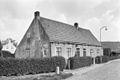
house in Sluis, Netherlands  | |||||
| Upload media | |||||
| Instance of | |||||
|---|---|---|---|---|---|
| Location | Sluis, Zeeland, Netherlands | ||||
| Street address |
| ||||
| Located on street |
| ||||
| Heritage designation |
| ||||
 | |||||
|
This is a category about rijksmonument number 33970
|
| Address |
|
Media in category "Singel 7, Sint Anna ter Muiden"
The following 2 files are in this category, out of 2 total.
-
 50, aanzicht - Sint Anna ter Muiden - 20023016 - RCE.jpg 3,308 × 2,208; 2.27 MB
-
 SintAnne Singel7.jpg 3,456 × 2,304; 3.34 MB
