Category:Signs in Lower Saxony
Jump to navigation
Jump to search
Federal states of Germany:
Subcategories
This category has the following 81 subcategories, out of 81 total.
- Banners in Lower Saxony (4 F)
- Twin town signs in Lower Saxony (10 F)
- Signs of Boxenstopp-Route (3 F)
- Signs of Deutsche Fehnroute (3 F)
!
A
B
- Signs in Bad Bodenteich (12 F)
- Signs in Bassum (6 F)
- Signs in Bienenbüttel (9 F)
C
D
- Signs in Delmenhorst (1 F)
E
F
G
H
- Signs in Hemmoor (5 F)
I
L
M
- Signs in Mittegroßefehn (20 F)
- Signs in Munster (Örtze) (9 F)
N
- Signs in Nordhorn (5 F)
O
P
R
S
- Signs in Schneverdingen (41 F)
- Signs in Dransfeld (1 F)
- Signs in Syke (2 F)
U
- Signs in Uelzen (18 F)
V
W
- Signs in Walsrode (2 F)
- Signs in Wieren (8 F)
- Signs in Wilhelmshaven (1 F)
Media in category "Signs in Lower Saxony"
The following 155 files are in this category, out of 155 total.
-
 2008 02 Hohe Sieben Duemmer 0175.jpg 1,463 × 2,200; 529 KB
-
 2010 Waldbrandwarnschild 01.jpg 1,224 × 1,730; 814 KB
-

-

-
 2016-09-12 ehemaliges Brauhaus in Ruthe, Informationstafel am Gebäude.jpg 3,946 × 2,934; 9.8 MB
-

-

-
 700jährige Eiche im Amt Neuhaus 04.jpg 4,320 × 2,880; 5.07 MB
-
 Aller (Fluss) Fähre Oldau 2008 by-RaBoe 12.jpg 1,000 × 750; 747 KB
-
 Allerwarnschild in Westen (Dörverden) IMG 9244.jpg 3,000 × 2,000; 807 KB
-
 Am roten Steine (1).JPG 3,714 × 2,486; 2.84 MB
-
 Am roten Steine (2).JPG 2,680 × 1,794; 1.48 MB
-
 Aquamarin Casino Seevetal.jpg 3,072 × 2,304; 2.82 MB
-
 Ausschilderung der Parkplätze.jpg 1,416 × 1,064; 193 KB
-
 Bahnhof Leese-Stolzenau, alter Wegweiser.JPG 2,112 × 2,816; 3.11 MB
-
 Bawinkel.jpg 1,299 × 1,536; 969 KB
-
 Bursfelde Weserradweg.JPG 1,024 × 768; 393 KB
-
 Bülkau-2012 by-RaBoe 19.jpg 1,111 × 738; 459 KB
-
 Cuxhaven 2014-6 by-RaBoe 085.jpg 2,555 × 1,697; 2.6 MB
-
 Deutsche Faehrstrasse.jpg 2,448 × 3,264; 3.82 MB
-
 DuellplatzSauparkSpringe.jpg 1,305 × 1,825; 494 KB
-
 Emmerstedt Ortsschild.JPG 3,264 × 2,448; 2.78 MB
-
 Erholungsgebiet Grosser Deister Karte.jpg 852 × 1,136; 585 KB
-
 Erholungsgebiet kleiner deister karte.jpg 1,136 × 852; 513 KB
-
 Evangelischer Jugendhof Sachsenhain - Schild.jpg 2,816 × 2,112; 2.96 MB
-
 Ewiges Meer matthiassuessen-7501.jpg 2,997 × 2,548; 1.75 MB
-
 Fertig.jpg 5,496 × 3,670; 8.32 MB
-
 Huegelgrab Ganderkesee 5.JPG 2,272 × 1,704; 848 KB
-
 Huegelgrab Ganderkesee 6.JPG 2,272 × 1,704; 850 KB
-
 Huegelgrab Ganderkesee 7.JPG 2,272 × 1,704; 839 KB
-
 Huegelgrab Ganderkesee 9.JPG 2,272 × 1,704; 850 KB
-
 German Roadsign 310 in wrong usage.jpg 1,200 × 1,200; 641 KB
-
 Gimte Schild.jpg 391 × 493; 180 KB
-
 Goldhort Gessel Fundbereich Feld.jpg 1,899 × 950; 2.53 MB
-
 Grenzschild Landkreis Harburg.jpg 1,224 × 1,903; 355 KB
-
 Grüner See Schild Falk Oberdorf.jpg 1,743 × 1,533; 465 KB
-
 Wegweiser Partnerstaedte von Hameln.jpg 2,249 × 1,500; 1.35 MB
-
 Himmelsrutsche Schild.jpg 4,896 × 3,672; 8.52 MB
-
 Hohegeiss byskilt.JPG 2,592 × 1,944; 1.75 MB
-
 Höfer Info am Schacht.JPG 2,395 × 3,224; 8.07 MB
-
 Karte am Pilsumer Leuchtturm 20200911 DSC3658.jpg 6,000 × 4,000; 10.63 MB
-
 KH Salzhausen Tafel.jpg 1,483 × 1,047; 972 KB
-
 Kloster Wienhausen Fabianeiche Tafel 8921.jpg 2,688 × 2,944; 6.72 MB
-
 König Georgs Eiche-Namensschild.JPG 1,800 × 1,800; 1.47 MB
-
 Landschaftsschutzgebiet Bergholz - Östllicher Rand (1).JPG 5,098 × 3,389; 4.54 MB
-

-

-
-

-

-
 Landschaftsschutzgebiet Hainberg - Wohldenberg - Hinweisschild.jpg 3,348 × 5,035; 4.26 MB
-
 Landschaftsschutzgebiet Nördlicher Osterwald und Umgebung - Schild am Großen Rotehengst.JPG 2,667 × 4,000; 2.83 MB
-

-

-

-
 Landschaftsschutzgebiet Solling - Alte Hauung bei Espol - Hinweisschilder (1).jpg 3,707 × 5,575; 5.22 MB
-
 Landschaftsschutzgebiet Solling - Alte Hauung bei Espol - Hinweisschilder (2).jpg 2,667 × 4,000; 2.88 MB
-
 Landschaftsschutzgebiet Solling - Am Bussberg bei Ertinghausen - Hinweisschild (2).jpg 5,961 × 3,963; 5.74 MB
-
-
 Landschaftsschutzgebiet Solling - Grillplatz Polsburg bei Hardegsen (1).jpg 3,930 × 5,910; 5.49 MB
-
 Landschaftsschutzgebiet Solling - Rehbachtal bei Delliehausen - Wüstung Röbbeck (2).jpg 2,075 × 3,113; 1.56 MB
-
 Landschaftsschutzgebiet Solling – Lunau-Tal bei Hardegsen - An den drei Eichen (1).jpg 3,891 × 5,852; 6.08 MB
-

-

-
 Landschaftsschutzgebiet Solling – Lunau-Tal bei Hardegsen - Hinweisschilder (2).jpg 5,791 × 3,850; 5.55 MB
-
 Landschaftsschutzgebiet Solling – Lunau-Tal bei Hardegsen - Hinweisschilder (5).jpg 3,707 × 5,575; 5.43 MB
-
 Landschaftsschutzgebiet Steinberg auf dem Kreisgebiet - Hinweisschild Totholz.JPG 3,872 × 2,592; 2.47 MB
-
 Landschaftsschutzgebiet Vorholzer Bergland - Wenser Berg - Hinweisschild.JPG 4,031 × 2,680; 3.08 MB
-
 Laubabholung von öffentlichen Bäumen.jpg 2,448 × 3,264; 3.85 MB
-
 Leserei 001.JPG 4,272 × 2,848; 3.35 MB
-
 Lichtenstein2011.JPG 2,592 × 1,944; 1.52 MB
-
 LSG Steinhuder Meer vor dem NSG Meerbruchwiesen IMG 6786.jpg 4,500 × 3,000; 7.07 MB
-
 LSG Steinhuder Meer vor dem NSG Meerbruchwiesen IMG 6798.jpg 4,500 × 3,000; 4.04 MB
-

-

-
 Lune040511 032schild.jpg 2,711 × 1,843; 1.13 MB
-
 März 2011 - panoramio (13).jpg 2,368 × 3,552; 4.2 MB
-
 März 2011 - panoramio (15).jpg 3,552 × 2,368; 4.74 MB
-
 Mühlenberg Ostermunzel Wegweiser Gneis.jpg 1,300 × 1,080; 996 KB
-
 NABU am Brelinger Berg (Wedemark) IMG 6898.jpg 2,000 × 3,000; 1.14 MB
-
 NABU am Brelinger Berg (Wedemark) IMG 6900.jpg 2,000 × 3,000; 1.81 MB
-
 Naturschutzgebiet "Stapeler Moor" (NSG WE 143).jpg 4,928 × 3,264; 10.72 MB
-
 Naturschutzgebiet Appelhorn bei Bredelem, Schild Waldweg, NSG BR 141.jpg 609 × 970; 787 KB
-
 Naturschutzgebiet Hohenstein - Ridde-Kreuz (1).JPG 2,502 × 3,738; 2.65 MB
-
 Naturschutzgebiet Ith - Hinweisschilder (3).jpg 3,615 × 5,436; 4.74 MB
-
 Naturschutzgebiet Ith - Hinweisschilder (4).jpg 5,636 × 3,747; 5.46 MB
-
 Naturschutzgebiet Ith - Hinweisschilder (5).jpg 3,765 × 5,662; 5.83 MB
-
 Naturschutzgebiet Ith - Hinweisschilder (6).jpg 4,943 × 3,286; 5.34 MB
-
 Naturschutzgebiet Ith - Wegweiser (1).jpg 3,780 × 2,520; 1.61 MB
-
 Naturschutzgebiet Ith - Wegweiser (2).jpg 3,780 × 2,520; 2.4 MB
-
 Naturschutzgebiet Ith - Wegweiser (3).jpg 2,520 × 3,780; 1.89 MB
-
 Naturschutzgebiet Schwarze Heide - Südöstlicher Rand (25).jpg 3,794 × 5,706; 5.74 MB
-
 Naturschutzgebiet Steinbruch Baddeckenstedt (2).jpg 3,091 × 4,649; 4.17 MB
-
 Naturwald - Barsinghausen.jpg 1,000 × 1,000; 394 KB
-
 Naturwald Meinsberg 01.jpg 1,400 × 1,800; 2.69 MB
-
 Naturwald Meinsberg 07.jpg 800 × 600; 476 KB
-
 Naturwald Steinbrink-Schild.jpg 1,400 × 1,920; 2.81 MB
-
-
 Niedersachsen, Wohlenbeck, Naturdenkmal NIK 2730.JPG 6,000 × 4,000; 12.09 MB
-
 Niedersächsische Spargelstraße Schild.jpg 2,592 × 1,944; 1.01 MB
-
 Nofallrettungspunkt-ready.svg 400 × 300; 18 KB
-
 NSG HA 168 Wernershöhe (40).jpg 5,472 × 3,648; 8.2 MB
-
 NSG HA 214 Ith - bei Ockensen - Wegweiser.jpg 2,736 × 3,648; 5.37 MB
-
 NSG Hellental - Hinweisschild (1).jpg 3,794 × 5,706; 6.91 MB
-
 Nude beach Norderney entrance.jpg 2,328 × 944; 189 KB
-
 Nude beach Norderney exit.jpg 2,430 × 944; 195 KB
-
 Oldenburger Computer Museum sign.jpg 1,356 × 2,047; 168 KB
-
 Panorama Map Großer Kellenberg.jpg 2,162 × 1,798; 1.22 MB
-
 Panorama Tafel Hügelgrab Kellenberg.jpg 2,328 × 1,577; 534 KB
-
 Papenburg - Seeschleuse - Yachthafen 06 ies.jpg 3,744 × 5,616; 17.69 MB
-
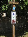 Pilgerwegweiser am Kloster Loccum.JPG 2,112 × 2,816; 2.23 MB
-
 Pixhaier-Teich-02.jpg 2,048 × 1,536; 557 KB
-
 Richtungsweisende Schilder am Pilsimer Leuchtturm 20200911 DSC3662.jpg 4,000 × 6,000; 11.67 MB
-
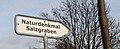 Salzgraben-Hinweis.jpg 2,153 × 881; 524 KB
-
 Schild Alfhausen Fahrradfahren.jpg 6,000 × 4,000; 6.84 MB
-
 Schild Dolmengrab.jpg 1,600 × 1,200; 335 KB
-
 Schild Forstweg Gesperrt für Motorfahrzeuge und Pferdegespanne.jpg 3,240 × 4,320; 5.36 MB
-
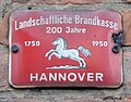 Schild Landschaftliche Brandkasse Hannover.jpg 700 × 550; 138 KB
-
 Schild Mittelalterzentrum Nienover.jpg 1,280 × 1,024; 561 KB
-
 Schild(er) am Pilsumer Leuchtturm 20200911 DSC3655.jpg 6,000 × 4,000; 10.47 MB
-
 Schild(er) im Neuenburger Urwald 20200912 DSC3775.jpg 4,000 × 6,000; 14.6 MB
-
 Schintzeljagd-Schild am Pilsumer Leuchtturm 20200911 DSC3657.jpg 4,000 × 6,000; 7.5 MB
-
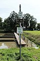
 Schleusenanlagen am Mittellandkanal in Sülfeld (Wolfsburg) IMG 4141.jpg 3,000 × 2,000; 2.24 MB
-
 Schloss Bredebeck Teich.JPG 3,648 × 2,736; 4.18 MB
-
 Schwarze Heide - Eiszapfen 3.JPG 3,483 × 2,331; 2.31 MB
-
 Schwindebachquelle Hinweisschild.jpg 2,860 × 4,290; 2.05 MB
-
 Silberborn Kreuz Stab.jpg 1,024 × 1,280; 1.13 MB
-
 St John's chapel bilingual short description DE & EN.jpg 3,448 × 5,172; 7.01 MB
-
 Standsicherheit festgestellt.jpg 1,764 × 2,646; 1.63 MB
-
 Steinfeld Kokenberg Weser Ems Wasserscheide.jpg 2,915 × 3,885; 2.92 MB
-
 Steinhuder Meer bei Hagenburg IMG 8397.jpg 2,000 × 3,000; 2.04 MB
-
 Strassenbahn-bhv-09 hg.jpg 4,309 × 2,790; 1.58 MB
-
 Tafel zur Milchrampe in Dedensen (Seelze) IMG 2900.jpg 2,772 × 2,000; 1.68 MB
-
 Telefonmast Kennzeichnungen.jpg 2,263 × 3,395; 2.16 MB
-
 Abbegraben - Informationstafel nahe Torfhaus 2013.JPG 1,280 × 1,707; 1.11 MB
-
 Truppenübungsplatz-Bergen-Live-Fire-Exercises.jpg 2,032 × 1,524; 1.58 MB
-
 Tülau Wegweiser.JPG 1,572 × 2,440; 3.68 MB
-
 Verden an der aller , Germany - panoramio (74).jpg 5,446 × 3,622; 5.87 MB
-
 Verden an der aller , Germany - panoramio (75).jpg 5,454 × 3,287; 5.67 MB
-
 Viehtrieb in Moorhausen (Varel).jpg 1,500 × 1,019; 1.3 MB
-

-
 Vörden - Campemoor - Moorlehrpfad 04.jpg 4,403 × 3,306; 10.75 MB
-
 Warft Ziallerns Plan.jpg 552 × 651; 178 KB
-
 Warntafel Totes Moor am Steinhuder Meer (Neustadt am Rübenberge) IMG 7652.jpg 3,000 × 2,000; 3.89 MB
-
 Warntafel Totes Moor am Steinhuder Meer (Neustadt am Rübenberge) IMG 7655.jpg 3,000 × 2,000; 2.6 MB
-
 Wegweiser am Kloster Loccum.JPG 2,816 × 2,112; 3.46 MB
-
 Wendebachstausee-07.jpg 3,216 × 2,136; 3.58 MB
-
 Wendebachstausee-07a.jpg 1,386 × 1,006; 773 KB
-
-
 Wiedervernässung Lebensgefahr.jpg 2,560 × 1,920; 1.55 MB
-
 Wildtiere 01.jpg 1,401 × 1,101; 1.1 MB
-
 Wildtiere 02.jpg 1,401 × 1,101; 1.09 MB
-
 2007 07 Willkommen in Wilhelmshaven.JPG 1,024 × 768; 223 KB
-
 Willershausen Tongrube Infotafeln.jpg 2,232 × 3,968; 2.68 MB
-
 …and put them in a tree museum.jpg 1,664 × 1,200; 2.52 MB


_Einstimmiger_Beschluss_des_Hochschulrates,_des_Senates_und_des_Pr%C3%A4sidiums_zu_NS-bedingten_Beeintr%C3%A4chtigungen_und_Unrechtsakten_ab_1933.jpg)


_F%C3%A4hre_Oldau_2008_by-RaBoe_12.jpg)
_IMG_9244.jpg)
.JPG)
.JPG)


.JPG)
.jpg)
.jpg)
.jpg)
.jpg)


.jpg)
.jpg)
.jpg)
.jpg)
.jpg)
.jpg)
.jpg)
.jpg)

.jpg)
.jpg)
.jpg)


_-_Finkenkuhle_-_Schild_(2).jpg)
_-_Geo-Punkt_6_-_Aufschluss_im_unteren_Muschelkalk_(2).jpg)

.jpg)
.jpg)

_IMG_6898.jpg)
_IMG_6900.jpg)
.jpg)

.JPG)
.jpg)
.jpg)
.jpg)
.jpg)
.jpg)
.jpg)
.jpg)
.jpg)
.jpg)


,_Schild_am_F%C3%B6rster-Ludewig-Platz.jpg)


.jpg)

.jpg)


_am_Pilsumer_Leuchtturm_20200911_DSC3655.jpg)
_im_Neuenburger_Urwald_20200912_DSC3775.jpg)

_IMG_4141.jpg)


_IMG_2900.jpg)


.jpg)
.jpg)
.jpg)
.jpg)


_IMG_7652.jpg)
_IMG_7655.jpg)


_near_Bevern,_Niedersachsen,_Germany._-_panoramio.jpg)


