Category:Sieverser Stein
 | |||||
| Upload media | |||||
| Instance of | |||||
|---|---|---|---|---|---|
| Part of |
| ||||
| Depicts | Wolfsangel | ||||
| Made from material | |||||
| Location | Rosengarten, Harburg, Lower Saxony, Germany | ||||
| Commissioned by | |||||
| Inception |
| ||||
| Mountain range | |||||
 | |||||
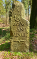
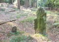
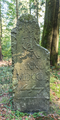
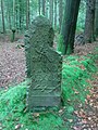
The "Sieverser Stein" (Engl.:"Sieversen Stone" or "Stone of Sieversen") was set in 1754 to mark the beginning of a forest boundary between the state forest of the then Duchy of Brunswick-Lüneburg (ruled by King George II of Great Britain in his capacity as hereditary Prince-Elector (German: Kurfürst) of Hanover), and the common forest accessible to local farmers (German: Bauernwald). The stone bears the inscription (from top to bottom): "No. I" (it was the first of 65 stones set along the eastern boundary of the state forest; the digit "I" is now missing); the monogram of George II of England ("GR II"), "ANNO MDCCL" (i.e. "In the year 1750", the year in which this boundary was originally established) and the "Wolfsangel" emblem. The stone can be found in the woods between Sieversen and Langenrehm (both Lower Saxony), Germany.
Media in category "Sieverser Stein"
The following 6 files are in this category, out of 6 total.
-
 Nr. 1 von 65 Sieverser Stein Ostgrenze.png 2,352 × 3,788; 18.57 MB
-

-
 Sieverser Stein IMG 0586.png 4,537 × 1,974; 18 MB
-
 Sieverser Stein IMG 0594.png 4,101 × 2,937; 20.55 MB
-
 Sieverser Stein IMG 0598.png 2,172 × 4,344; 16.64 MB
-
 Sieverser Stein.JPG 1,536 × 2,048; 2.13 MB

_(li)_und_Forstgrenzstein_Nr._1_der_S%C3%BCdgrenze_(re)_in_Rosengarten_(Landkreis_Harburg).jpg)


