Category:Siegenburg Range
Jump to navigation
Jump to search
 | |||||
| Upload media | |||||
| Instance of | |||||
|---|---|---|---|---|---|
| Location |
| ||||
 | |||||
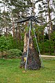
Siegenburg Range war ein Luft-Boden-Schießplatz der United States Air Force und lag im Dürnbucher Forst, Landkreis Kelheim, Niederbayern.
Media in category "Siegenburg Range"
The following 8 files are in this category, out of 8 total.
-
 Fluglärmgegnerinitiative Siegenburg Loge.JPG 1,980 × 1,964; 742 KB
-
 Siegenburg Range 1.jpg 4,800 × 3,200; 4.93 MB
-
 Siegenburg Range 2.jpg 4,800 × 3,200; 5.22 MB
-
 Siegenburg Range 3.jpg 4,800 × 3,200; 4.12 MB
-
 Siegenburg Range 4.jpg 4,021 × 2,681; 3.22 MB
-
 Siegenburg Range 5.jpg 3,200 × 4,800; 6.96 MB
-
 Siegenburg Range 6.jpg 4,800 × 3,200; 5.39 MB
-
 Siegenburg Range Mahnmal Lkr Kelheim Niederbayern.JPG 2,208 × 3,048; 4.9 MB


