Category:Shubert's maps of Kursk Governorate
Jump to navigation
Jump to search
Media in category "Shubert's maps of Kursk Governorate"
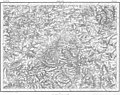
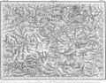
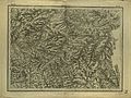
The following 21 files are in this category, out of 21 total.
-
 Shubert map - R18L13.jpg 7,150 × 5,636; 20.29 MB
-
 Shubert map - R18L14.jpg 7,094 × 5,604; 21.11 MB
-
 Shubert map - R18L15.jpg 7,278 × 5,692; 24.06 MB
-
 Shubert map - R19L12.jpg 4,723 × 3,617; 6.22 MB
-
 Shubert map - R19L14.jpg 8,005 × 6,058; 16.79 MB
-
 Shubert map - R19L15.jpg 8,142 × 6,097; 17.04 MB
-
 Shubert map - R19L16.jpg 7,899 × 5,983; 16.14 MB
-
 Shubert map - R20L11.jpg 4,874 × 3,671; 6.68 MB
-
 Shubert map - R20L12.jpg 8,254 × 6,084; 17.16 MB
-
 Shubert map - R20L13.jpg 7,399 × 5,885; 9.4 MB
-
 Shubert map - R20L14.jpg 7,461 × 5,716; 23.23 MB
-
 Shubert map - R20L15.jpg 7,244 × 5,608; 11.68 MB
-
 Shubert map - R20L16.jpg 7,836 × 5,933; 12.74 MB
-
 Shubert map - R21L11.jpg 7,890 × 6,062; 15.7 MB
-
 Shubert map - R21L12.jpg 7,912 × 5,933; 16.04 MB
-
 Shubert map - R21L13.jpg 7,874 × 5,887; 16.69 MB
-
 Shubert map - R21L14.jpg 7,184 × 5,542; 11.51 MB
-
 Shubert map - R21L15.jpg 7,912 × 6,054; 17.7 MB
-
 Shubert map - R21L16.jpg 7,649 × 5,888; 13.9 MB
-
 Shubert map - R22L13.jpg 7,175 × 5,525; 8.73 MB
-
 Shubert map - R22L15.jpg 7,860 × 5,993; 16.47 MB


