Category:Shrigley Road Aqueduct
Jump to navigation
Jump to search
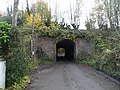
Aqueduct carrying the Macclesfield Canal over Shrigley Road, Pott Shrigley, Cheshire East, Cheshire, England.
| Object location | | View all coordinates using: OpenStreetMap |
|---|
Grade II listed canal aqueduct in the parish of Pott Shrigley, Cheshire East, Cheshire, England, UK  | |||||
| Upload media | |||||
| Instance of | |||||
|---|---|---|---|---|---|
| Location | Pott Shrigley, Cheshire East, Cheshire, North West England, England | ||||
| Carries | |||||
| Heritage designation |
| ||||
 | |||||
Media in category "Shrigley Road Aqueduct"
The following 3 files are in this category, out of 3 total.
-
 Shrigley Road Aqueduct 01.jpg 4,000 × 3,000; 6.67 MB
-
 Shrigley Road Aqueduct 02.jpg 4,000 × 3,000; 6.42 MB
-
 Shrigley Road Aqueduct 03.jpg 4,000 × 3,000; 6.42 MB

