Category:Shire of Colac Otway
Jump to navigation
Jump to search
Deutsch: Das Colac Otway Shire ist ein lokales Verwaltungsgebiet (LGA) im australischen Bundesstaat Victoria. Das Gebiet ist 3.533 km² groß und hat etwa 22.000 Einwohner. (→Colac Otway Shire)
English: The Shire of Colac Otway is a local government area in the Barwon South West region of Victoria, Australia, located in the south-western part of the state. It covers an area of and, at the 2011 Census, had a population of 20,345. It includes the towns of Apollo Bay, Beeac, Beech Forest, Birregurra, Colac, Cressy, Forrest, Johanna, Kennett River, Lavers Hill, Warrion and Wye River. It was formed in 1994 from the amalgamation of the City of Colac, Shire of Colac, Shire of Otway and part of the Shire of Heytesbury. (→Shire of Colac Otway)
Français : Le comté de Colac Otway est une zone d'administration locale de l'État de Victoria en Australie. Il est situé dans la partie sud-ouest de l'état. Il comprend les villes de Apollo Bay et Colac. Il a été créé en 1994 par la fusion de la Ville de Colac, du comté de Colac, du comté d'Otway et d'une partie du comté d'Heytesbury. (→Comté de Colac Otway)
Italiano: La Contea di Colac Otway è una Local Government Area che si trova nello stato di Victoria. Essa si estende su di una superficie di 3.433 chilometri quadrati ed ha una popolazione di 20.345 abitanti. La sede del consiglio si trova a Colac. (→Contea di Colac Otway)
Nederlands: Colac Otway Shire is een Local Government Area (LGA) in Australië in de staat Victoria. Colac Otway Shire telt 21.802 inwoners. De hoofdplaats is Colac. (→Colac Otway Shire)
Polski: Hrabstwo Colac Otway ( ang. Colac Otway Shire) – obszar samorządu lokalnego (ang. local government area) położony w południowo-zachodniej części stanu Wiktoria. Samorząd powstał w wyniku stanowej reformy samorządowej w 1994 roku z połączenia następujących jednostek: City of Colac oraz hrabstw Colac, Otway i z części Heytesbury. (→Hrabstwo Colac Otway)
local government area in Victoria, Australia  | |||||
| Upload media | |||||
| Instance of | |||||
|---|---|---|---|---|---|
| Location | Victoria, AUS | ||||
| Capital | |||||
| Inception |
| ||||
| Population |
| ||||
| Area |
| ||||
| Elevation above sea level |
| ||||
| official website | |||||
 | |||||
Subcategories
This category has the following 15 subcategories, out of 15 total.
A
B
C
F
J
- Johanna, Victoria (11 F)
K
- Kennett River, Victoria (8 F)
L
S
- Swan Marsh (5 F)
W
- Warrion, Victoria (5 F)
- Weeaproinah, Victoria (28 F)
- Wye River, Victoria (1 P, 7 F)
Media in category "Shire of Colac Otway"
The following 15 files are in this category, out of 15 total.
-
 A road surrounded by dead trees in the Otways (Australia).jpg 5,472 × 3,648; 5.59 MB
-
 Along the Great Ocean Road - panoramio.jpg 2,990 × 1,731; 2.31 MB
-
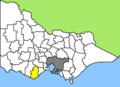 Australia-Map-VIC-LGA-Colac Otway.png 550 × 400; 8 KB
-
 Corangamite Water Watch Stormwater Trail Plaque - panoramio.jpg 3,264 × 2,448; 3.14 MB
-
 Dinosaur Cove.jpg 3,573 × 1,701; 1.75 MB
-
 Follow Me (59131998).jpeg 1,365 × 2,048; 1.58 MB
-
 Hidden Treasure (59132990).jpeg 2,048 × 1,365; 1.6 MB
-
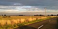 Langs James Rd Balintore.jpg 960 × 485; 86 KB
-
 Life (59131634).jpeg 2,048 × 1,365; 913 KB
-
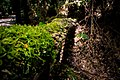
 Mait S Rest Rainforest Walk (59131690).jpeg 2,048 × 1,365; 1.83 MB
-
 Rob in the Rainforest (869696555).jpg 960 × 1,280; 405 KB
-
 Sunset Over 12 Apostles (60764370).jpeg 2,048 × 1,343; 1.15 MB
-
 The Edge Of The World (154236713).jpeg 2,048 × 1,367; 882 KB
-
 The Port Campbell Mountains.jpg 4,032 × 3,024; 1.95 MB
-
 Tree Ferns - panoramio.jpg 2,272 × 1,704; 1.75 MB
.jpg)


.jpeg)
.jpeg)

.jpeg)
.jpeg)
.jpg)
.jpeg)
.jpeg)

