Category:Shepaug Railroad
Jump to navigation
Jump to search
transport company in United States of America  | |||||
| Upload media | |||||
| Instance of | |||||
|---|---|---|---|---|---|
| Location |
| ||||
| Inception |
| ||||
| Date of official opening |
| ||||
| Date of official closure |
| ||||
| Replaced by | |||||
| |||||
English: Media pertaining to the former Shepaug, Litchfield and Northern Railroad, that was known by several other names including "Shepaug Railroad". It was eventually owned by two different companies. The line ran through Fairfield and Litchfield Counties in Connecticut, USA. The tracks have been lifted (around 1948 or 1949) and much of the former right of way is currently used as a rail trail.

Subcategories
This category has the following 4 subcategories, out of 4 total.
Media in category "Shepaug Railroad"
The following 23 files are in this category, out of 23 total.
-
 Hanover Springs station site 068.JPG 2,048 × 1,536; 1.59 MB
-
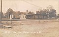 Hawleyville station postcard.jpg 1,076 × 682; 75 KB
-
 Judd's Bridge station 043.JPG 2,048 × 1,536; 1.23 MB
-
 Litchfield Community Greenway green blaze 093.JPG 2,048 × 1,536; 1.09 MB
-
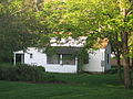
 Morris station site house 086.JPG 2,048 × 1,536; 1.32 MB
-
 New Preston station site 080.JPG 2,048 × 1,536; 1.25 MB
-
 Romford freight depot 081.JPG 2,048 × 1,536; 1.24 MB
-
 Roxbury elevated right of way 015.JPG 2,048 × 1,536; 1.66 MB
-
 Roxbury Falls right of way 072.JPG 1,536 × 2,048; 1.9 MB
-
 Roxbury Falls station site 071.JPG 2,048 × 1,536; 1.67 MB
-
 Roxbury freight depot remains 059.JPG 2,048 × 1,536; 810 KB
-
 Roxbury stone lintel culvert 058.JPG 2,048 × 1,536; 1.18 MB
-
 Sectional map of N. Y. N. H. & H. R.R. Berkshire Hills Route.jpg 1,746 × 3,666; 1.23 MB
-
 Sectional map of the N.Y. N.H. and H. Berkshire Hills Route.png 1,808 × 4,528; 3.1 MB
-
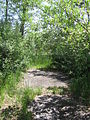
 Shepaug Rail Trail 060.JPG 2,048 × 1,536; 1.35 MB
-
 Shepaug Railway through Mallard Marsh 094.JPG 1,536 × 2,048; 986 KB
-
 Shepaug Railway through Mallard Marsh 095.JPG 1,536 × 2,048; 1.21 MB
-
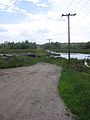
 Shepaug Reload entrance 155.JPG 2,048 × 1,536; 670 KB
-
 Stairway to Holiday House 062.JPG 2,048 × 1,536; 1.42 MB
-
 Steep Rock stone lintel 022.JPG 2,048 × 1,536; 1.2 MB
-
 Valley Station bridge 061.JPG 2,048 × 1,536; 1.27 MB
-
 Valley station pedestrian bridge 013.JPG 2,048 × 1,536; 939 KB
-
 Valley station pedestrian bridge 014.JPG 2,048 × 1,536; 1 MB


