Category:Severinuskerk (Grathem)
Jump to navigation
Jump to search
| Object location | | View all coordinates using: OpenStreetMap |
|---|
church in Grathem, Netherlands  | |||||
| Upload media | |||||
| Instance of | |||||
|---|---|---|---|---|---|
| Dedicated to | |||||
| Location | Grathem, Limburg, Netherlands | ||||
| Street address |
| ||||
| Located on street |
| ||||
| Diocese | |||||
| Heritage designation |
| ||||
| Inception |
| ||||
| Religion or worldview | |||||
 | |||||
Nederlands: Severinuskerk, Grathem - anno 16e eeuw
|
This is a category about rijksmonument number 17203
|
| Address |
|
Media in category "Severinuskerk (Grathem)"
The following 19 files are in this category, out of 19 total.
-
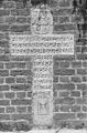 Exterieur GRAFKRUIS IN MUUR BIJ KERK - Grathem - 20272105 - RCE.jpg 788 × 1,200; 380 KB
-
 Exterieur GRAFKRUIS IN MUUR BIJ KERK - Grathem - 20272106 - RCE.jpg 788 × 1,200; 348 KB
-

-
 Exterieur OVERZICHT SIERBESTRATING VOOR DE KERK - Grathem - 20272102 - RCE.jpg 788 × 1,200; 281 KB
-
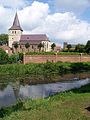 Graetem Graetemmermolen omgeving.JPG 3,000 × 4,000; 3.42 MB
-
 Interieur biechtstoel met beelden - Grathem - 20326159 - RCE.jpg 1,200 × 851; 202 KB
-
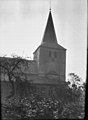
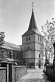
 Kerk vanuit het noord-westen en het oosten - Grathem - 20083542 - RCE.jpg 1,200 × 1,188; 314 KB
-
 Kerk vanuit het noord-westen en het oosten - Grathem - 20083543 - RCE.jpg 1,200 × 1,192; 305 KB
-
 Kerk vanuit het noord-westen en het oosten - Grathem - 20083544 - RCE.jpg 2,136 × 2,116; 1.04 MB
-
 Kerk vanuit het noorden en het noord-westen - Grathem - 20083545 - RCE.jpg 879 × 1,200; 178 KB
-
 Kerk vanuit het noorden en het noord-westen - Grathem - 20083546 - RCE.jpg 872 × 1,200; 236 KB
-
 Overzicht van de kerk - Grathem - 20083548 - RCE.jpg 3,319 × 2,224; 2.24 MB
-
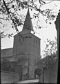
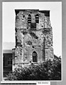
 Toren - Grathem - 20083547 - RCE.jpg 806 × 1,200; 193 KB
-
 Toren naar het noord-westen - Grathem - 20083537 - RCE.jpg 923 × 1,200; 274 KB
-
 Toren naar het noorden - Grathem - 20083540 - RCE.jpg 933 × 1,200; 271 KB
-
 Toren naar het zuid-oosten - Grathem - 20083539 - RCE.jpg 922 × 1,200; 263 KB
-
 Toren naar het zuid-oosten - Grathem - 20083541 - RCE.jpg 957 × 1,200; 247 KB
-
 Toren west-zijde - Grathem - 20083538 - RCE.jpg 933 × 1,200; 286 KB
-
 Zicht vanuit het zuidwesten met boomgaard - Grathem - 20326601 - RCE.jpg 874 × 1,200; 136 KB


_VOOR_KERK_-_Grathem_-_20272104_-_RCE.jpg)


