Category:Sett Valley Trail
Jump to navigation
Jump to search

footpath, cycle trail and bridleway in Derbyshire, England  | |||||
| Upload media | |||||
| Instance of | |||||
|---|---|---|---|---|---|
| Location | High Peak, Derbyshire, East Midlands, England | ||||
| Length |
| ||||
| Terminus | |||||
 | |||||
Subcategories
This category has the following 2 subcategories, out of 2 total.
H
- Hayfield bus station (24 F)
Media in category "Sett Valley Trail"
The following 38 files are in this category, out of 38 total.
-
 Bank Cottages, Hayfield - geograph.org.uk - 1079514.jpg 640 × 480; 79 KB
-
 Bench on the Sett Valley Trail - geograph.org.uk - 4150751.jpg 800 × 533; 151 KB
-
 Come into my freezer... - geograph.org.uk - 1066120.jpg 640 × 480; 71 KB
-
 Footpath crossing the Sett Valley Trail - geograph.org.uk - 4150759.jpg 800 × 533; 182 KB
-
 Former crossing on the Sett Valley Trail - geograph.org.uk - 2298571.jpg 3,872 × 2,592; 4.72 MB
-
 Gate at the end of the Sett Valley trail - geograph.org.uk - 1343297.jpg 640 × 480; 143 KB
-
 Gatekeepers cottage at Wilde's Crossing - geograph.org.uk - 4209399.jpg 1,024 × 768; 267 KB
-
 High Hill Road, Thornsett - geograph.org.uk - 1066131.jpg 640 × 480; 101 KB
-
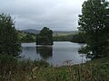 Reservoir with island - geograph.org.uk - 1440954.jpg 640 × 480; 70 KB
-

-
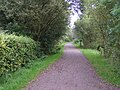
 Sett Valley Trail - geograph.org.uk - 1066157.jpg 640 × 480; 136 KB
-
 Sett Valley Trail - geograph.org.uk - 1343035.jpg 640 × 480; 109 KB
-
 Sett Valley Trail - geograph.org.uk - 148336.jpg 640 × 480; 188 KB
-
 Sett Valley Trail - geograph.org.uk - 221602.jpg 480 × 640; 335 KB
-
 Sett Valley Trail - geograph.org.uk - 5285612.jpg 1,280 × 851; 622 KB
-
 Sett Valley Trail - geograph.org.uk - 5285699.jpg 1,280 × 851; 611 KB
-
 Sett Valley Trail - geograph.org.uk - 5288218.jpg 1,280 × 851; 671 KB
-
 Sett Valley Trail - Path Crossing - geograph.org.uk - 1504564.jpg 640 × 480; 102 KB
-
 Sett Valley Trail - Picnic Area View - geograph.org.uk - 1504751.jpg 640 × 480; 102 KB
-

-
 Sett Valley Trail Winter Scene - geograph.org.uk - 2800794.jpg 3,296 × 2,472; 1.14 MB
-
 Sett Valley Trail, New Mills - geograph.org.uk - 1066125.jpg 640 × 423; 127 KB
-
 Sett Valley Trail, New Mills - geograph.org.uk - 1183294.jpg 640 × 480; 148 KB
-
 Sett Valley Trail.svg 1,738 × 957; 202 KB
-
 SettValleyTrail.JPG 1,280 × 960; 326 KB
-
 The Sett Valley Trail - geograph.org.uk - 2298567.jpg 3,872 × 2,592; 6.15 MB
-
 The Special Touch Cafe - geograph.org.uk - 1066168.jpg 640 × 426; 93 KB
-
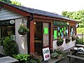 The Special Touch Cafe - geograph.org.uk - 1343084.jpg 640 × 480; 93 KB
-
 View from the Sett Valley Trail - geograph.org.uk - 5288225.jpg 1,280 × 851; 448 KB
-
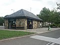 Visitor Information Centre, Hayfield - geograph.org.uk - 221338.jpg 640 × 480; 250 KB
-
 Watford Bridge on the Sett Valley Trail - geograph.org.uk - 4209386.jpg 1,024 × 768; 331 KB
-
 Watford Bridge Road, New Mills - geograph.org.uk - 1066117.jpg 640 × 463; 152 KB
-
 Wildes Crossing Cottage - geograph.org.uk - 1066141.jpg 640 × 444; 97 KB
-
 Wildes Crossing Cottage - geograph.org.uk - 1183267.jpg 640 × 480; 102 KB
-

-
 Wildes Crossing, Sett Valley Trail - geograph.org.uk - 51198.jpg 480 × 640; 138 KB
-
 Across the Sett Valley - geograph.org.uk - 221314.jpg 640 × 480; 253 KB
-
 Pasture, Hayfield - geograph.org.uk - 221558.jpg 640 × 480; 272 KB


